
Bestand:Beauplan Poland XVII map.jpg
Oorspronkelijk bestand (6.674 × 5.244 pixels, bestandsgrootte: 25,99 MB, MIME-type: image/jpeg)
| Dit is een bestand van Wikimedia Commons. Onderstaande beschrijving komt van de beschrijving van het bestand daar. |
Beschrijving
| Beschrijving |
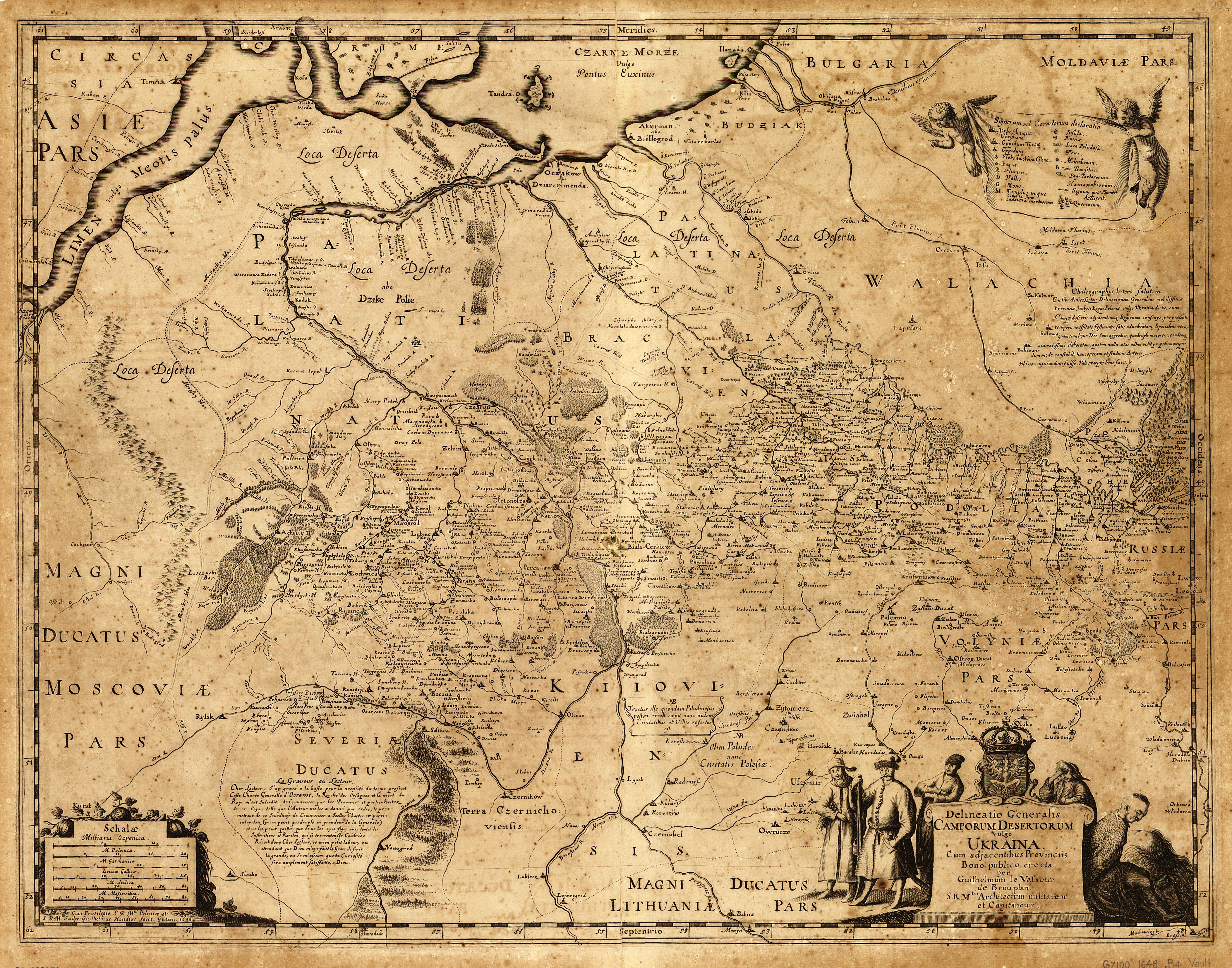
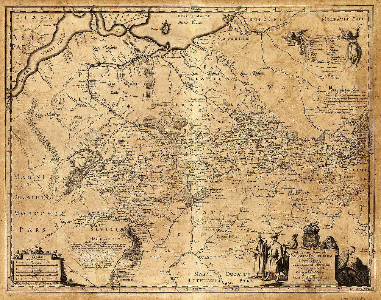
English: «Delineatio Generalis Camporum Desertorum vulgo Ukraina. Cum adjacentibus Provinciis».
Latina: Delineatio generalis Camporum Desertorum vulgo Ukraina: cum adjacentibus provinciis / bono publico erecta per Guilhelmum le Vasseur de Beauplan, S. R. M'tis architectum militarem et capitaneum ; sculpt. Guilhelmus Hondius fecit, Gedani, 1648.
Polski: Mapa Dzikich Pól inaczej Ukrainy, z przyległymi prowincjami. Sporządzona dla dobra publicznego przez Wilhelma de Beauplana w 1648 w Gdańsku na polecenie Władysława IV, Króla Polski
|
| Datum | |
| Bron | Description de l'Ukrainie, qui sont plusieurs provinces du Royaume de Pologne, Contenuës depuis les confins de la Moscovie, jusques aux limites de la Transilvanie. Ensemble leurs moeurs, façcons de vivres et de faire la Guerre. Par le Sieur de Beauplan |
| Auteur | Vasseur de Beauplan |
NOTES Scale ca. 1:1,750,000.
Relief shown pictorially.
Oriented with north to the bottom.
Includes text in Latin and French and ill.
SUBJECTS Ukraine--Maps--Early works to 1800. Ukraine.
RELATED NAMES Hondius, Willem.
MEDIUM 1 map ; 43 x 55 cm.
CALL NUMBER G7100 1648 .B4 Vault
REPOSITORY Library of Congress Geography and Map Division Washington, D.C. 20540-4650 USA http://memory.loc.gov/cgi-bin/query/h?ammem/gmd:@field%28NUMBER+@band%28g7100+ct000383%29%29
Licentie
|
Dit werk bevindt zich in het publiek domein in landen en gebieden waar de auteursrechttermijn het leven van de auteur plus 100 jaar of minder is. Dit werk bevindt zich in het publiek domein in de Verenigde Staten omdat het gepubliceerd werd (of geregistreerd bij de U.S. Copyright Office) voor 1 januari 1929. | |
| Van dit bestand is vastgesteld dat er geen bekende auteursrechtaanspraken op rusten, alle aanverwante en naburige rechten daarbij inbegrepen. | |
Bestandsgeschiedenis
Klik op een datum/tijd om het bestand te zien zoals het destijds was.
| Datum/tijd | Miniatuur | Afmetingen | Gebruiker | Opmerking | |
|---|---|---|---|---|---|
| huidige versie | 15 jun 2014 14:10 | | 6.674 × 5.244 (25,99 MB) | Gerodian | Карта с большим разрешением и в лучшем качестве |
| 13 okt 2013 15:51 |  | 3.000 × 2.357 (2,52 MB) | Andros64 | better quality | |
| 24 jan 2011 12:02 |  | 3.000 × 2.357 (1,95 MB) | Bornholm | {{Information |Description ={{en|1=The map Kingdom of Poland (es. "Wild Fields") near the Black Sea from 17 c. made on order King of Poland Władysław IV Vasa by Guillaume le Vasseur de Beauplan. Original latin name: Delineatio generalis Camporum Dese |
Bestandsgebruik
Dit bestand wordt op de volgende 2 pagina's gebruikt:
Globaal bestandsgebruik
De volgende andere wiki's gebruiken dit bestand:
- Gebruikt op ar.wikipedia.org
- Gebruikt op az.wikipedia.org
- Gebruikt op be-tarask.wikipedia.org
- Gebruikt op ca.wikipedia.org
- Gebruikt op ce.wikipedia.org
- Gebruikt op cs.wikipedia.org
- Gebruikt op de.wikipedia.org
- Gebruikt op en.wikipedia.org
- Gebruikt op es.wikipedia.org
- Gebruikt op et.wikipedia.org
- Gebruikt op fr.wikipedia.org
- Gebruikt op it.wikipedia.org
- Gebruikt op la.wikipedia.org
- Gebruikt op lt.wikipedia.org
- Gebruikt op pl.wikipedia.org
- Gebruikt op ro.wikipedia.org
- Gebruikt op ru.wikipedia.org
Globaal gebruik van dit bestand bekijken.