
Bestand:CEM-36-NE-corner.jpg

Grootte van deze voorvertoning: 800 × 600 pixels. Andere resoluties: 320 × 240 pixels | 640 × 480 pixels | 1.024 × 768 pixels | 1.280 × 960 pixels | 2.560 × 1.920 pixels.
Oorspronkelijk bestand (2.560 × 1.920 pixels, bestandsgrootte: 2,02 MB, MIME-type: image/jpeg)
| Dit is een bestand van Wikimedia Commons. Onderstaande beschrijving komt van de beschrijving van het bestand daar. |
Beschrijving
| Beschrijving |
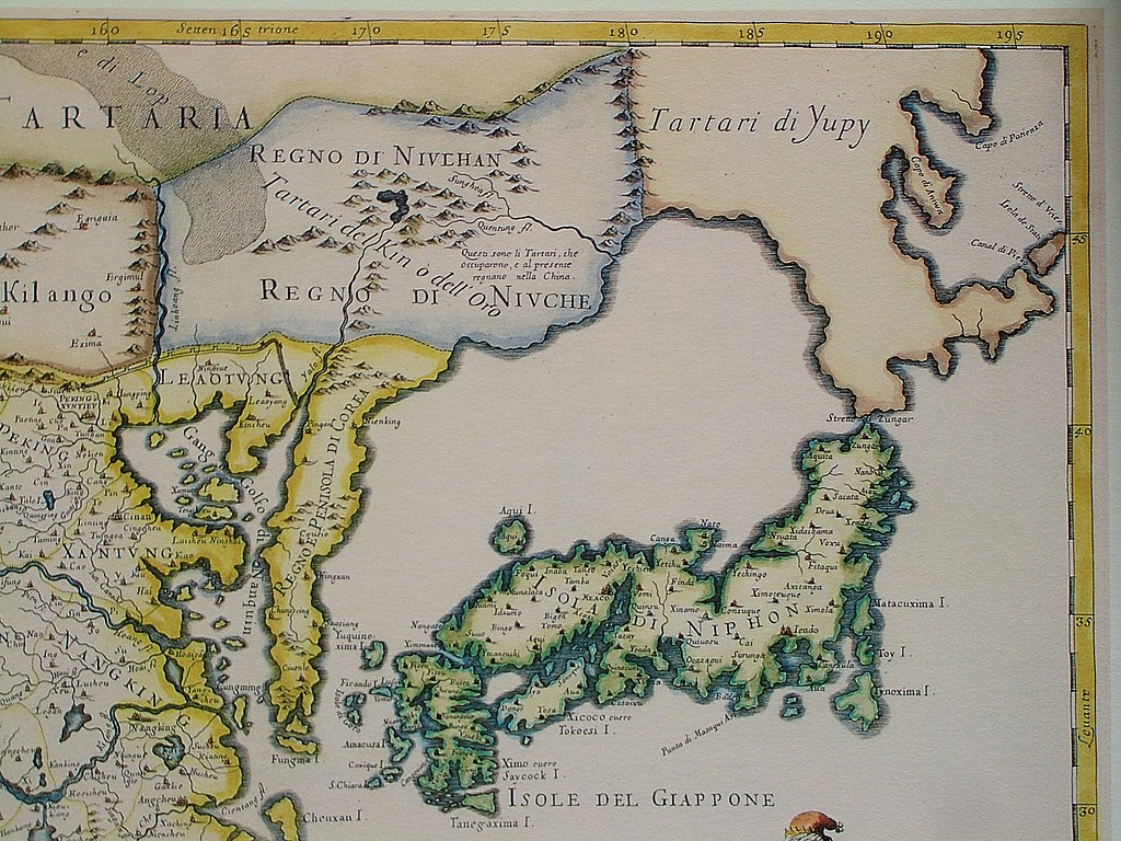
English: The north-eastern corner of a map of China (in Italian): "The Kingdom of China, presently called Catay and Mangin, divided into its principal provinces on a most precise map". This part shows includes Sea of Japan and Japan itself. However, neither the La Pérouse Strait nor the Strait of Tartary were known to the cartographer, and therefore Hokkaido and Sakhalin are all part of the mainland, populated by the "Yupi Tartars" (i.e. the "Fishskin Tartars" - the old Chinese name for the Nanai people and related groups). However, the eastern coast of Sakhalin, with Cape Aniwa and Cape Patience are already charted more or less correctly (thanks to a Dutch expedition in the 1640s). Sakhalin and Hokkaido are both represented as one peninsula in Yupi Tartars, and are separated from Japan by "Stretto di Züngar" (today Tsugaru Strait), between today Hokkaido and Honshu (Isola di Niphon). Probably in reference of the city of "Züngar" (today Tsugaru) shown in north of Honshu.
Italiano: "Il regno della China detto presentemente Catay e Mangin diuiso sopra le carte piu esatte nelle sue principali prouincie" |
|||||
| Datum | Originally published 1682; the copy at HKUST is a 1689 reprint. | |||||
| Bron |
English: An antique map from the Special Collection "China in Maps" of the Hong Kong University of Science and Technology Library, reproduced by the HKUST Library in the book "China in European Maps", Hong Kong, 2003. ISBN 962-86403-9-9.
Русский: Старинная карта из специальной коллекции Библиотеки Гонконгского научно-технического университета. Опубликована этой библиотекой в книге "China in European Maps" (Китай на европейских картах), Гонконг, 2003. ISBN 962-86403-9-9, тиражом 1000 экз. См. также каталог выставки, Special Collection "China in Maps".
Plate 36: "Il regno della China detto presentemente Catay e Mangin diuiso sopra le carte piu esatte nelle sue principali prouincie" |
|||||
| Auteur | Giacomo Cantelli da Vignola (1643-1695), Giovanni Giacomo de Rossi (1627-1691) | |||||
| Toestemming (Hergebruik van dit bestand) |
|
|||||
| Andere versies |
Entire map:  |
|||||
| Aantekeningen | Deze afbeelding is aangetekend: Bekijk de aantekeningen op Commons |
Bestandsgeschiedenis
Klik op een datum/tijd om het bestand te zien zoals het destijds was.
| Datum/tijd | Miniatuur | Afmetingen | Gebruiker | Opmerking | |
|---|---|---|---|---|---|
| huidige versie | 19 mrt 2009 14:52 | | 2.560 × 1.920 (2,02 MB) | Vmenkov | {{Information |Description={{en|1=The north-eastern cornet of a map of China (in Italian): "The Kingdom of China, presently called Catay and Mangin, divided into its principal provinces on a most precise map". This part shows includes Sea of Japan and Ja |
Bestandsgebruik
Dit bestand wordt op de volgende pagina gebruikt:
Globaal bestandsgebruik
De volgende andere wiki's gebruiken dit bestand:
- Gebruikt op af.wikipedia.org
- Gebruikt op ar.wikipedia.org
- Gebruikt op ast.wikipedia.org
- Gebruikt op bg.wikipedia.org
- Gebruikt op bn.wikipedia.org
- Gebruikt op cs.wikipedia.org
- Gebruikt op en.wikipedia.org
- Gebruikt op es.wikipedia.org
- Gebruikt op es.wikivoyage.org
- Gebruikt op fr.wikipedia.org
- Gebruikt op fy.wikipedia.org
- Gebruikt op it.wikipedia.org
- Gebruikt op ja.wikipedia.org
- Gebruikt op my.wikipedia.org
- Gebruikt op ru.wikipedia.org
- Gebruikt op vi.wikipedia.org