
Bestand:Carte gabon.png
Geen hogere resolutie beschikbaar.
Carte_gabon.png (326 × 349 pixels, bestandsgrootte: 13 kB, MIME-type: image/png)
| Dit is een bestand van Wikimedia Commons. Onderstaande beschrijving komt van de beschrijving van het bestand daar. |
Beschrijving
| Beschrijving |
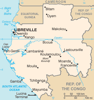
English: Map of Gabon |
| Datum |
27 maart 2005 (originele uploaddatum) 21 August 2008 (Last source update) |
| Bron | CIA World Factbook |
| Auteur | CIA |
| Andere versies |
|


Licentie
Deze afbeelding bevindt zich in het publiek domein omdat het materiaal bevat dat oorspronkelijk afkomstig is van het CIA World Factbook.
|
 |
Bestandsgeschiedenis
Klik op een datum/tijd om het bestand te zien zoals het destijds was.
| Datum/tijd | Miniatuur | Afmetingen | Gebruiker | Opmerking | |
|---|---|---|---|---|---|
| huidige versie | 24 jan 2022 20:42 | | 326 × 349 (13 kB) | Lojwe | Cropped 1 % horizontally, 1 % vertically using CropTool with precise mode. |
| 3 dec 2011 18:00 |  | 329 × 352 (13 kB) | Vincent.vaquin | more up to date map with river and more cities | |
| 3 mrt 2006 19:31 |  | 330 × 355 (36 kB) | Historicair | Carte du Gabon Carte d'origine : User:Alfio Traduction : ~~~~ {{PD-USGov-CIA-WF}} {{Atelier graphique carte}} Category:Maps of Gabon |
Bestandsgebruik
Dit bestand wordt op de volgende 3 pagina's gebruikt:
Globaal bestandsgebruik
De volgende andere wiki's gebruiken dit bestand:
- Gebruikt op ar.wikipedia.org
- Gebruikt op ast.wikipedia.org
- Gebruikt op az.wikipedia.org
- Gebruikt op be-tarask.wikipedia.org
- Gebruikt op br.wikipedia.org
- Gebruikt op ca.wikipedia.org
- Gebruikt op cs.wikipedia.org
- Gebruikt op cy.wikipedia.org
- Gebruikt op da.wikipedia.org
- Gebruikt op de.wikipedia.org
- Gebruikt op en.wikipedia.org
- Gebruikt op en.wikisource.org
- Gebruikt op eo.wikipedia.org
- Gebruikt op eu.wikipedia.org
- Gebruikt op fa.wikipedia.org
- Gebruikt op fi.wikipedia.org
- Gebruikt op fi.wikivoyage.org
- Gebruikt op fo.wikipedia.org
- Gebruikt op fr.wikipedia.org
- Gebruikt op gd.wikipedia.org
- Gebruikt op gl.wikipedia.org
- Gebruikt op hr.wikipedia.org
- Gebruikt op hu.wikipedia.org
- Gebruikt op hu.wiktionary.org
- Gebruikt op id.wikipedia.org
- Gebruikt op ilo.wikipedia.org
- Gebruikt op is.wikipedia.org
- Gebruikt op it.wikipedia.org
Globaal gebruik van dit bestand bekijken.