
Bestand:Congo regions named.png
Geen hogere resolutie beschikbaar.
Congo_regions_named.png (300 × 337 pixels, bestandsgrootte: 14 kB, MIME-type: image/png)
| Dit is een bestand van Wikimedia Commons. Onderstaande beschrijving komt van de beschrijving van het bestand daar. |
| Beschrijving |
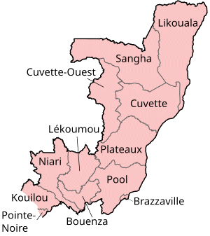
Map of the regions of the Republic of the Congo, named in French (local language), mostly compatible with English. The individual maps are: |
| Datum | |
| Bron | Self-made, traced from public domain UN or CIA maps. |
| Auteur | User:Golbez |
| Toestemming (Hergebruik van dit bestand) |
Provide attribution, please. See below. |
Ik, de auteursrechthebbende van dit werk, maak het hierbij onder de volgende licenties beschikbaar:
Dit bestand is gelicenseerd onder de Creative Commons-licenties Naamsvermelding-Gelijk delen 2.5 Algemeen, 2.0 Algemeen en 1.0 Algemeen.
- De gebruiker mag:
- Delen – het werk kopiëren, verspreiden en doorgeven
- Remixen – afgeleide werken maken
- Onder de volgende voorwaarden:
- naamsvermelding – U moet op een gepaste manier aan naamsvermelding doen, een link naar de licentie geven, en aangeven of er wijzigingen in het werk zijn aangebracht. U mag dit op elke redelijke manier doen, maar niet zodanig dat de indruk wordt gewekt dat de licentiegever instemt met uw werk of uw gebruik van zijn werk.
- Gelijk delen – Als u het werk heeft geremixt, veranderd, of erop heeft voortgebouwd, moet u het gewijzigde materiaal verspreiden onder dezelfde licentie als het oorspronkelijke werk, of een daarmee compatibele licentie.

|
Toestemming wordt verleend voor het kopiëren, verspreiden en/of wijzigen van dit document onder de voorwaarden van de GNU-licentie voor vrije documentatie, versie 1.2 of enige latere versie als gepubliceerd door de Free Software Foundation; zonder Invariant Sections, zonder Front-Cover Texts, en zonder Back-Cover Texts. Een kopie van de licentie is opgenomen in de sectie GNU-licentie voor vrije documentatie. |
| Dit bestand is gelicenseerd onder de Creative Commons-licentie Naamsvermelding-Gelijk delen 3.0 Unported | ||
| ||
| Deze licentietag is toegevoegd aan dit bestand in verband met de GFDL licentie-update. |
U mag zelf één van de licenties kiezen.
Bestandsgeschiedenis
Klik op een datum/tijd om het bestand te zien zoals het destijds was.
| Datum/tijd | Miniatuur | Afmetingen | Gebruiker | Opmerking | |
|---|---|---|---|---|---|
| huidige versie | 1 okt 2023 19:29 | | 300 × 337 (14 kB) | Yunan973 | fix all boundaries according to last offical maps (2023) |
| 28 dec 2004 18:53 |  | 300 × 370 (13 kB) | Golbez | Map of the regions of the Republic of the Congo. Made by User:Golbez. {{cc-by-sa-2.0}} |
Bestandsgebruik
Dit bestand wordt op de volgende pagina gebruikt:
Globaal bestandsgebruik
De volgende andere wiki's gebruiken dit bestand:
- Gebruikt op ast.wikipedia.org
- Gebruikt op avk.wikipedia.org
- Gebruikt op be-tarask.wikipedia.org
- Gebruikt op bg.wikipedia.org
- Gebruikt op bn.wikipedia.org
- Gebruikt op br.wikipedia.org
- Gebruikt op ca.wikipedia.org
- Gebruikt op de.wikipedia.org
- Gebruikt op el.wikipedia.org
- Gebruikt op en.wikipedia.org
- Departments of the Republic of the Congo
- Pointe-Noire
- Districts of the Republic of the Congo
- User:Jonny-mt/Gallery of current first-level administrative country subdivisions maps
- Kimongo District
- Mayoko District
- Divénié District
- Louvakou District
- Template:Districts of the Republic of the Congo
- User talk:Markussep/Archive 4
- Kibangou District
- Moutamba District
- Boko-Songho District
- Loudima District
- Madingou District
- Mfouati District
- Mouyondzi District
- Kayes District
- Boundji District
- Loukela District
- Makoua District
- Mossaka District
- Okoyo District
- Oyo District
- Ewo District
- Kelle District
- Mbomo District
- Kakamoeka District
- Madingo-Kayes District
- Mvouti District
- Bambama District
- Komono District
- Sibiti District
- Zanaga District
- Dongou District
- Epena District
- Impfondo District
Globaal gebruik van dit bestand bekijken.