
Bestand:Covering of the Senne EN v1.2.svg

Afmetingen van deze voorvertoning van het type PNG van dit SVG-bestand: 485 × 599 pixels Andere resoluties: 194 × 240 pixels | 388 × 480 pixels | 621 × 768 pixels | 828 × 1.024 pixels | 1.657 × 2.048 pixels | 1.416 × 1.750 pixels.
Oorspronkelijk bestand (SVG-bestand, nominaal 1.416 × 1.750 pixels, bestandsgrootte: 107 kB)
| Dit is een bestand van Wikimedia Commons. Onderstaande beschrijving komt van de beschrijving van het bestand daar. |
Beschrijving
| Beschrijving |
|
| Datum | Today |
| Bron | Eigen werk |
| Auteur | MapMaster |
References
Built largely from present day street maps and these two historical maps:
- Brussels (Bruxelles) by Society for the Diffusion of Useful Knowledge (Great Britain); an 1837 map of Brussels
- Brussels by Letts, Son & Co. an 1883 map of Brussels
Other versions
Licentie
Ik, de auteursrechthebbende van dit werk, maak het hierbij onder de volgende licenties beschikbaar:

|
Toestemming wordt verleend voor het kopiëren, verspreiden en/of wijzigen van dit document onder de voorwaarden van de GNU-licentie voor vrije documentatie, versie 1.2 of enige latere versie als gepubliceerd door de Free Software Foundation; zonder Invariant Sections, zonder Front-Cover Texts, en zonder Back-Cover Texts. Een kopie van de licentie is opgenomen in de sectie GNU-licentie voor vrije documentatie. |
Dit bestand is gelicenseerd onder de Creative Commons-licentie Naamsvermelding 3.0 Unported
- De gebruiker mag:
- Delen – het werk kopiëren, verspreiden en doorgeven
- Remixen – afgeleide werken maken
- Onder de volgende voorwaarden:
- naamsvermelding – U moet op een gepaste manier aan naamsvermelding doen, een link naar de licentie geven, en aangeven of er wijzigingen in het werk zijn aangebracht. U mag dit op elke redelijke manier doen, maar niet zodanig dat de indruk wordt gewekt dat de licentiegever instemt met uw werk of uw gebruik van zijn werk.
U mag zelf één van de licenties kiezen.
Bestandsgeschiedenis
Klik op een datum/tijd om het bestand te zien zoals het destijds was.
| Datum/tijd | Miniatuur | Afmetingen | Gebruiker | Opmerking | |
|---|---|---|---|---|---|
| huidige versie | 1 feb 2008 01:40 | | 1.416 × 1.750 (107 kB) | MapMaster | Correcting two names |
| 24 jan 2008 05:58 |  | 1.416 × 1.750 (107 kB) | MapMaster | Fixed small error | |
| 16 jan 2008 19:07 |  | 1.416 × 1.750 (107 kB) | MapMaster | Further improvements | |
| 16 jan 2008 06:06 |  | 1.416 × 1.750 (103 kB) | MapMaster | Minor fixes and improvements to the article after seeing it rendered by Wikipedia | |
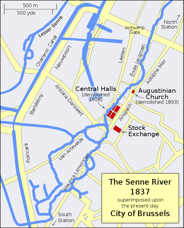
| 16 jan 2008 05:39 |  | 1.416 × 1.750 (104 kB) | MapMaster | == Summary == {{Information |Description=A map showing the course of the Senne River in 1837 superimposed upon the present-day streets of Brussels, including some landmarks |Source=self-made |Date=Today |Author= MapMaster |Permission= | |
Bestandsgebruik
Dit bestand wordt op de volgende pagina gebruikt:
Globaal bestandsgebruik
De volgende andere wiki's gebruiken dit bestand:
- Gebruikt op da.wikipedia.org
- Gebruikt op en.wikipedia.org
- Gebruikt op es.wikipedia.org
- Gebruikt op hr.wikipedia.org
- Gebruikt op pl.wikipedia.org
- Gebruikt op pt.wikipedia.org
- Gebruikt op sh.wikipedia.org