
Bestand:DG Ariel Plantation.jpg

Grootte van deze voorvertoning: 750 × 600 pixels. Andere resoluties: 300 × 240 pixels | 600 × 480 pixels | 960 × 768 pixels | 1.280 × 1.024 pixels | 1.500 × 1.200 pixels.
Oorspronkelijk bestand (1.500 × 1.200 pixels, bestandsgrootte: 162 kB, MIME-type: image/jpeg)
| Dit is een bestand van Wikimedia Commons. Onderstaande beschrijving komt van de beschrijving van het bestand daar. |
Beschrijving
| Beschrijving |
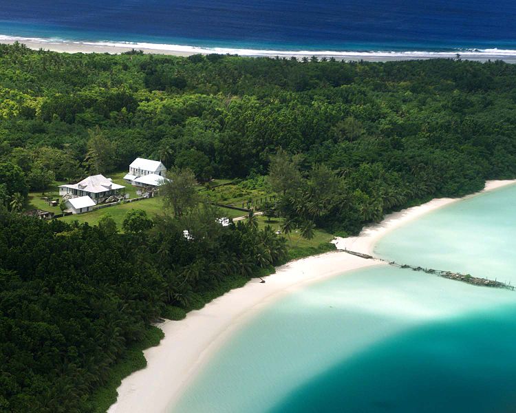
English: Aerial photograph of the coconut plantation at East Point, Diego Garcia. Photograph shows strip of land between both ocean and lagoon.
The island hosts a large airstrip used by the U.S. Armed forces during the Gulf war for operating B-52s. U.S. Submarines and Navy Seal teams have also populated the island in the past. In 1986 The USS Saratoga (CV 60) was docked at the island when it was called away to respond to threats by Lybian Leader Momar Kadaffi and the "Line of Death" in the Gulf of Sidra (also known as the Gulf of Sirte). The carrier left its port while many of its ±4500 sailors were still on the island, which subsequently had to be airlifted via helicopter as the ship made its way to the Mediterranean. The Saratoga spearheaded the assault on the African Nation. |
| Bron | |
| Auteur |
Licentie
Dit werk bevindt zich in het publieke domein in de Verenigde Staten omdat het is vervaardigd door een ambtenaar van de Amerikaanse federale overheid tijdens de uitoefening van zijn functie, en het daarmee volgens Titel 17, Hoofdstuk 1, Sectie 105 van de United States Code [Engelstalige link] een werk van de Amerikaanse federale overheid [Engelstalige link] is.
Nota bene: Het bovenstaande is alleen van toepassing op werken van de federale overheid of een van haar onderdelen, en niet op werken van een afzonderlijk(e) Staat, Territorium, Commonwealth, County, Gemeente, of enig andere bestuurlijke eenheid. Dit sjabloon is ook niet van toepassing op ontwerpen voor postzegels, door de United States Postal Service openbaar gemaakt sinds 1978 [Engelstalige link]. Zie Art. 206.02(b) van "Compendium II: Copyright Office Practices" (Engelstalig).
|
 | |
| Van dit bestand is vastgesteld dat er geen bekende auteursrechtaanspraken op rusten, alle aanverwante en naburige rechten daarbij inbegrepen. | ||
Oorspronkelijk uploadlogboek
De oorspronkelijke beschrijving van deze afbeelding stond hier. Alle volgende gebruikersnamen verwijzen naar en.wikipedia.
- 2005-12-27 07:37 Jgrimmer 1500×1200×8 (166195 bytes) Ariel photograph of the coconut plantation at East Point, Diego Garcia. Photograph shows stip of land between both ocean and lagoon.
Bestandsgeschiedenis
Klik op een datum/tijd om het bestand te zien zoals het destijds was.
| Datum/tijd | Miniatuur | Afmetingen | Gebruiker | Opmerking | |
|---|---|---|---|---|---|
| huidige versie | 20 apr 2008 15:00 | | 1.500 × 1.200 (162 kB) | File Upload Bot (Magnus Manske) | {{BotMoveToCommons|en.wikipedia}} {{Information |Description={{en|Aerial photograph of the coconut plantation at East Point, Diego Garcia. Photograph shows strip of land between both ocean and lagoon. The island hosts a large airstrip used by the U.S. |
Bestandsgebruik
Dit bestand wordt op de volgende pagina gebruikt:
Globaal bestandsgebruik
De volgende andere wiki's gebruiken dit bestand:
- Gebruikt op ast.wikipedia.org
- Gebruikt op be.wikipedia.org
- Gebruikt op ca.wikipedia.org
- Gebruikt op ceb.wikipedia.org
- Gebruikt op cy.wikipedia.org
- Gebruikt op en.wikipedia.org
- Gebruikt op eo.wikipedia.org
- Gebruikt op es.wikipedia.org
- Gebruikt op fa.wikipedia.org
- Gebruikt op fr.wikipedia.org
- Gebruikt op ga.wikipedia.org
- Gebruikt op gl.wikipedia.org
- Gebruikt op he.wikipedia.org
- Gebruikt op hi.wikipedia.org
- Gebruikt op it.wikipedia.org
- Gebruikt op mk.wikipedia.org
- Gebruikt op ml.wikipedia.org
- Gebruikt op mn.wikipedia.org
- Gebruikt op ne.wikipedia.org
- Gebruikt op no.wikipedia.org
- Gebruikt op os.wikipedia.org
- Gebruikt op pt.wikipedia.org
- Gebruikt op sh.wikipedia.org
- Gebruikt op simple.wikipedia.org
- Gebruikt op sr.wikipedia.org
- Gebruikt op ta.wikipedia.org
- Gebruikt op uk.wikipedia.org
- Gebruikt op www.wikidata.org
- Gebruikt op zh.wikipedia.org