
Bestand:Districts and tehsils of Pakistan.png

Grootte van deze voorvertoning: 635 × 599 pixels. Andere resoluties: 254 × 240 pixels | 509 × 480 pixels | 814 × 768 pixels | 1.085 × 1.024 pixels | 1.496 × 1.412 pixels.
Oorspronkelijk bestand (1.496 × 1.412 pixels, bestandsgrootte: 76 kB, MIME-type: image/png)
| Dit is een bestand van Wikimedia Commons. Onderstaande beschrijving komt van de beschrijving van het bestand daar. |

|
Bestand:Map of Pakistan (2017).svg is een vectorversie van dit bestand. Indien niet van slechtere kwaliteit dient deze gebruikt te worden in plaats van deze rasterafbeelding.
File:Districts and tehsils of Pakistan.png → File:Map of Pakistan (2017).svg
Zie Help:SVG voor meer informatie. |
.svg) |
|
|
Bestand:Map of Pakistan (2018).svg is een vectorversie van dit bestand. Indien niet van slechtere kwaliteit dient deze gebruikt te worden in plaats van deze rasterafbeelding.
File:Districts and tehsils of Pakistan.png → File:Map of Pakistan (2018).svg
Zie Help:SVG voor meer informatie. |
.svg) |
Beschrijving
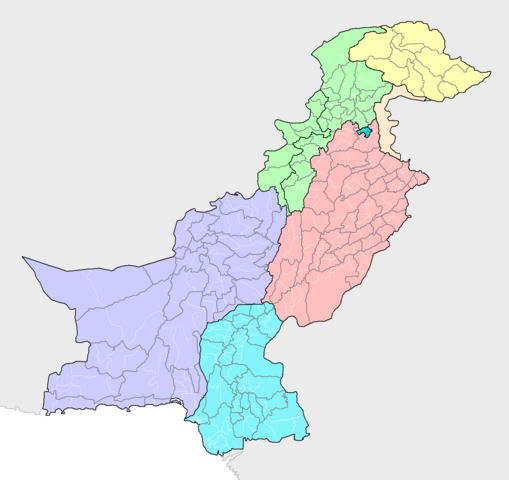
| Beschrijving | Map of the districts of Pakistan, with their constituent tehsils (thin white borders). Map includes the disputed areas. Created by Rarelibra 20:47, 31 October 2007 (UTC) for public domain use, using MapInfo Professional v8.5 and various mapping resources. |
| Datum | 31 oktober 2007 (originele uploaddatum) |
| Bron | Eigen werk |
| Auteur | Rarelibra |
Licentie
| Ik, de auteursrechthebbende van dit werk, geef dit werk vrij in het publieke domein. Dit is wereldwijd van toepassing. In sommige landen is dit wettelijk niet mogelijk; in die gevallen geldt: Ik sta iedereen toe dit werk voor eender welk doel te gebruiken, zonder enige voorwaarden, tenzij zulke voorwaarden door de wet worden voorgeschreven. |
Bestandsgeschiedenis
Klik op een datum/tijd om het bestand te zien zoals het destijds was.
| Datum/tijd | Miniatuur | Afmetingen | Gebruiker | Opmerking | |
|---|---|---|---|---|---|
| huidige versie | 9 mei 2019 23:16 | | 1.496 × 1.412 (76 kB) | Milenioscuro | recolored, cut out leftover areas |
| 13 jun 2018 12:44 |  | 2.112 × 1.632 (110 kB) | Balti sahib | Added the districts of Northern Pakistan (G-baltista), also included Fata into KPK province as per administeratives changes because of Fata Reforms; which merged Fata into KPK province. | |
| 8 aug 2010 18:14 |  | 2.112 × 1.632 (138 kB) | AnonyLog | Aksai Chin is not claimed by Pakistan; this is too complicated to have as currently represented. Also indicates to a newcomer to Pakistan that it administers all of J&K as one district!.. | |
| 13 nov 2009 15:03 |  | 2.112 × 1.632 (142 kB) | Nomi887 | Added Disputed Kashmir Regions and also added colours for more clarity. | |
| 31 okt 2007 22:47 |  | 2.112 × 1.632 (72 kB) | Rarelibra | Map of the tehsils of Pakistan. Map includes the disputed areas. Created by ~~~~ for public domain use, using MapInfo Professional v8.5 and various mapping resources. |
Bestandsgebruik
Dit bestand wordt op de volgende pagina gebruikt:
Globaal bestandsgebruik
De volgende andere wiki's gebruiken dit bestand:
- Gebruikt op ar.wikipedia.org
- Gebruikt op awa.wikipedia.org
- Gebruikt op ba.wikipedia.org
- Gebruikt op be-tarask.wikipedia.org
- Gebruikt op bg.wikipedia.org
- Gebruikt op bn.wikipedia.org
- Gebruikt op bxr.wikipedia.org
- Gebruikt op diq.wikipedia.org
- Gebruikt op dty.wikipedia.org
- Gebruikt op en.wikipedia.org
- Gebruikt op fa.wikipedia.org
- Gebruikt op gl.wikipedia.org
- Gebruikt op hi.wikipedia.org
- Gebruikt op incubator.wikimedia.org
- Gebruikt op inh.wikipedia.org
- Gebruikt op it.wikipedia.org
- Gebruikt op ka.wikipedia.org
- Gebruikt op lez.wikipedia.org
- Gebruikt op mai.wikipedia.org
- Gebruikt op ms.wikipedia.org
- Gebruikt op new.wikipedia.org
- Gebruikt op pa.wikipedia.org
- Gebruikt op pnb.wikipedia.org
- Gebruikt op ps.wikipedia.org
- Gebruikt op pt.wikipedia.org
- Gebruikt op ru.wikipedia.org
- Gebruikt op sd.wikipedia.org
- Gebruikt op simple.wikipedia.org
- Gebruikt op tg.wikipedia.org
- Gebruikt op tl.wikipedia.org
- Gebruikt op uk.wikipedia.org
- Gebruikt op ur.wikipedia.org
Globaal gebruik van dit bestand bekijken.