
Bestand:Europe 1360.jpg
Grootte van deze voorvertoning: 800 × 493 pixels. Andere resoluties: 320 × 197 pixels | 640 × 394 pixels | 1.024 × 631 pixels | 1.280 × 789 pixels | 1.817 × 1.120 pixels.
Oorspronkelijk bestand (1.817 × 1.120 pixels, bestandsgrootte: 695 kB, MIME-type: image/jpeg)
| Dit is een bestand van Wikimedia Commons. Onderstaande beschrijving komt van de beschrijving van het bestand daar. |
Beschrijving
| Beschrijving |
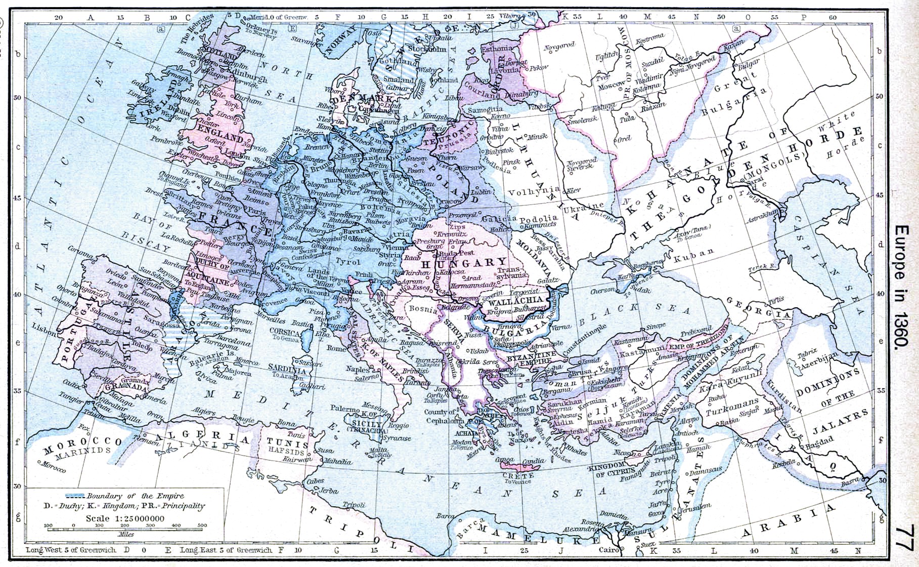
English: Europe in 1360. |
||||||||||||||||||||||
| Datum | |||||||||||||||||||||||
| Bron | http://www.lib.utexas.edu/maps/historical/shepherd/europe_1360.jpg | ||||||||||||||||||||||
| Auteur |
|
||||||||||||||||||||||
| Andere versies | Afgeleide werken van dit bestand: | ||||||||||||||||||||||
.jpg)
_en.png)
.png)
.jpg)
Licentie
|
De auteur overleed in 1934, dus dit werk bevindt zich in het publiek domein in landen en gebieden waar de auteursrechttermijn het leven van de auteur plus 80 jaar of minder is. Dit werk bevindt zich in het publiek domein in de Verenigde Staten omdat het gepubliceerd werd (of geregistreerd bij de U.S. Copyright Office) voor 1 januari 1929. | |
| Van dit bestand is vastgesteld dat er geen bekende auteursrechtaanspraken op rusten, alle aanverwante en naburige rechten daarbij inbegrepen. | |
Bestandsgeschiedenis
Klik op een datum/tijd om het bestand te zien zoals het destijds was.
| Datum/tijd | Miniatuur | Afmetingen | Gebruiker | Opmerking | |
|---|---|---|---|---|---|
| huidige versie | 24 apr 2009 22:51 | | 1.817 × 1.120 (695 kB) | Alex:D | contrast |
| 8 mei 2006 12:31 |  | 1.817 × 1.120 (424 kB) | Roke~commonswiki | Europe in 1360 {{Europe}} {{PD-PCL|http://www.lib.utexas.edu/maps/historical/shepherd/europe_1360.jpg}} Category: Historical maps of Europe |
Bestandsgebruik
Dit bestand wordt op de volgende pagina gebruikt:
Globaal bestandsgebruik
De volgende andere wiki's gebruiken dit bestand:
- Gebruikt op ar.wikipedia.org
- Gebruikt op azb.wikipedia.org
- Gebruikt op bg.wikipedia.org
- Gebruikt op ca.wikipedia.org
- Gebruikt op da.wikipedia.org
- Gebruikt op en.wikipedia.org
- Gebruikt op es.wikipedia.org
- Gebruikt op fa.wikipedia.org
- Gebruikt op fr.wikipedia.org
- Gebruikt op hr.wikipedia.org
- Gebruikt op hy.wikipedia.org
- Gebruikt op id.wikipedia.org
- Gebruikt op it.wikipedia.org
- Gebruikt op nrm.wikipedia.org
- Gebruikt op pl.wikipedia.org
- Gebruikt op scn.wikipedia.org
- Gebruikt op sh.wikipedia.org
- Gebruikt op sr.wikipedia.org
- Gebruikt op vi.wikipedia.org