
Bestand:First Republic of Armenia in 1918-1920.png

Grootte van deze voorvertoning: 799 × 348 pixels. Andere resoluties: 320 × 139 pixels | 640 × 279 pixels | 1.024 × 446 pixels | 1.280 × 558 pixels | 2.560 × 1.115 pixels | 8.192 × 3.568 pixels.
Oorspronkelijk bestand (8.192 × 3.568 pixels, bestandsgrootte: 14,85 MB, MIME-type: image/png)
| Dit is een bestand van Wikimedia Commons. Onderstaande beschrijving komt van de beschrijving van het bestand daar. |
Beschrijving
| Beschrijving |
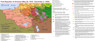
English: The First Republic of Armenia in 1918-1920. |
| Datum | |
| Bron | Eigen werk |
| Auteur | Accipite7 |
Licentie
Ik, de auteursrechthebbende van dit werk, maak het hierbij onder de volgende licentie beschikbaar:
Dit bestand is gelicenseerd onder de Creative Commons Naamsvermelding-GelijkDelen 4.0 Internationaal licentie.
- De gebruiker mag:
- Delen – het werk kopiëren, verspreiden en doorgeven
- Remixen – afgeleide werken maken
- Onder de volgende voorwaarden:
- naamsvermelding – U moet op een gepaste manier aan naamsvermelding doen, een link naar de licentie geven, en aangeven of er wijzigingen in het werk zijn aangebracht. U mag dit op elke redelijke manier doen, maar niet zodanig dat de indruk wordt gewekt dat de licentiegever instemt met uw werk of uw gebruik van zijn werk.
- Gelijk delen – Als u het werk heeft geremixt, veranderd, of erop heeft voortgebouwd, moet u het gewijzigde materiaal verspreiden onder dezelfde licentie als het oorspronkelijke werk, of een daarmee compatibele licentie.
Bestandsgeschiedenis
Klik op een datum/tijd om het bestand te zien zoals het destijds was.
| Datum/tijd | Miniatuur | Afmetingen | Gebruiker | Opmerking | |
|---|---|---|---|---|---|
| huidige versie | 2 jun 2021 17:13 | | 8.192 × 3.568 (14,85 MB) | Accipite7 | for the convenience of viewing small details, the size is increased, the colors are improved |
| 25 mei 2021 10:17 |  | 4.096 × 1.784 (3,69 MB) | Accipite7 | The border between Nahang of Shirak and Nahang of Syunik has been clarified. | |
| 21 mei 2021 11:59 |  | 4.096 × 1.784 (3,7 MB) | Accipite7 | The temporary border between the Republic of Armenia and the Soviet republics (August 10, 1920) in the Nakhichevan county has been clarified. Added a legend marked on the map under the number 26. | |
| 13 mei 2021 10:35 |  | 4.096 × 1.784 (3,97 MB) | Accipite7 | fixed typo | |
| 13 mei 2021 10:27 |  | 4.096 × 1.784 (3,97 MB) | Accipite7 | The names of the types of administrative units of the former Russian Empire have been clarified: uyezd = county, okrug = district, oblast = territory, guberniya = governorate. | |
| 12 mei 2021 13:14 |  | 4.096 × 1.784 (3,71 MB) | Accipite7 | Corrected data in the map legend regarding what is indicated on the map by numbers. Clarified the boundaries of the territories required at the Paris Peace Conference. I strongly ask the user of Culminatio not to vandalize and not return the map to the version on which he marked the line reached as a result of the Turkish offensive in 1920. Since, firstly, it is neural: Batumi, Artvin and Ardahan were under the control of the Democratic Republic of Georgia until February-March 1921. And secon... | |
| 12 mei 2021 06:13 |  | 5.375 × 2.341 (7,18 MB) | Culminatio | Reverted to version as of 15:05, 8 May 2021 (UTC) | |
| 11 mei 2021 09:11 |  | 4.096 × 1.784 (3,99 MB) | Accipite7 | The boundaries of the territory of the demands of the Armenian delegation in the Transcaucasus, submitted to the Paris Peace Conference of 1919, were clarified. There is no need to overload the map with the line reached by the Turkish forces in 1920, as the map already shows the results of the Armenian-Turkish war of 1920 - the border according to the Treaty of Alexandropol, December 2, 1920 | |
| 8 mei 2021 17:05 |  | 5.375 × 2.341 (7,18 MB) | Culminatio | Additional line of the turkish advance on the northern positions during the war of 1920. Additional numbers 10,19,20,21 on the map. | |
| 8 mei 2021 12:49 |  | 6.336 × 2.760 (2,21 MB) | Accipite7 | Improved colors. |
Bestandsgebruik
Dit bestand wordt op de volgende pagina gebruikt:
Globaal bestandsgebruik
De volgende andere wiki's gebruiken dit bestand:
- Gebruikt op az.wikipedia.org
- Gebruikt op be.wikipedia.org
- Gebruikt op bg.wikipedia.org
- Gebruikt op de.wikipedia.org
- Gebruikt op el.wikipedia.org
- Gebruikt op fi.wikipedia.org
- Gebruikt op fr.wikipedia.org
- Gebruikt op hy.wikipedia.org
- Gebruikt op it.wikipedia.org
- Gebruikt op pl.wikipedia.org
- Gebruikt op pt.wikipedia.org
- Gebruikt op ro.wikipedia.org
- Gebruikt op ru.wikipedia.org
- Gebruikt op sr.wikipedia.org
- Gebruikt op uk.wikipedia.org
- Gebruikt op zh.wikipedia.org