
Bestand:Grid parity map.svg

Oorspronkelijk bestand (SVG-bestand, nominaal 940 × 470 pixels, bestandsgrootte: 2,03 MB)
| Dit is een bestand van Wikimedia Commons. Onderstaande beschrijving komt van de beschrijving van het bestand daar. |
Beschrijving
| Beschrijving |
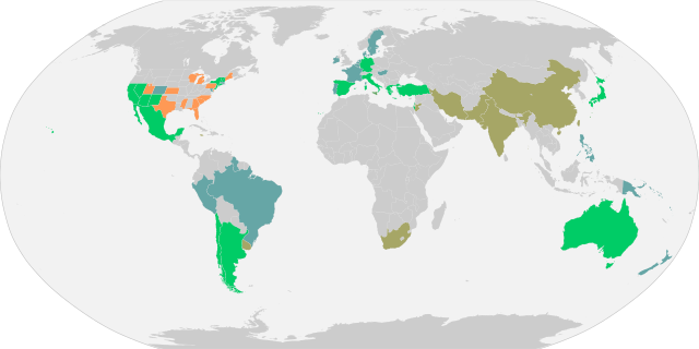
English: Countries where solar PV achieved grid parity (residential, industrial or commercial). A more detailed enumeration by state is given for the United States. Calculations do not account for any subsidies. As of 2015, roughly 30 countries are at grid parity out of our sample size of over 60 countries under review by the Deutsche Bank Market Research group (see sources below). ▇ Reached grid-parity before 2014
U.S. states at grid parity as of 2015 include Arizona, California, Connecticut, Hawaii, Nevada, New Hampshire, New Jersey, New Mexico, New York, and Vermont. Countries at grid parity for peak electricity prices (during peak electricity demand) as of 2015 include China and its autonomous territory of Hong Kong, Taiwan, India, Iran, Jamaica, Jordan, Pakistan, South Africa, United States, and Uruguay. |
| Datum | |
| Bron |
Eigen werk.
|
| Auteur | Sandegud. Based on this blank map in public domain |
Licentie
| Dit bestand is beschikbaar onder Creative Commons CC0 1.0 Universele Public Domain Dedication. | |
| De persoon die een werk voorziet van deze licentie stelt dit werk beschikbaar aan het publieke domein door, voor zover dit wettelijk is toegestaan, afstand te doen van alle rechten op het werk in de zin van het auteursrecht, met inbegrip van alle aanverwante of naburige rechten. U kunt het werk kopiëren, aanpassen, distribueren en uitvoeren, ook voor commerciële doeleinden, zonder dat u daarvoor toestemming hoeft te vragen.
|
Bestandsgeschiedenis
Klik op een datum/tijd om het bestand te zien zoals het destijds was.
| Datum/tijd | Miniatuur | Afmetingen | Gebruiker | Opmerking | |
|---|---|---|---|---|---|
| huidige versie | 29 jun 2015 19:12 | | 940 × 470 (2,03 MB) | Rfassbind | Updated map with 2015-edition of Deutsche Bank report. Differentiated colors (see legend in file description). Fixed some map bugs. Removed opacity causing color variations. Fixed US-Great Lakes. |
| 20 mei 2015 09:58 |  | 940 × 470 (2,03 MB) | Sandegud | us states | |
| 20 mei 2015 09:43 |  | 940 × 470 (2,03 MB) | Sandegud | User created page with UploadWizard |
Bestandsgebruik
Dit bestand wordt op de volgende pagina gebruikt:
Globaal bestandsgebruik
De volgende andere wiki's gebruiken dit bestand:
- Gebruikt op ar.wikipedia.org
- Gebruikt op en.wikipedia.org
- Gebruikt op es.wikipedia.org
- Gebruikt op fr.wikipedia.org
- Gebruikt op pt.wikipedia.org
- Gebruikt op ru.wikipedia.org