
Bestand:Holy Alliance.png
Geen hogere resolutie beschikbaar.
Holy_Alliance.png (262 × 197 pixels, bestandsgrootte: 4 kB, MIME-type: image/png)
| Dit is een bestand van Wikimedia Commons. Onderstaande beschrijving komt van de beschrijving van het bestand daar. |

|
Bestand:Map of the Holy Alliance (1840).svg is een vectorversie van dit bestand. Indien niet van slechtere kwaliteit dient deze gebruikt te worden in plaats van deze rasterafbeelding.
File:Holy Alliance.png → File:Map of the Holy Alliance (1840).svg
Zie Help:SVG voor meer informatie. |
.svg) |
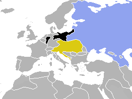
| Beschrijving | Map of Europe, highlighting the Holy Alliance of 1815 | ||
| Datum | (UTC) | ||
| Bron | Cropped and colourised from Image:BlankMap-World-1840.png | ||
| Auteur | OwenBlacker | ||
| Toestemming (Hergebruik van dit bestand) |
|
Bestandsgeschiedenis
Klik op een datum/tijd om het bestand te zien zoals het destijds was.
| Datum/tijd | Miniatuur | Afmetingen | Gebruiker | Opmerking | |
|---|---|---|---|---|---|
| huidige versie | 2 aug 2009 17:01 | | 262 × 197 (4 kB) | Berillium | Reverted to version as of 14:59, 17 November 2007 merges |
| 2 aug 2009 03:04 |  | 262 × 197 (6 kB) | Buonaparte69~commonswiki | Russia change to traditional 19th-century colour of green. | |
| 17 nov 2007 16:59 |  | 262 × 197 (4 kB) | OwenBlacker | Correction: I'd forgotten to colourise the Rhenish exclave of Prussia | |
| 18 okt 2007 23:19 |  | 262 × 197 (4 kB) | OwenBlacker | {{Information |Description=Map of Europe, highlighting the Holy Alliance of 1815 |Source=Cropped and colourised from Image:BlankMap-World-1840.png |Date=~~~~~ |Author=~~~ |other_versions= |Licencing={{PD-user-w|en|Engli |
Bestandsgebruik
Geen enkele pagina gebruikt dit bestand.
Globaal bestandsgebruik
De volgende andere wiki's gebruiken dit bestand:
- Gebruikt op en.wikipedia.org
- Gebruikt op zh.wikipedia.org