
Bestand:Interstate 74 map.png

Grootte van deze voorvertoning: 800 × 450 pixels. Andere resoluties: 320 × 180 pixels | 640 × 360 pixels | 1.024 × 575 pixels | 1.280 × 719 pixels | 2.205 × 1.239 pixels.
Oorspronkelijk bestand (2.205 × 1.239 pixels, bestandsgrootte: 94 kB, MIME-type: image/png)
| Dit is een bestand van Wikimedia Commons. Onderstaande beschrijving komt van de beschrijving van het bestand daar. |
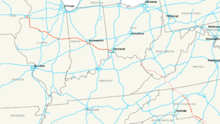
| Beschrijving | Map of Interstate 74 |
| Datum | |
| Bron | Eigen werk |
| Auteur | Nick Nolte |
| Toestemming (Hergebruik van dit bestand) |
Own work, all rights released (Public domain) |
Ik, de auteursrechthebbende van dit werk, maak het hierbij onder de volgende licentie beschikbaar:
| Dit bestand is beschikbaar onder Creative Commons CC0 1.0 Universele Public Domain Dedication. | |
| De persoon die een werk voorziet van deze licentie stelt dit werk beschikbaar aan het publieke domein door, voor zover dit wettelijk is toegestaan, afstand te doen van alle rechten op het werk in de zin van het auteursrecht, met inbegrip van alle aanverwante of naburige rechten. U kunt het werk kopiëren, aanpassen, distribueren en uitvoeren, ook voor commerciële doeleinden, zonder dat u daarvoor toestemming hoeft te vragen.
|
Bestandsgeschiedenis
Klik op een datum/tijd om het bestand te zien zoals het destijds was.
| Datum/tijd | Miniatuur | Afmetingen | Gebruiker | Opmerking | |
|---|---|---|---|---|---|
| huidige versie | 24 jun 2017 19:14 | | 2.205 × 1.239 (94 kB) | Roadsguy | Updated to include current progress between Ellerbe and Winston-Salem, as well as more accurate routing of the proposed section along US 52 and the future Winston-Salem Northern Beltway. |
| 11 dec 2008 07:45 |  | 2.205 × 1.239 (155 kB) | MPD01605~commonswiki | Updated to include new sections of I-74 in North Carolina, also added pink shading for future route except in Ohio, as I could not find anything to solifify that route. | |
| 16 jul 2006 07:15 |  | 2.205 × 1.239 (159 kB) | Stratosphere | {{Information| |Description=Map of Interstate 74 |Source=Own Work |Date=July 15, 2006 |Author=Nick Nolte |Permission=Own work, all rights released (Public domain) |other_versions= }} {{PD-self}} Category:U.S. Interstate Maps[ |
Bestandsgebruik
Dit bestand wordt op de volgende pagina gebruikt:
Globaal bestandsgebruik
De volgende andere wiki's gebruiken dit bestand:
- Gebruikt op de.wikipedia.org
- Gebruikt op eu.wikipedia.org
- Gebruikt op fa.wikipedia.org
- Gebruikt op fr.wikipedia.org
- Gebruikt op ko.wikipedia.org
- Gebruikt op lmo.wikipedia.org
- Gebruikt op ru.wikipedia.org
- Gebruikt op sv.wikipedia.org
- Gebruikt op vi.wikipedia.org
- Gebruikt op www.wikidata.org
- Gebruikt op zh.wikipedia.org