
Bestand:Israel Railway Map.png

Grootte van deze voorvertoning: 369 × 599 pixels. Andere resoluties: 148 × 240 pixels | 295 × 480 pixels | 473 × 768 pixels | 1.243 × 2.018 pixels.
Oorspronkelijk bestand (1.243 × 2.018 pixels, bestandsgrootte: 277 kB, MIME-type: image/png)
| Dit is een bestand van Wikimedia Commons. Onderstaande beschrijving komt van de beschrijving van het bestand daar. |
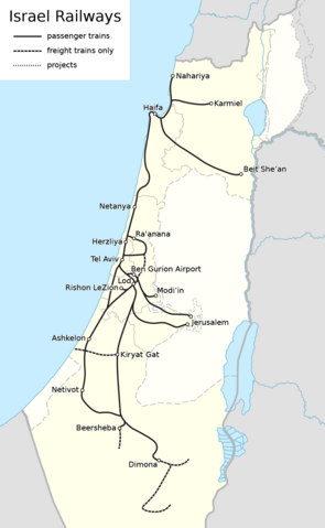
| Beschrijving |
|
| Datum | see file history |
| Bron | Eigen werk, using this file by NordNordWest as background |
| Auteur | Maximilian Dörrbecker (Chumwa) |
| Toestemming (Hergebruik van dit bestand) |
Ik, de auteursrechthebbende van dit werk, maak het hierbij onder de volgende licentie beschikbaar: Dit bestand is gelicenseerd onder de Creative Commons-licentie Naamsvermelding-Gelijk delen 2.5 Unported
Sie dürfen das Bild zu den folgenden Bedingungen nutzen:
|
Bestandsgeschiedenis
Klik op een datum/tijd om het bestand te zien zoals het destijds was.
| Datum/tijd | Miniatuur | Afmetingen | Gebruiker | Opmerking | |
|---|---|---|---|---|---|
| huidige versie | 2 sep 2020 11:28 | | 1.243 × 2.018 (277 kB) | Crash48 | Ra'anana loop complete; mark Kiryat Gat junction |
| 17 nov 2018 21:47 |  | 1.243 × 2.018 (248 kB) | Chumwa | update | |
| 21 mrt 2018 22:38 |  | 1.243 × 2.018 (246 kB) | Chumwa | update | |
| 29 mrt 2016 23:01 |  | 1.243 × 2.018 (247 kB) | Chumwa | {{Information |Description= *{{de|Karte Eisenbahnnetz Israel}} *{{en|Map of the Railways in Israel}} |Source={{Own}}, using this file by {{U|NordNordWest}} as background |Date=see file history |Author= [[:de:User:Chumw... |
Bestandsgebruik
Dit bestand wordt op de volgende pagina gebruikt:
Globaal bestandsgebruik
De volgende andere wiki's gebruiken dit bestand:
- Gebruikt op de.wikipedia.org
- Gebruikt op fr.wikipedia.org
- Gebruikt op fr.wikivoyage.org
- Gebruikt op ja.wikipedia.org
- Gebruikt op ko.wikipedia.org
- Gebruikt op mk.wikipedia.org
- Gebruikt op no.wikipedia.org
- Gebruikt op pl.wikipedia.org
- Gebruikt op pt.wikipedia.org
- Gebruikt op www.wikidata.org