
Bestand:K129 HGE recoverysite.png
Grootte van deze voorvertoning: 610 × 600 pixels. Andere resoluties: 244 × 240 pixels | 488 × 480 pixels | 657 × 646 pixels.
Oorspronkelijk bestand (657 × 646 pixels, bestandsgrootte: 53 kB, MIME-type: image/png)
| Dit is een bestand van Wikimedia Commons. Onderstaande beschrijving komt van de beschrijving van het bestand daar. |
Beschrijving
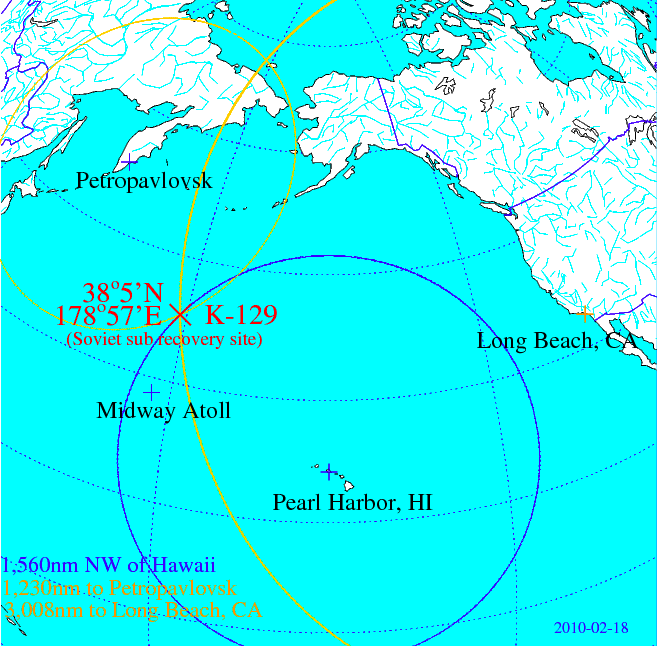
| Beschrijving | Map depicting the location of K-129 (Soviet Golf II class strategic ballistic missile submarine), which was (partially?) recovered by the USNS Hughes Glomar Explorer |
| Datum | |
| Bron | Own work, based on FOIA release specifying distance of recovery site to Long Beach, CA, and Hawaii, respectively. |
| Auteur | Enemenemu |
Licentie
| Ik, de auteursrechthebbende van dit werk, geef dit werk vrij in het publieke domein. Dit is wereldwijd van toepassing. In sommige landen is dit wettelijk niet mogelijk; in die gevallen geldt: Ik sta iedereen toe dit werk voor eender welk doel te gebruiken, zonder enige voorwaarden, tenzij zulke voorwaarden door de wet worden voorgeschreven. |
Bestandsgeschiedenis
Klik op een datum/tijd om het bestand te zien zoals het destijds was.
| Datum/tijd | Miniatuur | Afmetingen | Gebruiker | Opmerking | |
|---|---|---|---|---|---|
| huidige versie | 9 apr 2015 00:03 | | 657 × 646 (53 kB) | RokerHRO | optipng -o7 -i0 → 48.98% decrease |
| 19 feb 2010 01:41 |  | 657 × 646 (104 kB) | Enemenemu | Added location of Midway Atoll to map | |
| 19 feb 2010 00:07 |  | 659 × 638 (102 kB) | Enemenemu | Added home port distance to accident site, and updated coordinates of recovery site slightly | |
| 18 feb 2010 00:08 |  | 735 × 736 (47 kB) | Enemenemu | {{Information |Description=Map depicting the location of K-129 (Soviet Golf II class strategic ballistic missile submarine), which was (partially?) recovered by the USNS Hughes Glomar Explorer |Source=Own work, based on FOIA release specifying distance of |
Bestandsgebruik
Dit bestand wordt op de volgende pagina gebruikt:
Globaal bestandsgebruik
De volgende andere wiki's gebruiken dit bestand:
- Gebruikt op be.wikipedia.org
- Gebruikt op cs.wikipedia.org
- Gebruikt op de.wikipedia.org
- Gebruikt op en.wikipedia.org
- Gebruikt op es.wikipedia.org
- Gebruikt op fi.wikipedia.org
- Gebruikt op fr.wikipedia.org
- Gebruikt op he.wikipedia.org
- Gebruikt op it.wikipedia.org
- Gebruikt op ru.wikipedia.org
- Gebruikt op uz.wikipedia.org