
Bestand:Karta ID RajaAmpat Isl.PNG
Geen hogere resolutie beschikbaar.
Karta_ID_RajaAmpat_Isl.PNG (450 × 600 pixels, bestandsgrootte: 19 kB, MIME-type: image/png)
| Dit is een bestand van Wikimedia Commons. Onderstaande beschrijving komt van de beschrijving van het bestand daar. |
Beschrijving
| Beschrijving |
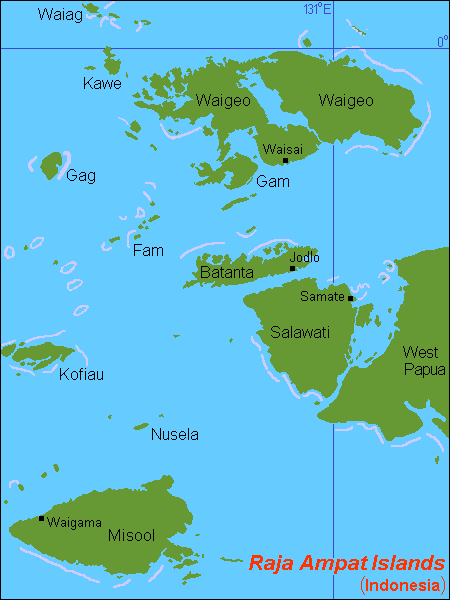
English: Map (rough) of Raja Ampat islands, Indonesia, own work composed from various mapreferences |
| Datum | |
| Bron | Eigen werk |
| Auteur | Hobe / Holger Behr |
Licentie
| Dit werk vrijgegeven in het publieke domein door de auteur, I, Hobe. Dit is wereldwijd van toepassing. In sommige landen is dit wettelijk niet mogelijk; in die gevallen geldt: I, Hobe staat iedereen toe dit werk voor eender welk doel te gebruiken, zonder enige voorwaarden, tenzij zulke voorwaarden door de wet worden voorgeschreven. |
Bestandsgeschiedenis
Klik op een datum/tijd om het bestand te zien zoals het destijds was.
| Datum/tijd | Miniatuur | Afmetingen | Gebruiker | Opmerking | |
|---|---|---|---|---|---|
| huidige versie | 19 jun 2023 13:01 | | 450 × 600 (19 kB) | Hobe | higher accuracy |
| 8 jul 2007 20:00 |  | 450 × 600 (21 kB) | Hobe | {{Information |Description=map Raja Ampat islands, Indonesia |Source=self-made, composed from various mapreferences |Date=2007-07-07 |Author= Hobe Category:Maps of Indonesia }} |
Bestandsgebruik
Dit bestand wordt op de volgende 7 pagina's gebruikt:
Globaal bestandsgebruik
De volgende andere wiki's gebruiken dit bestand:
- Gebruikt op ar.wikipedia.org
- Gebruikt op arz.wikipedia.org
- Gebruikt op ast.wikipedia.org
- Gebruikt op az.wikipedia.org
- Gebruikt op bg.wikipedia.org
- Gebruikt op bm.wikipedia.org
- Gebruikt op bn.wikipedia.org
- Gebruikt op ca.wikipedia.org
- Gebruikt op ceb.wikipedia.org
- Gebruikt op cs.wikipedia.org
- Gebruikt op cv.wikipedia.org
- Gebruikt op de.wikipedia.org
Globaal gebruik van dit bestand bekijken.