
Bestand:Klamath Mountains map.gif
Grootte van deze voorvertoning: 451 × 599 pixels. Andere resoluties: 181 × 240 pixels | 515 × 684 pixels.
Oorspronkelijk bestand (515 × 684 pixels, bestandsgrootte: 33 kB, MIME-type: image/gif)
| Dit is een bestand van Wikimedia Commons. Onderstaande beschrijving komt van de beschrijving van het bestand daar. |
Beschrijving
| Beschrijving |
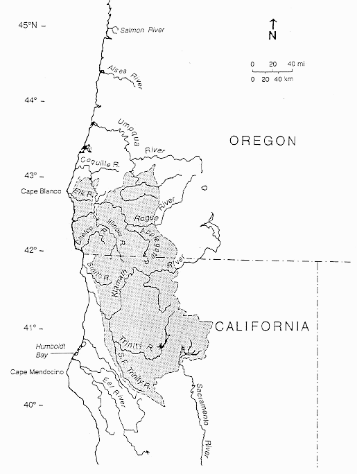
English: Map of the Klamath Mountains Geologic Province (shaded).
|
| Datum | (original creation) |
| Bron | [1] |
| Auteur | U.S. Geological Survey, California Division of Mines and Geology and NOAA, Northwest Fisheries Science Center |
| Toestemming (Hergebruik van dit bestand) |
NOAA source credits map to: "Irwin, W. P. 1966. Geology of the Klamath Mountains Province. In E. H. Bailey (editor), Geology of northern California, p. 19-38. U.S. Geological Survey, California Division of Mines and Geology, Bulletin 190." [2] |
Licentie
Deze afbeelding bevindt zich in het publiek domein omdat het materiaal bevat dat oorspronkelijk afkomstig is van de United States Geological Survey, een agentschap van de United States Department of the Interior. Voor meer informatie, zie het officiële USGS-auteursrechtenbeleid
|
Bestandsgeschiedenis
Klik op een datum/tijd om het bestand te zien zoals het destijds was.
| Datum/tijd | Miniatuur | Afmetingen | Gebruiker | Opmerking | |
|---|---|---|---|---|---|
| huidige versie | 26 aug 2015 23:54 | | 515 × 684 (33 kB) | Jsayre64 | slight crop |
| 11 dec 2011 21:20 |  | 525 × 720 (36 kB) | Jsayre64 | {{Information |Description ={{en|1=Map of Oregon and California, with the Klamath Mountains shaded}} |Source =[http://www.nwfsc.noaa.gov/publications/techmemos/tm19/tm19.html?CFID=4870317&CFTOKEN=44479674&jsessionid=843044b4a22c3654c5db2a796b5d |
Bestandsgebruik
Dit bestand wordt op de volgende 2 pagina's gebruikt:
Globaal bestandsgebruik
De volgende andere wiki's gebruiken dit bestand:
- Gebruikt op en.wikipedia.org
- Gebruikt op fr.wikipedia.org
- Gebruikt op pl.wikipedia.org