
Bestand:LA County Incorporated Areas Los Angeles highlighted.svg

Afmetingen van deze voorvertoning van het type PNG van dit SVG-bestand: 730 × 599 pixels Andere resoluties: 292 × 240 pixels | 585 × 480 pixels | 935 × 768 pixels | 1.247 × 1.024 pixels | 2.494 × 2.048 pixels | 950 × 780 pixels.
Oorspronkelijk bestand (SVG-bestand, nominaal 950 × 780 pixels, bestandsgrootte: 261 kB)
| Dit is een bestand van Wikimedia Commons. Onderstaande beschrijving komt van de beschrijving van het bestand daar. |
Beschrijving
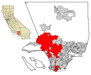
| Beschrijving | This map shows the incorporated areas in Los Angeles County, California. Los Angeles is highlighted in red. I created it in Inkscape using data from the Los Angeles County Website (Los Angeles County Incorporated Area and District Map (PDF). |
| Datum | |
| Bron | My own work, based on public domain information. Though I strove to be as accurate in the detail as possible, the information shown is not guaranteed to be completely accurate. |
| Auteur | Ixnayonthetimmay |
| Toestemming (Hergebruik van dit bestand) |
Public Domain |
| Andere versies | See Category:Maps of Los Angeles County, California for other versions of this image. |
Licentie
| Ik, de auteursrechthebbende van dit werk, geef dit werk vrij in het publieke domein. Dit is wereldwijd van toepassing. In sommige landen is dit wettelijk niet mogelijk; in die gevallen geldt: Ik sta iedereen toe dit werk voor eender welk doel te gebruiken, zonder enige voorwaarden, tenzij zulke voorwaarden door de wet worden voorgeschreven. |
Bestandsgeschiedenis
Klik op een datum/tijd om het bestand te zien zoals het destijds was.
| Datum/tijd | Miniatuur | Afmetingen | Gebruiker | Opmerking | |
|---|---|---|---|---|---|
| huidige versie | 26 jun 2007 09:19 | | 950 × 780 (261 kB) | Ixnayonthetimmay | == Summary == {{Information |Description=This map shows the incorporated areas in Los Angeles County, California. Los Angeles is highlighted in |
Bestandsgebruik
Dit bestand wordt op de volgende 2 pagina's gebruikt:
Globaal bestandsgebruik
De volgende andere wiki's gebruiken dit bestand:
- Gebruikt op af.wikipedia.org
- Gebruikt op als.wikipedia.org
- Gebruikt op ang.wikipedia.org
- Gebruikt op ar.wikipedia.org
- Gebruikt op arz.wikipedia.org
- Gebruikt op ast.wikipedia.org
- Gebruikt op azb.wikipedia.org
- Gebruikt op bg.wikipedia.org
- Gebruikt op bh.wikipedia.org
- Gebruikt op bn.wikipedia.org
- Gebruikt op ca.wikipedia.org
- Gebruikt op chy.wikipedia.org
- Gebruikt op de.wikipedia.org
- Gebruikt op diq.wikipedia.org
- Gebruikt op dty.wikipedia.org
- Gebruikt op el.wikipedia.org
- Gebruikt op en.wikipedia.org
- Los Angeles
- Los Angeles Police Department
- Harbor Gateway, Los Angeles
- Municipal annexation in the United States
- Category:Neighborhoods in Los Angeles
- National Register of Historic Places listings in Los Angeles
- Killing of Ezell Ford
- Wikipedia talk:WikiProject China/Archive 26
- Talk:New York (state)/Archive 7
- User:Hparham865
- User:Nate.beisheim/sandbox10
- Gebruikt op en.wikinews.org
- Gebruikt op es.wikipedia.org
- Gebruikt op eu.wikipedia.org
- Gebruikt op ext.wikipedia.org
- Gebruikt op fa.wikipedia.org
- Gebruikt op fi.wikipedia.org
- Gebruikt op fo.wikipedia.org
- Gebruikt op fr.wikipedia.org
- Los Angeles
- Projet:Charte graphique/Domaine géographique
- Los Angeles Police Department
- Modèle:Infobox Ville des États-Unis
- Modèle:Infobox Ville des États-Unis/Documentation
- Gangster Squad (LAPD)
- Community Resources Against Street Hoodlums
- Division métropolitaine du Los Angeles Police Department
- Modèle:Infobox Ville des États-Unis/Bac à sable
- Gebruikt op fr.wikinews.org
- Gebruikt op fy.wikipedia.org
Globaal gebruik van dit bestand bekijken.