
Bestand:Macedonia 1913 map.png
Geen hogere resolutie beschikbaar.
Macedonia_1913_map.png (600 × 449 pixels, bestandsgrootte: 60 kB, MIME-type: image/png)
| Dit is een bestand van Wikimedia Commons. Onderstaande beschrijving komt van de beschrijving van het bestand daar. |
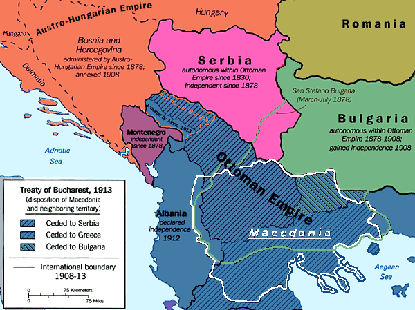
Beschrijving
The geographical region of Macedonia in 1913.
Ocupirana Makedonija od strana na Srbija,Bugarija i Grcija : A Map Folio (U.S. Central Intelligence Agency, 1992)
Originally uploaded by ChrisO at English Wikipedia.
Licentie
| This image is a work of a Central Intelligence Agency employee, taken or made as part of that person's official duties. As a Work of the United States Government, this image or media is in the public domain in the United States.
|

|
Bestandsgeschiedenis
Klik op een datum/tijd om het bestand te zien zoals het destijds was.
| Datum/tijd | Miniatuur | Afmetingen | Gebruiker | Opmerking | |
|---|---|---|---|---|---|
| huidige versie | 22 feb 2019 18:37 | | 600 × 449 (60 kB) | Julieta39 | Cosmetic changes |
| 22 mrt 2005 21:31 |  | 600 × 449 (67 kB) | Karmosin~commonswiki | {{PD}} |
Bestandsgebruik
Dit bestand wordt op de volgende pagina gebruikt:
Globaal bestandsgebruik
De volgende andere wiki's gebruiken dit bestand:
- Gebruikt op da.wikipedia.org
- Gebruikt op de.wikipedia.org
- Gebruikt op en.wikipedia.org
- Gebruikt op eu.wikipedia.org
- Gebruikt op fr.wikipedia.org
- Gebruikt op it.wikipedia.org
- Gebruikt op ja.wikipedia.org
- Gebruikt op la.wikipedia.org
- Gebruikt op mk.wikipedia.org
- Бугарска егзархија
- Букурешки договор (1913)
- Српски комитет на четничката акција
- Елиномакедонски комитет
- Мис Елен Стон
- Странски пропаганди во Македонија
- Бугарско тајно револуционерно братство
- Лазаристи
- Бугарски централен акционен комитет
- Егзархиска групација во Македонија
- Андартска провокација
- Начертание
- Грчка пропаганда во Македонија
- Етники етерија
- Борба за Македонија
- Српска пропаганда во Македонија
- Бугарска пропаганда во Македонија
- Шаблон:Странски пропаганди во Македонија
- Отпор на Македонците кон туѓите пропаганди
- Судир со бугарската пропаганда во врска со решавањето на црковното прашање
- Политичко влијание на Ватикан во Македонија
- Романска пропаганда во Македонија
- Обид за поделба на македонските епархии меѓу Патријаршија и Егзархија
- Македонско движење и српската пропаганда
- Протестантска пропаганда во Македонија
- Второ политичко одделени при Министерство за надворешни работи на Кнежеството Бугарија
- Gebruikt op nds.wikipedia.org
- Gebruikt op no.wikipedia.org
- Gebruikt op sl.wikipedia.org
- Gebruikt op sq.wikipedia.org
- Gebruikt op sv.wikipedia.org
- Gebruikt op uk.wikipedia.org
Globaal gebruik van dit bestand bekijken.