
Bestand:Maryland Campaign.png
Grootte van deze voorvertoning: 531 × 600 pixels. Andere resoluties: 212 × 240 pixels | 425 × 480 pixels | 680 × 768 pixels | 906 × 1.024 pixels | 1.601 × 1.809 pixels.
Oorspronkelijk bestand (1.601 × 1.809 pixels, bestandsgrootte: 576 kB, MIME-type: image/png)
| Dit is een bestand van Wikimedia Commons. Onderstaande beschrijving komt van de beschrijving van het bestand daar. |
Beschrijving
| Beschrijving |
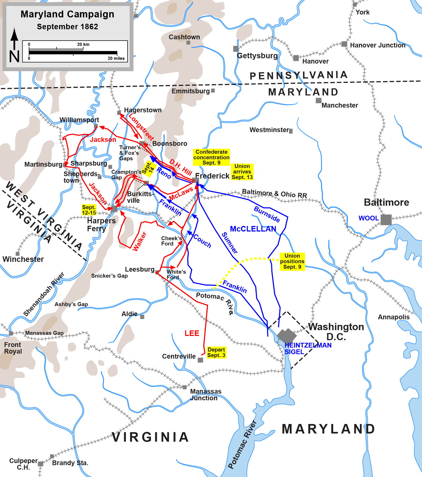
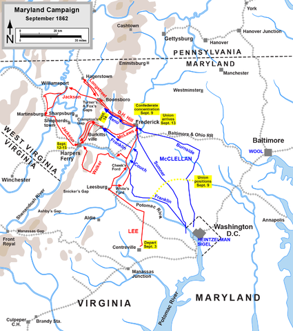
English: Map of the Maryland Campaign of the American Civil War, actions Sept. 3-15. Drawn by Hal Jespersen in Adobe Illustrator CS5. Graphic source file is available at http://www.posix.com/CWmaps/ |
| Datum | (first version); 6 maart 2011 (last version) |
| Bron | http://www.posix.com/CWmaps/Maryland_Campaign.png |
| Auteur | Hal Jespersen at en.wikipedia |
| PNG ontwikkeling | Deze kaart is gemaakt met Adobe Illustrator |
Licentie
| Dit werk vrijgegeven in het publieke domein door de auteur, Hal Jespersen. Dit is wereldwijd van toepassing. In sommige landen is dit wettelijk niet mogelijk; in die gevallen geldt: Hal Jespersen staat iedereen toe dit werk voor eender welk doel te gebruiken, zonder enige voorwaarden, tenzij zulke voorwaarden door de wet worden voorgeschreven.
|

|
Bestand:Maryland Campaign a.svg is een vectorversie van dit bestand. Indien niet van slechtere kwaliteit dient deze gebruikt te worden in plaats van deze rasterafbeelding.
File:Maryland Campaign.png → File:Maryland Campaign a.svg
Zie Help:SVG voor meer informatie. |
 |
Oorspronkelijk uploadlogboek
(All user names refer to en.wikipedia)
- 2006-06-17 16:04 Hlj 1502×1700×8 (540349 bytes) Map of the [[Maryland Campaign]] of the [[American Civil War]], actions Sept. 3-15. Drawn by Hal Jespersen in Macromedia Freehand. Graphic source file is available at http://www.posix.com/CWmaps/
Bestandsgeschiedenis
Klik op een datum/tijd om het bestand te zien zoals het destijds was.
| Datum/tijd | Miniatuur | Afmetingen | Gebruiker | Opmerking | |
|---|---|---|---|---|---|
| huidige versie | 30 mrt 2011 00:46 | | 1.601 × 1.809 (576 kB) | Hlj | Update to graphical format of rivers and roads. |
| 7 mrt 2011 01:07 |  | 1.601 × 1.809 (450 kB) | Innotata | New version from enwiki, uploaded by original uploader. Upload summaries: "Fixed DC boundary. Adobe Illustrator source file at http://www.posix.com/CWmaps/"; "minor graphical changes to conform to style used by most ACW maps; added legend and scale." | |
| 26 apr 2007 04:09 |  | 1.502 × 1.700 (528 kB) | Qbek | {{Information |Description=Map of the en:Maryland Campaign of the en:American Civil War, actions Sept. 3-15. Drawn by Hal Jespersen in Macromedia Freehand. Graphic source file is available at http://www.posix.com/CWmaps/ |Source=Originally from |
Bestandsgebruik
Dit bestand wordt op de volgende 4 pagina's gebruikt:
Globaal bestandsgebruik
De volgende andere wiki's gebruiken dit bestand:
- Gebruikt op azb.wikipedia.org
- Gebruikt op cs.wikipedia.org
- Gebruikt op da.wikipedia.org
- Gebruikt op de.wikipedia.org
- Gebruikt op es.wikipedia.org
- Gebruikt op fa.wikipedia.org
- Gebruikt op fr.wikipedia.org
- Gebruikt op hu.wikipedia.org
- Gebruikt op it.wikipedia.org
- Gebruikt op ja.wikipedia.org
- Gebruikt op ko.wikipedia.org
- Gebruikt op la.wikipedia.org
- Gebruikt op ms.wikipedia.org
- Gebruikt op no.wikipedia.org
- Gebruikt op pl.wikipedia.org
- Gebruikt op pt.wikipedia.org
- Gebruikt op ro.wikipedia.org
- Gebruikt op sr.wikipedia.org
- Gebruikt op vi.wikipedia.org
- Gebruikt op zh.wikipedia.org