
Bestand:Montserrat-CIA WFB Map.png
Geen hogere resolutie beschikbaar.
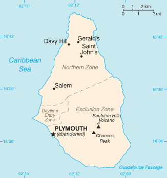
Montserrat-CIA_WFB_Map.png (326 × 349 pixels, bestandsgrootte: 7 kB, MIME-type: image/png)
| Dit is een bestand van Wikimedia Commons. Onderstaande beschrijving komt van de beschrijving van het bestand daar. |
Deze afbeelding bevindt zich in het publiek domein omdat het materiaal bevat dat oorspronkelijk afkomstig is van het CIA World Factbook.
|
 |

|
Dit bestand kan vervangen worden door File:Montserrat map - CIA World Factbook 2021.jpg. Het wordt aangeraden om het andere bestand te gebruiken. Opmerking: dit bestand zal niet worden verwijderd tenzij het expliciet wordt genomineerd ter verwijdering.
|

|
Bestandsgeschiedenis
Klik op een datum/tijd om het bestand te zien zoals het destijds was.
| Datum/tijd | Miniatuur | Afmetingen | Gebruiker | Opmerking | |
|---|---|---|---|---|---|
| huidige versie | 25 okt 2021 15:45 | | 326 × 349 (7 kB) | Lojwe | Cropped 1 % horizontally, 1 % vertically using CropTool with precise mode. |
| 30 jan 2006 10:58 |  | 328 × 352 (8 kB) | Hoshie | Updated map of Montserrat from the CIA World Factbook, 10 Jan 06 rev: http://www.cia.gov/cia/publications/factbook/maps/mh-map.gif | |
| 27 mrt 2005 11:16 |  | 330 × 354 (5 kB) | Wolfman~commonswiki | {{CIA-map}} |
Bestandsgebruik
Geen enkele pagina gebruikt dit bestand.
Globaal bestandsgebruik
De volgende andere wiki's gebruiken dit bestand:
- Gebruikt op af.wikipedia.org
- Gebruikt op diq.wikipedia.org
- Gebruikt op en.wikisource.org
- Gebruikt op eu.wikipedia.org
- Gebruikt op fr.wikipedia.org
- Gebruikt op hu.wikipedia.org
- Gebruikt op jv.wikipedia.org
- Gebruikt op kk.wikipedia.org
- Gebruikt op mr.wikipedia.org
- Gebruikt op pl.wiktionary.org
- Gebruikt op ru.wikipedia.org
- Gebruikt op ru.wikivoyage.org
- Gebruikt op ta.wikipedia.org
- Gebruikt op tr.wiktionary.org
- Gebruikt op uk.wikipedia.org