
Bestand:Nangarhar districts.png
Grootte van deze voorvertoning: 786 × 600 pixels. Andere resoluties: 315 × 240 pixels | 629 × 480 pixels | 1.000 × 763 pixels.
Oorspronkelijk bestand (1.000 × 763 pixels, bestandsgrootte: 43 kB, MIME-type: image/png)
| Dit is een bestand van Wikimedia Commons. Onderstaande beschrijving komt van de beschrijving van het bestand daar. |

|
Deze kaartafbeelding zou opnieuw moeten worden aangemaakt als een SVG-bestand door vectorafbeeldingen te gebruiken. Dit heeft een aantal voordelen; zie Commons:Media for cleanup voor meer informatie. Als er een SVG-formaat van deze afbeelding bestaat, dan deze graag uploaden. Nadat u dit heeft gedaan, gelieve dit sjabloon te vervangen door het sjabloon {{vector version available|nieuwe bestandsnaam.svg}} op deze afbeeldingspagina.
|
Beschrijving
| Beschrijving |
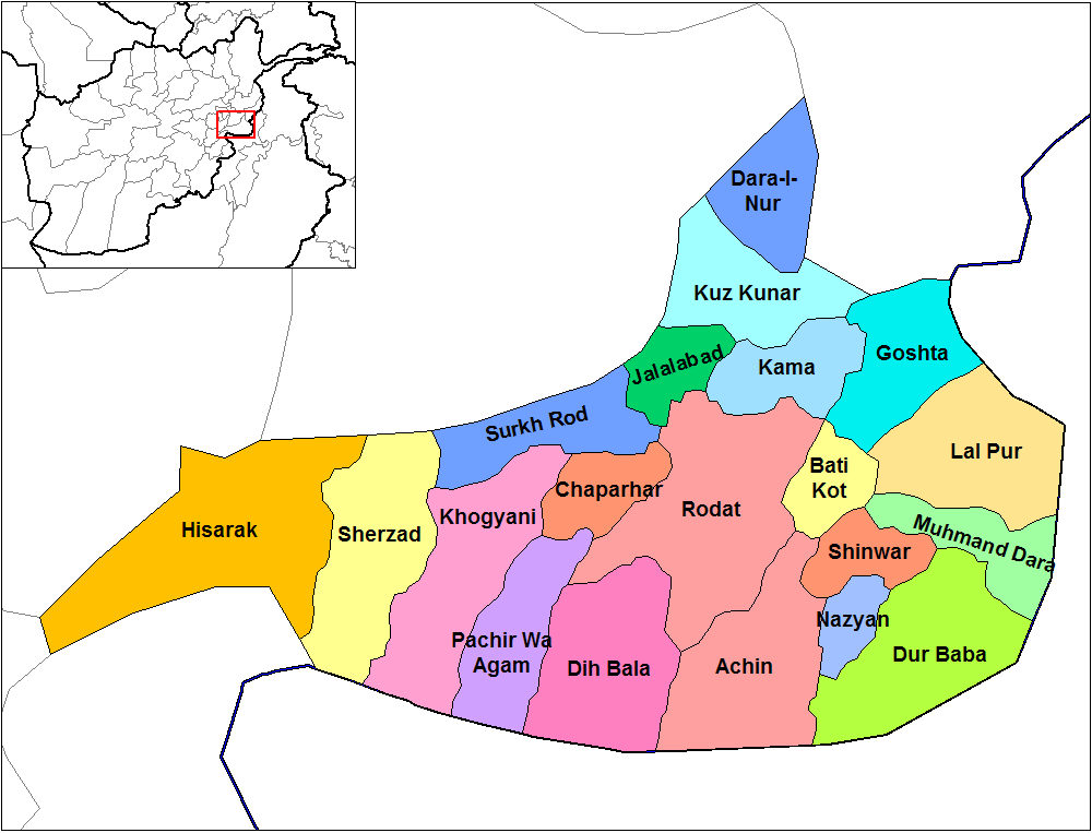
English: Map of the districts of Nangarhar province of Afghanistan. Created by Rarelibra 19:29, 29 March 2007 (UTC) for public domain use, using MapInfo Professional v8.5 and various mapping resources. |
| Datum | 29 maart 2007 (originele uploaddatum) |
| Bron | Geen machineleesbare bron opgegeven. Eigen werk aangenomen (gebaseerd op auteursrechtclaims). |
| Auteur | Geen machineleesbare auteur aanwezig. Op basis van auteursrechtclaims wordt auteur Rarelibra aangenomen. |
Licentie
| Ik, de auteursrechthebbende van dit werk, geef dit werk vrij in het publieke domein. Dit is wereldwijd van toepassing. In sommige landen is dit wettelijk niet mogelijk; in die gevallen geldt: Ik sta iedereen toe dit werk voor eender welk doel te gebruiken, zonder enige voorwaarden, tenzij zulke voorwaarden door de wet worden voorgeschreven. |
Bestandsgeschiedenis
Klik op een datum/tijd om het bestand te zien zoals het destijds was.
| Datum/tijd | Miniatuur | Afmetingen | Gebruiker | Opmerking | |
|---|---|---|---|---|---|
| huidige versie | 15 feb 2024 16:32 | | 1.000 × 763 (43 kB) | User-duck | Cropped 5 % horizontally, 6 % vertically using CropTool with lossless mode. |
| 15 feb 2024 16:31 |  | 1.056 × 816 (43 kB) | User-duck | Reverted to version as of 19:29, 29 March 2007 (UTC)recrop | |
| 14 feb 2024 21:11 |  | 1.000 × 760 (43 kB) | User-duck | Cropped 5 % horizontally, 7 % vertically using CropTool with lossless mode. | |
| 29 mrt 2007 21:29 |  | 1.056 × 816 (43 kB) | Rarelibra | Map of the districts of Nangarhar province of Afghanistan. Created by ~~~~ for public domain use, using MapInfo Professional v8.5 and various mapping resources. |
Bestandsgebruik
Dit bestand wordt op de volgende 3 pagina's gebruikt:
Globaal bestandsgebruik
De volgende andere wiki's gebruiken dit bestand:
- Gebruikt op ar.wikipedia.org
- Gebruikt op bn.wikipedia.org
- Gebruikt op ca.wikipedia.org
- Gebruikt op cs.wikipedia.org
- Gebruikt op de.wikipedia.org
- Gebruikt op en.wikipedia.org
- Nangarhar Province
- Districts of Afghanistan
- Haji Ghalib
- Achin District
- Bati Kot District
- Chaparhar District
- Darai Nur District
- Dur Baba District
- Goshta District
- Hesarak District
- Kama District
- Khogyani District
- Kuz Kunar District
- Lal Pur District
- Momand Dara District
- Nazyan District
- Pachir Aw Agam District
- Rodat District
- Sherzad District
- User talk:Rarelibra/Maps1
- Haska Meyna District
- Khogyani (Pashtun tribe)
- Kot District
- Haska Meyna
- Battle of Tora Bora (2017)
Globaal gebruik van dit bestand bekijken.