
Bestand:National-atlas-louisiana.png
Geen hogere resolutie beschikbaar.
National-atlas-louisiana.png (778 × 584 pixels, bestandsgrootte: 117 kB, MIME-type: image/png)
| Dit is een bestand van Wikimedia Commons. Onderstaande beschrijving komt van de beschrijving van het bestand daar. |
Beschrijving
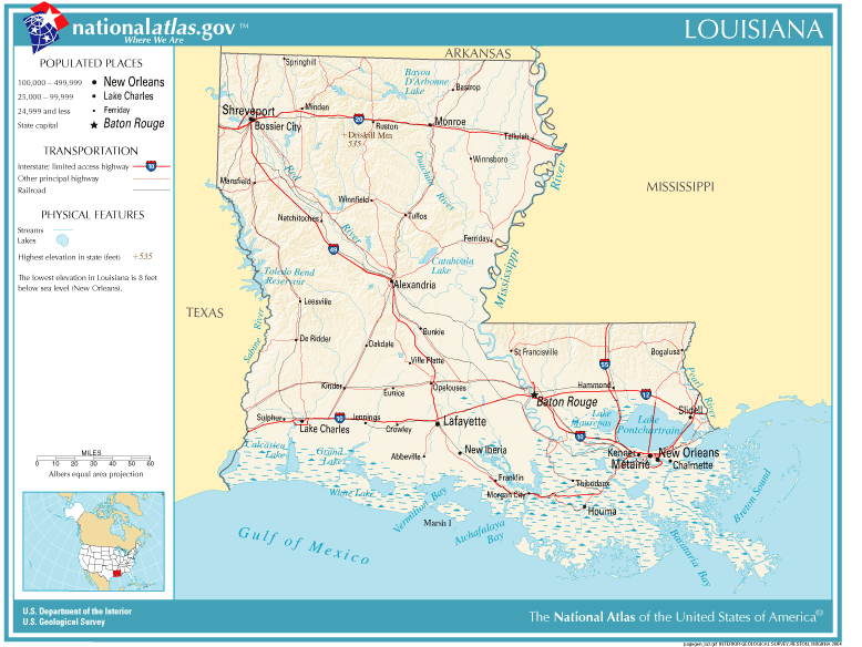
| Beschrijving | Louisiana map |
| Bron | Originally from Image%3ANational-atlas-louisiana.PNG. |
| Auteur |
Licentie
This map was obtained from an edition of the National Atlas of the United States. Like almost all works of the U.S. federal government, works from the National Atlas are in the public domain in the United States.
Online access: NationalAtlas.gov | 1970 print edition: Library of Congress, Perry-Castañeda Library
|
Wikipedia upload log
(All user names refer to en.wikipedia)
- 2004-11-05 01:28 Queson 778×584×8 (120201 bytes) National Atlas map of Louisiana {{PD-USGov}}
Bestandsgeschiedenis
Klik op een datum/tijd om het bestand te zien zoals het destijds was.
| Datum/tijd | Miniatuur | Afmetingen | Gebruiker | Opmerking | |
|---|---|---|---|---|---|
| huidige versie | 9 mei 2007 14:05 | | 778 × 584 (117 kB) | Hbk33 | {{Information |Description=en:Category:Louisiana maps |Source=Originally from [http://en.wikipedia.org en.wikipedia]; description page is/was [http://en.wikipedia.org/w/index.php?title=Image%3ANational-atlas-louisiana.PNG here]. |Date=2004-11-05 (ori |
Bestandsgebruik
Dit bestand wordt op de volgende pagina gebruikt:
Globaal bestandsgebruik
De volgende andere wiki's gebruiken dit bestand:
- Gebruikt op ar.wikipedia.org
- Gebruikt op en.wikivoyage.org
- Gebruikt op eu.wikipedia.org
- Gebruikt op fr.wikipedia.org
- Gebruikt op gu.wikipedia.org
- Gebruikt op he.wikipedia.org
- Gebruikt op hr.wiktionary.org
- Gebruikt op ja.wikipedia.org
- Gebruikt op kn.wikipedia.org
- Gebruikt op pam.wikipedia.org
- Gebruikt op pl.wikivoyage.org
- Gebruikt op ro.wikipedia.org
- Gebruikt op sw.wikipedia.org
- Gebruikt op tr.wikipedia.org
- Gebruikt op zh-yue.wikipedia.org