
Bestand:Saudi Arabian–Iraqi Neutral Zone 1990.jpg

Geen hogere resolutie beschikbaar.
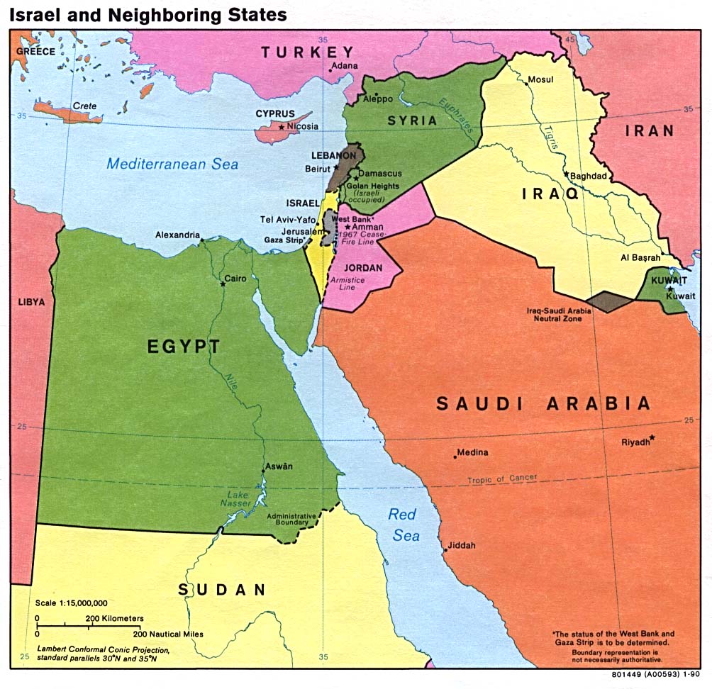
Saudi_Arabian–Iraqi_Neutral_Zone_1990.jpg (404 × 444 pixels, bestandsgrootte: 70 kB, MIME-type: image/jpeg)
| Dit is een bestand van Wikimedia Commons. Onderstaande beschrijving komt van de beschrijving van het bestand daar. |
A map showing, Iran, Iraq, Syria, Jordan, Saudi Arabia, Turkey, Kuwait, and the former Iraq - Saudi Arabia Neutral Zone. Map is from http://www.lib.utexas.edu/maps/middle_east_and_asia/israel_nbr90.jpg.
| This image is a work of a Central Intelligence Agency employee, taken or made as part of that person's official duties. As a Work of the United States Government, this image or media is in the public domain in the United States.
|

|
.jpg)
Bestandsgeschiedenis
Klik op een datum/tijd om het bestand te zien zoals het destijds was.
| Datum/tijd | Miniatuur | Afmetingen | Gebruiker | Opmerking | |
|---|---|---|---|---|---|
| huidige versie | 29 jan 2007 09:29 | | 404 × 444 (70 kB) | Hoshie | A map showing, Iran, Iraq, Syria, Jordan, Saudi Arabia, Turkey, Kuwait, and the former Iraq - Saudi Arabia Neutral Zone. Map is from [http://www.lib.utexas.edu/maps/middle_east_and_asia/israel_nbr90.jpg http://www.lib.utexas.edu/maps/middle_east_and_asia/ |
Bestandsgebruik
Dit bestand wordt op de volgende 2 pagina's gebruikt:
Globaal bestandsgebruik
De volgende andere wiki's gebruiken dit bestand:
- Gebruikt op ar.wikipedia.org
- Gebruikt op ca.wikipedia.org
- Gebruikt op cs.wikipedia.org
- Gebruikt op de.wikipedia.org
- Gebruikt op el.wikipedia.org
- Gebruikt op en.wikipedia.org
- Gebruikt op eo.wikipedia.org
- Gebruikt op es.wikipedia.org
- Gebruikt op fa.wikipedia.org
- Gebruikt op fi.wikipedia.org
- Gebruikt op fr.wikipedia.org
- Gebruikt op hr.wikipedia.org
- Gebruikt op it.wikipedia.org
- Gebruikt op ja.wikipedia.org
- Gebruikt op ko.wikipedia.org
- Gebruikt op lt.wikipedia.org
- Gebruikt op no.wikipedia.org
- Gebruikt op pl.wikipedia.org
- Gebruikt op pt.wikipedia.org
- Gebruikt op ru.wikipedia.org
- Gebruikt op uk.wikipedia.org
- Gebruikt op ur.wikipedia.org
- Gebruikt op www.wikidata.org
- Gebruikt op zh.wikipedia.org