
Bestand:Pacific Northwest River System.png

Grootte van deze voorvertoning: 569 × 599 pixels. Andere resoluties: 228 × 240 pixels | 456 × 480 pixels | 729 × 768 pixels | 973 × 1.024 pixels | 1.930 × 2.032 pixels.
Oorspronkelijk bestand (1.930 × 2.032 pixels, bestandsgrootte: 412 kB, MIME-type: image/png)
| Dit is een bestand van Wikimedia Commons. Onderstaande beschrijving komt van de beschrijving van het bestand daar. |
Beschrijving
| Beschrijving |
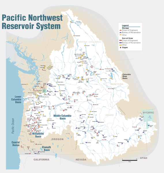
English: Maps of dams, drainage and estuaries along the Columbia River in North America (USA, Canada). Original caption: The Columbia River carved the Interior Columbia River Basin from the landscape of seven Western states and two Canadian provinces. The river itself flows from its headwaters in British Columbia, Canada through only two states, forming part of the Washington-Oregon border, the vast Interior Columbia River Basin is defined by the area drained by the river and its many tributaries. This 58-million-hectare area (about the size of France) extends roughly from the crest of the Cascade Mountains of Oregon and Washington east through Idaho to the Continental Divide in the Rocky Mountains of Montana and Wyoming, and from the headwaters of the Columbia River in Canada to the high desert of northern Nevada and northwestern Utah. |
| Datum | |
| Bron | Portland District Visual Information, U.S. Army Corps of Engineers |
| Auteur | U.S. Army Corps of Engineers |
| Andere versies |
Afgeleide werken van dit bestand: Columbia.png |
Licentie
Deze afbeelding of bestand is een werk van een soldaat of werknemer van het U.S. Army Corps of Engineers, genomen of gemaakt tijdens de uitvoer van diens officiële taken. Als werk van de federale overheid van de Verenigde Staten bevindt de afbeelding zich in het publiek domein.
|
Bestandsgeschiedenis
Klik op een datum/tijd om het bestand te zien zoals het destijds was.
| Datum/tijd | Miniatuur | Afmetingen | Gebruiker | Opmerking | |
|---|---|---|---|---|---|
| huidige versie | 12 jan 2010 00:31 | | 1.930 × 2.032 (412 kB) | Spankston | larger file, higher resolution |
| 11 jan 2010 23:56 |  | 914 × 963 (565 kB) | Spankston | {{Information |Description={{en|1=Maps of dams, drainage and estuaries along the Columbia River in North America (USA, Canada). Original caption: The Columbia River carved the Interior Columbia River Basin from the landscape of seven Western states a |
Bestandsgebruik
Dit bestand wordt op de volgende pagina gebruikt:
Globaal bestandsgebruik
De volgende andere wiki's gebruiken dit bestand:
- Gebruikt op bg.wikipedia.org
- Gebruikt op de.wikipedia.org
- Gebruikt op en.wikipedia.org
- Rocky Reach Dam
- Rock Island Dam
- Wanapum Dam
- Priest Rapids Dam
- Bonneville Dam
- Salmon River (Idaho)
- List of rivers of Washington (state)
- List of dams in the Columbia River watershed
- Revelstoke Dam
- The Dalles Dam
- Keenleyside Dam
- Columbia River Treaty
- Little Goose Dam
- Lower Granite Dam
- Lower Monumental Dam
- Ice Harbor Dam
- Dworshak Dam
- Palisades Dam
- Hells Canyon Dam
- Oxbow Dam
- Brownlee Dam
- Jackson Lake Dam
- C. J. Strike Dam
- Lake Cascade
- Deadwood Reservoir
- Lucky Peak Dam
- Arrowrock Dam
- Anderson Ranch Dam
- Zosel Dam
- User:Mdmunabbir/sandbox
- Gebruikt op fi.wikipedia.org
- Gebruikt op fr.wikipedia.org
- Gebruikt op fy.wikipedia.org
- Gebruikt op he.wikipedia.org
- Gebruikt op it.wikipedia.org
- Gebruikt op no.wikipedia.org
Globaal gebruik van dit bestand bekijken.