
Bestand:Rethymnon municipalities numbered.png

Grootte van deze voorvertoning: 709 × 600 pixels. Andere resoluties: 284 × 240 pixels | 567 × 480 pixels.
Oorspronkelijk bestand (800 × 677 pixels, bestandsgrootte: 61 kB, MIME-type: image/png)
| Dit is een bestand van Wikimedia Commons. Onderstaande beschrijving komt van de beschrijving van het bestand daar. |
Beschrijving
| Beschrijving |
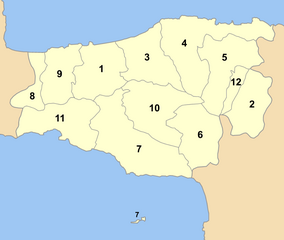
Map of Rethyymnon prefecture (Greece) with administrative divisions (municipalities) numbered in alphabetical order (in greek). Legend:
|
| Datum | |
| Bron | Eigen werk |
| Auteur | Pitichinaccio |
Licentie
| Ik, de auteursrechthebbende van dit werk, geef dit werk vrij in het publieke domein. Dit is wereldwijd van toepassing. In sommige landen is dit wettelijk niet mogelijk; in die gevallen geldt: Ik sta iedereen toe dit werk voor eender welk doel te gebruiken, zonder enige voorwaarden, tenzij zulke voorwaarden door de wet worden voorgeschreven. |
Bestandsgeschiedenis
Klik op een datum/tijd om het bestand te zien zoals het destijds was.
| Datum/tijd | Miniatuur | Afmetingen | Gebruiker | Opmerking | |
|---|---|---|---|---|---|
| huidige versie | 2 sep 2007 20:35 | | 800 × 677 (61 kB) | Pitichinaccio | new version with Zoniana community |
| 11 jul 2007 13:33 |  | 1.000 × 631 (64 kB) | Pitichinaccio | {{Information |Description=Map of Rethyymnon prefecture (Greece) with administrative divisions (municipalities) numbered in alphabetical order (in greek). Legend: *1 -- Δήμος Ρεθύμνου -- Rethymno *2 -- Δήμος Ανωγείων -- Anogia * |
Bestandsgebruik
Dit bestand wordt op de volgende pagina gebruikt:
Globaal bestandsgebruik
De volgende andere wiki's gebruiken dit bestand:
- Gebruikt op de.wikipedia.org
- Gebruikt op el.wikipedia.org
- Gebruikt op fi.wikipedia.org
- Gebruikt op fr.wikipedia.org
- Gebruikt op hr.wikipedia.org
- Gebruikt op it.wikipedia.org
- Gebruikt op ja.wikipedia.org
- Gebruikt op ko.wikipedia.org
- Gebruikt op la.wikipedia.org
- Gebruikt op ru.wikipedia.org
- Gebruikt op sh.wikipedia.org