
Bestand:ScotlandEastRenfrewshire.png
Geen hogere resolutie beschikbaar.
ScotlandEastRenfrewshire.png (200 × 230 pixels, bestandsgrootte: 4 kB, MIME-type: image/png)
| Dit is een bestand van Wikimedia Commons. Onderstaande beschrijving komt van de beschrijving van het bestand daar. |
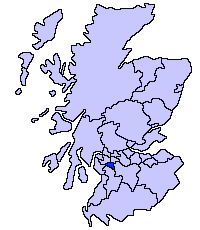
East Renfrewshire unitary council
Slightly edited version of a map drawn by Morwen

|
Toestemming wordt verleend voor het kopiëren, verspreiden en/of wijzigen van dit document onder de voorwaarden van de GNU-licentie voor vrije documentatie, versie 1.2 of enige latere versie als gepubliceerd door de Free Software Foundation; zonder Invariant Sections, zonder Front-Cover Texts, en zonder Back-Cover Texts. Een kopie van de licentie is opgenomen in de sectie GNU-licentie voor vrije documentatie. |
| Dit bestand is gelicenseerd onder de Creative Commons-licentie Naamsvermelding-Gelijk delen 3.0 Unported | ||
| ||
| Deze licentietag is toegevoegd aan dit bestand in verband met de GFDL licentie-update. |
Bestandsgeschiedenis
Klik op een datum/tijd om het bestand te zien zoals het destijds was.
| Datum/tijd | Miniatuur | Afmetingen | Gebruiker | Opmerking | |
|---|---|---|---|---|---|
| huidige versie | 17 mei 2005 23:34 | | 200 × 230 (4 kB) | Voyager | East Renfrewshire unitary council Slightly edited version of a map drawn by Morwen {{GFDL}} Category:Maps of Scottish unitary councils |
Bestandsgebruik
Geen enkele pagina gebruikt dit bestand.
Globaal bestandsgebruik
De volgende andere wiki's gebruiken dit bestand:
- Gebruikt op be.wikipedia.org
- Gebruikt op bg.wikipedia.org
- Gebruikt op ca.wikipedia.org
- Gebruikt op cy.wikipedia.org
- Gebruikt op da.wikipedia.org
- Gebruikt op de.wikipedia.org
- Gebruikt op en.wikipedia.org
- Gebruikt op et.wikipedia.org
- Gebruikt op eu.wikipedia.org
- Ekialdeko Renfrewshire
- Lankide:Euskaldunaa
- Giffnock
- Newton Mearns
- Caldwell dorrea
- Txantiloi:Ekialdeko Renfrewshire
- Wikiproiektu:Irlanda, Gales eta Eskoziako udalerriak
- Barrhead
- Clarkston (Ekialdeko Renfrewshire)
- Busby (Ekialdeko Renfrewshire)
- Eaglesham
- Neilston
- Uplawmoor
- Waterfoot (Ekialdeko Renfrewshire)
- Shillford
- Arthurlie
- Muirend
- Netherlee
- Stamperland
- Thornliebank
- Gebruikt op ga.wikipedia.org
- Gebruikt op gv.wikipedia.org
- Gebruikt op nn.wikipedia.org
- Gebruikt op no.wikipedia.org
- Gebruikt op pt.wikipedia.org
- Gebruikt op sv.wikipedia.org
- Gebruikt op uk.wikipedia.org
- Gebruikt op www.wikidata.org
- Gebruikt op zh-min-nan.wikipedia.org
- Gebruikt op zh.wikipedia.org