
Bestand:Terremoto de Chile de 2010.svg

Afmetingen van deze voorvertoning van het type PNG van dit SVG-bestand: 600 × 583 pixels Andere resoluties: 247 × 240 pixels | 494 × 480 pixels | 790 × 768 pixels | 1.054 × 1.024 pixels | 2.108 × 2.048 pixels.
Oorspronkelijk bestand (SVG-bestand, nominaal 600 × 583 pixels, bestandsgrootte: 181 kB)
| Dit is een bestand van Wikimedia Commons. Onderstaande beschrijving komt van de beschrijving van het bestand daar. |
Beschrijving
| Beschrijving |
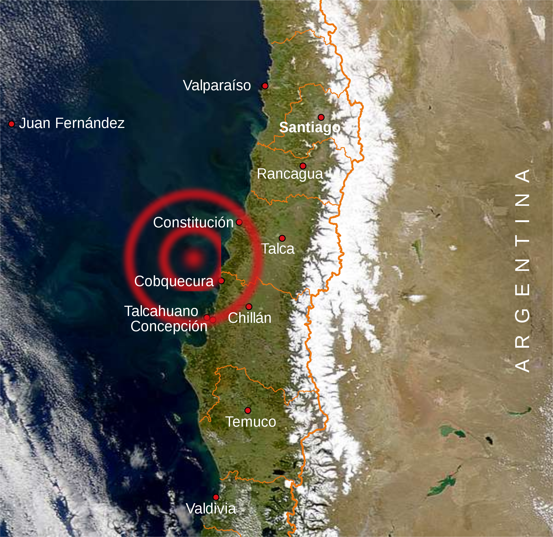
English: Map of the main towns affected by the 2010 Chile earthquake
Español: Mapa con las principales ciudades afectadas por el terremoto de 2010 en Chile. |
| Datum | |
| Bron | Eigen werk, Central Chile.jpg, Mapa de Chile.svg |
| Auteur | B1mbo |
Licentie
Ik, de auteursrechthebbende van dit werk, maak het hierbij onder de volgende licenties beschikbaar:

|
Toestemming wordt verleend voor het kopiëren, verspreiden en/of wijzigen van dit document onder de voorwaarden van de GNU-licentie voor vrije documentatie, versie 1.2 of enige latere versie als gepubliceerd door de Free Software Foundation; zonder Invariant Sections, zonder Front-Cover Texts, en zonder Back-Cover Texts. Een kopie van de licentie is opgenomen in de sectie GNU-licentie voor vrije documentatie. |
This file is licensed under the Creative Commons Attribution-Share Alike 4.0 International, 3.0 Unported, 2.5 Generic, 2.0 Generic and 1.0 Generic license.
- De gebruiker mag:
- Delen – het werk kopiëren, verspreiden en doorgeven
- Remixen – afgeleide werken maken
- Onder de volgende voorwaarden:
- naamsvermelding – U moet op een gepaste manier aan naamsvermelding doen, een link naar de licentie geven, en aangeven of er wijzigingen in het werk zijn aangebracht. U mag dit op elke redelijke manier doen, maar niet zodanig dat de indruk wordt gewekt dat de licentiegever instemt met uw werk of uw gebruik van zijn werk.
- Gelijk delen – Als u het werk heeft geremixt, veranderd, of erop heeft voortgebouwd, moet u het gewijzigde materiaal verspreiden onder dezelfde licentie als het oorspronkelijke werk, of een daarmee compatibele licentie.
U mag zelf één van de licenties kiezen.
Bestandsgeschiedenis
Klik op een datum/tijd om het bestand te zien zoals het destijds was.
| Datum/tijd | Miniatuur | Afmetingen | Gebruiker | Opmerking | |
|---|---|---|---|---|---|
| huidige versie | 1 mrt 2010 22:04 | | 600 × 583 (181 kB) | B1mbo | m |
| 1 mrt 2010 22:00 |  | 600 × 583 (179 kB) | B1mbo | m | |
| 1 mrt 2010 21:51 |  | 600 × 583 (106 kB) | B1mbo | incrusted image | |
| 1 mrt 2010 21:47 |  | 600 × 583 (104 kB) | B1mbo | {{Information |Description={{en|1=Map of the main towns affected by the 2010 Chile earthquake}} {{es|1=Mapa con las principales ciudades afectadas por el terremoto de 2010 en Chile.}} |Sourc |
Bestandsgebruik
Dit bestand wordt op de volgende pagina gebruikt:
Globaal bestandsgebruik
De volgende andere wiki's gebruiken dit bestand:
- Gebruikt op en.wikinews.org
- Gebruikt op es.wikipedia.org
- Gebruikt op fr.wikinews.org
- Gebruikt op id.wikipedia.org
- Gebruikt op pl.wikipedia.org
- Gebruikt op pt.wikipedia.org
- Gebruikt op qu.wikipedia.org