
Bestand:The Man in the High Castle Plausible World Map.png
Grootte van deze voorvertoning: 800 × 579 pixels. Andere resoluties: 320 × 232 pixels | 640 × 463 pixels | 1.024 × 741 pixels | 1.280 × 926 pixels | 1.577 × 1.141 pixels.
Oorspronkelijk bestand (1.577 × 1.141 pixels, bestandsgrootte: 400 kB, MIME-type: image/png)
| Dit is een bestand van Wikimedia Commons. Onderstaande beschrijving komt van de beschrijving van het bestand daar. |

|
This map, as well as other fictitious maps, is fictitious or too incorrect (i.e. due to anachronism) to be used in real-life contexts (contemporary or historic). It may have some visual elements that are similar to official maps such as colors or certain layout features, but they are NOT official and don't have any official recognition. |
[[Category:]]
Beschrijving
| Beschrijving |
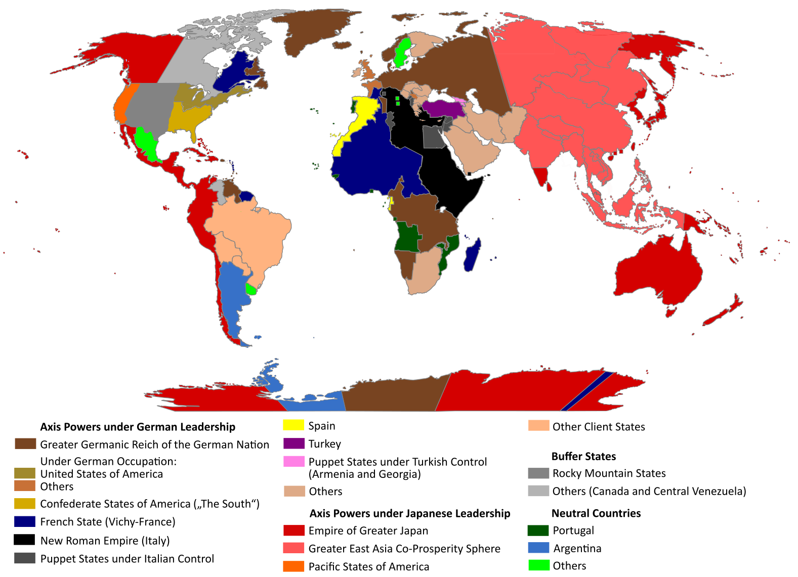
English: "The Man in the High Castle" is an alternate history novel by Philip K. Dick. It is set in a world in which the Axis powers have won World War II. This map is inspired by Dick's story and shows a plausible division of the world between Nazi Germany (dark brown), Imperial Japan (dark red) and their respective allies. However, the map is much more precise than the book describes.
https://web.archive.org/web/20191202005150/http://www.high-castle-world-map.com:80/ |
| Datum | |
| Bron | Eigen werk |
| Auteur | RobintheHighCastle |
| Toestemming (Hergebruik van dit bestand) |
Licentie
Ik, de auteursrechthebbende van dit werk, maak het hierbij onder de volgende licentie beschikbaar:
Dit bestand is gelicenseerd onder de Creative Commons Naamsvermelding-GelijkDelen 4.0 Internationaal licentie.
- De gebruiker mag:
- Delen – het werk kopiëren, verspreiden en doorgeven
- Remixen – afgeleide werken maken
- Onder de volgende voorwaarden:
- naamsvermelding – U moet op een gepaste manier aan naamsvermelding doen, een link naar de licentie geven, en aangeven of er wijzigingen in het werk zijn aangebracht. U mag dit op elke redelijke manier doen, maar niet zodanig dat de indruk wordt gewekt dat de licentiegever instemt met uw werk of uw gebruik van zijn werk.
- Gelijk delen – Als u het werk heeft geremixt, veranderd, of erop heeft voortgebouwd, moet u het gewijzigde materiaal verspreiden onder dezelfde licentie als het oorspronkelijke werk, of een daarmee compatibele licentie.
Bestandsgeschiedenis
Klik op een datum/tijd om het bestand te zien zoals het destijds was.
| Datum/tijd | Miniatuur | Afmetingen | Gebruiker | Opmerking | |
|---|---|---|---|---|---|
| huidige versie | 29 okt 2021 16:55 | | 1.577 × 1.141 (400 kB) | Saltner67 | Added the portoguese colonies Cabinda and Ajuda since they would still have existed in this world. |
| 20 jun 2021 10:05 |  | 1.613 × 1.143 (417 kB) | Gernsback67 | Changed "Greater Asian Co-Prosperity Sphere" in "Greater East Asia Co-Prosperity Sphere", which is correct. | |
| 16 okt 2020 17:30 |  | 1.611 × 1.138 (418 kB) | Saltner67 | Restored the latest version. Please do not revert any changes, which have been made to this file so far, without any communication with the author of the map. All changes made here have been initialized by the author and are a result of the same process which has led to the creation of the map in the first place. | |
| 16 okt 2020 10:25 |  | 1.621 × 1.137 (392 kB) | Gooduserdude | RV Original research: this image is based on a source and should not be altered | |
| 29 mrt 2020 16:15 |  | 1.611 × 1.138 (418 kB) | Saltner67 | Improved the accuracy of borders of Mongolia and Manchukuo. | |
| 27 mrt 2020 17:58 |  | 1.607 × 1.138 (418 kB) | Saltner67 | Enlarged Manchukuo and added the puppet states of Yakutia and Krasnoyarsk/Irkutsk after more research on Kantokuen. | |
| 12 mrt 2020 21:07 |  | 1.612 × 1.143 (411 kB) | Saltner67 | Moved the Swiss Canton of Valais from Germany to Italy, as has been prepared in the plans for Operation Tannenbaum. | |
| 8 feb 2020 20:57 |  | 1.605 × 1.139 (411 kB) | Saltner67 | Reinserted the territories of Tunisia,Greece, Crete and Cyprus after research on the Italian plannings and Greece in WWII. | |
| 21 nov 2019 15:21 |  | 1.611 × 1.133 (409 kB) | Gernsback67 | Enlarged Mongolia again after more research on pan-mongolism. | |
| 21 sep 2019 17:13 |  | 1.610 × 1.137 (408 kB) | Saltner67 | unified Mongolia, enlarged Manchukuo and Thailand, re-inserted the real-life borders of Laos and Vietnam after research on Demchugdongrub, Kantokuen, Thailand and Indochina in WWII |
Bestandsgebruik
Dit bestand wordt op de volgende pagina gebruikt:
Globaal bestandsgebruik
De volgende andere wiki's gebruiken dit bestand:
- Gebruikt op ar.wikipedia.org
- Gebruikt op cs.wikipedia.org
- Gebruikt op da.wikipedia.org
- Gebruikt op de.wikipedia.org
- Gebruikt op en.wikipedia.org
- Gebruikt op en.wikiquote.org
- Gebruikt op es.wikipedia.org
- Gebruikt op gl.wikipedia.org
- Gebruikt op he.wikipedia.org
- Gebruikt op hu.wikipedia.org
- Gebruikt op it.wikipedia.org
- Gebruikt op ja.wikipedia.org
- Gebruikt op ko.wikipedia.org
- Gebruikt op lt.wikipedia.org
- Gebruikt op pl.wikipedia.org
- Gebruikt op pt.wikipedia.org
- Gebruikt op ro.wikipedia.org
- Gebruikt op ru.wikipedia.org
- Gebruikt op th.wikipedia.org
- Gebruikt op uk.wikipedia.org
- Gebruikt op zh-classical.wikipedia.org
- Gebruikt op zh.wikipedia.org