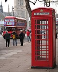
Bestand:The Palace of Westminster, a Routemaster bus, and a red phone box, London, 8 December 2005.jpg

Pagina-inhoud wordt niet ondersteund in andere talen.
Uit Wikipedia, de vrije encyclopedie

Oorspronkelijk bestand(2.215 × 2.771 pixels, bestandsgrootte: 2,08 MB, MIME-type: image/jpeg)


Beschrijving
English: A view of the Palace of Westminster in London, with a classic Routemaster bus on route 159 in the middle ground, and a classic red telephone box in the foreground. The photographer is standing on the west side of Parliament Street, next to the HM Revenue building, looking south east, across the junction with (Westminster) Bridge Street, into St Margarets Street and Abingdon Street. (Bus stop C, Westminster, Parliament Square, and the subway sign for Westminster tube station are partly obscured by the telephone box). The Palace view is of the west facade, with the roof of the Westminster Hall and Victoria Tower in view. The bus is operating route 159 headed north to Trafalgar Square, having presumably just come across Westminster Bridge into Bridge Street and turned right into Parliament Street. The 159 was the last non-heritage bus route to operate with the iconic Routemaster bus, and they were withdrawn from the route the day after this photo was taken, which may or may not explain the presence of the other photographers. The bus is wearing advertising for the heritage Routemaster routes which began operating a month beforehand, in November 2005. There is also another 159 in the background heading south, with route blinds set for Marble Arch (which is to the north). A possible explanation for this paradox is that this bus is operating a short working of the route, possibly to cater for the extra demand due to its imminent conversion, and it is going to use Parliament Square to turn around and head north, with the conductor having already changed the route blinds in anticipation (due to the one way system, southbound 159 buses headed for Streatham also go straight on and around the square, instead of simply turning left into Bridge street).
Datum
Bron originally posted to Flickr as We lost an icon on 8th December 2005
Auteur Jon Bennett
Andere versies
Cameralocatie51° 30′ 05,35″ NB, 0° 07′ 35,46″ WL  Heading=157.5° Kartographer map based on OpenStreetMap.Deze en andere afbeeldingen in: OpenStreetMapinfo


This image, which was originally posted to Flickr, was uploaded to Commons using Flickr upload bot on 12 augustus 2008, 10:30 by Ultra7. On that date, it was confirmed to be licensed under the terms of the license indicated.
w:nl:Creative Commons
naamsvermelding
Dit bestand is gelicenseerd onder de Creative Commons-licentie Naamsvermelding 2.0 Unported
De gebruiker mag:
  • Delen – het werk kopiëren, verspreiden en doorgeven
  • Remixen – afgeleide werken maken
Onder de volgende voorwaarden:
  • naamsvermelding – U moet op een gepaste manier aan naamsvermelding doen, een link naar de licentie geven, en aangeven of er wijzigingen in het werk zijn aangebracht. U mag dit op elke redelijke manier doen, maar niet zodanig dat de indruk wordt gewekt dat de licentiegever instemt met uw werk of uw gebruik van zijn werk.

Bijschriften

Beschrijf in één regel wat dit bestand voorstelt

Items getoond in dit bestand

beeldt af

51°30'5.350"N, 0°7'35.461"W

kijkrichting: 157,5 booggraad

Bestandsgeschiedenis

Klik op een datum/tijd om het bestand te zien zoals het destijds was.

Datum/tijdMiniatuurAfmetingenGebruikerOpmerking
huidige versie15 dec 2011 20:28Miniatuurafbeelding voor de versie van 15 dec 2011 20:282.215 × 2.771 (2,08 MB)RotatebotBot: Reset EXIF-specified Orientation of image (EXIF-Orientation set from 16 to 0, rotated 0°)
12 aug 2008 12:37Miniatuurafbeelding voor de versie van 12 aug 2008 12:372.771 × 2.215 (2,08 MB)Flickr upload botUploaded from http://flickr.com/photo/35765599@N00/71574767 using Flickr upload bot

Dit bestand wordt op de volgende pagina gebruikt:

Metadata