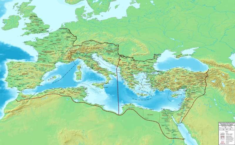
Bestand:The Roman Empire ca 400 AD.png

Grootte van deze voorvertoning: 800 × 496 pixels. Andere resoluties: 320 × 198 pixels | 640 × 397 pixels | 1.024 × 635 pixels | 1.280 × 793 pixels | 2.560 × 1.587 pixels | 4.339 × 2.689 pixels.
Oorspronkelijk bestand (4.339 × 2.689 pixels, bestandsgrootte: 12,8 MB, MIME-type: image/png)
Bestandsgeschiedenis
Klik op een datum/tijd om het bestand te zien zoals het destijds was.
| Datum/tijd | Miniatuur | Afmetingen | Gebruiker | Opmerking | |
|---|---|---|---|---|---|
| huidige versie | 20 feb 2015 00:27 |  | 4.339 × 2.689 (12,8 MB) | Cplakidas | added potential location of Valentia beyond Hadrian's Wall, removed provincial boundaries in Britannia as too tentative |
| 21 jul 2011 15:03 |  | 4.339 × 2.689 (10,9 MB) | Cplakidas | fixed Persian border, differentiated between Eastern and Western empire, different borders for praet. prefectures | |
| 21 mrt 2009 04:37 |  | 4.475 × 2.600 (9,99 MB) | Cplakidas | minor corrections | |
| 29 mei 2008 14:30 |  | 3.800 × 2.370 (8,1 MB) | Cplakidas | ||
| 29 mei 2008 14:17 |  | 4.560 × 2.850 (11,22 MB) | Cplakidas | clearer version & addition of the Armenian satrapies | |
| 30 dec 2007 04:02 |  | 3.380 × 2.120 (5,96 MB) | Cplakidas | added names of dioceses, legend box, various minor adjustments | |
| 13 dec 2007 16:27 |  | 3.550 × 2.200 (6,65 MB) | Cplakidas | new improved version made with Inkscape, slight corrections in borders, added several cities in Africa & Spain | |
| 12 nov 2007 21:27 |  | 3.550 × 2.200 (4,75 MB) | Cplakidas | minor corrections in southern Gaul | |
| 5 nov 2007 14:58 |  | 3.550 × 2.200 (4,75 MB) | Cplakidas | New version, with some corrections & additions | |
| 31 okt 2007 18:55 |  | 3.436 × 2.142 (4,5 MB) | Cplakidas | {{Information |Description=Map of the Roman Empire ca. 400 AD, showing the administrative division into dioceses and provinces, as well as the major cities. The demarcation between Eastern and Western Empires is noted in red. |Source=Base map found at |
Bestandsgebruik
Dit bestand wordt op de volgende pagina gebruikt:
Globaal bestandsgebruik
De volgende andere wiki's gebruiken dit bestand:
- Gebruikt op af.wikipedia.org
- Gebruikt op ar.wikipedia.org
- Gebruikt op ary.wikipedia.org
- Gebruikt op ast.wikipedia.org
- Gebruikt op bg.wikipedia.org
- Gebruikt op bn.wikipedia.org
- Gebruikt op ca.wikipedia.org
- Gebruikt op ceb.wikipedia.org
- Gebruikt op cs.wikipedia.org
- Gebruikt op de.wikipedia.org
- Gebruikt op el.wikipedia.org
- Gebruikt op en.wikipedia.org
- Gebruikt op eo.wikipedia.org
- Gebruikt op es.wikipedia.org
- Gebruikt op et.wikipedia.org
- Gebruikt op fr.wikipedia.org
- Gebruikt op he.wikipedia.org
- Gebruikt op hi.wikipedia.org
- Gebruikt op hr.wikipedia.org
- Gebruikt op hu.wikipedia.org
- Gebruikt op id.wikipedia.org
- Gebruikt op it.wikipedia.org
- Gebruikt op ko.wikipedia.org
- Gebruikt op la.wikipedia.org
- Gebruikt op lt.wikipedia.org
- Gebruikt op no.wikipedia.org
Globaal gebruik van dit bestand bekijken.


