
Bestand:Topography of africa.jpg

Grootte van deze voorvertoning: 548 × 599 pixels. Andere resoluties: 219 × 240 pixels | 439 × 480 pixels | 702 × 768 pixels | 936 × 1.024 pixels | 1.463 × 1.600 pixels.
Oorspronkelijk bestand (1.463 × 1.600 pixels, bestandsgrootte: 475 kB, MIME-type: image/jpeg)
| Dit is een bestand van Wikimedia Commons. Onderstaande beschrijving komt van de beschrijving van het bestand daar. |
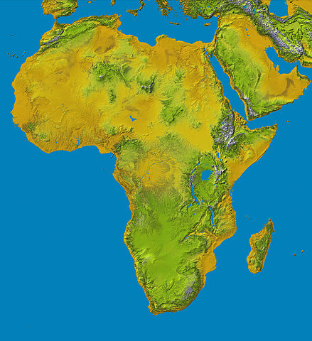
Topography of Africa
image description here:
- PIA04965: SRTM Data Release for Africa, Colored Height
- Elevation data at the highest possible resolution from NASA's SRTM mission in February 2000 are being released for the first time for most of the African continent. This color shaded relief image shows the extent of SRTM digital elevation data for Africa.
- This color shaded relief image shows the extent of digital elevation data for Africa recently released by the Shuttle Radar Topography Mission (SRTM). This release includes data for all of the continent, plus the island of Madagascar and the Arabian Peninsula. SRTM flew on board the Space Shuttle Endeavour in February 2000 and used an interferometric radar system to map the topography of Earth's landmass between latitudes 56 degrees south and 60 degrees north.
larger version here Image credit: NASA/JPL-Caltech
| Dit bestand bevindt zich in het publiek domein, omdat het gemaakt is door de NASA. In de reproductierichtlijnen van de NASA staat dat "NASA-materiaal niet beschermd wordt door auteursrecht, tenzij anders vermeld". | ||
 |
Waarschuwingen:
|
Bestandsgeschiedenis
Klik op een datum/tijd om het bestand te zien zoals het destijds was.
| Datum/tijd | Miniatuur | Afmetingen | Gebruiker | Opmerking | |
|---|---|---|---|---|---|
| huidige versie | 27 jan 2006 15:01 | | 1.463 × 1.600 (475 kB) | Perconte~commonswiki | |
| 25 sep 2005 12:34 |  | 552 × 604 (48 kB) | ChongDae | This image was copied from wikipedia:en. The original description was: Topography of Africa image description [http://photojournal.jpl.nasa.gov/catalog/PIA04965 here] larger version [http://photojournal.jpl.nasa.gov/jpeg/PIA04965.jpg here] Image credi |
Bestandsgebruik
Dit bestand wordt op de volgende 3 pagina's gebruikt:
Globaal bestandsgebruik
De volgende andere wiki's gebruiken dit bestand:
- Gebruikt op ar.wikipedia.org
- Gebruikt op cs.wikipedia.org
- Gebruikt op cy.wikipedia.org
- Gebruikt op de.wikipedia.org
- Gebruikt op eml.wikipedia.org
- Gebruikt op eo.wikipedia.org
- Gebruikt op es.wikipedia.org
- Gebruikt op et.wikipedia.org
- Gebruikt op eu.wikipedia.org
- Gebruikt op fa.wikipedia.org
- Gebruikt op hy.wikipedia.org
- Gebruikt op ie.wikipedia.org
- Gebruikt op incubator.wikimedia.org
- Gebruikt op it.wikipedia.org
- Gebruikt op it.wikibooks.org
- Gebruikt op it.wikiversity.org
- Gebruikt op ja.wikipedia.org
- Gebruikt op kab.wikipedia.org
- Gebruikt op ka.wikipedia.org
- Gebruikt op kn.wikipedia.org
- Gebruikt op ko.wikipedia.org
- Gebruikt op lld.wikipedia.org
- Gebruikt op lmo.wikipedia.org
- Gebruikt op ml.wikipedia.org
- Gebruikt op nrm.wikipedia.org
- Gebruikt op pl.wikipedia.org
- Gebruikt op pms.wikipedia.org
- Gebruikt op qu.wikipedia.org
Globaal gebruik van dit bestand bekijken.