
Bestand:Two 1911-08-12 weather map.jpg
Geen hogere resolutie beschikbaar.
Two_1911-08-12_weather_map.jpg (417 × 305 pixels, bestandsgrootte: 24 kB, MIME-type: image/jpeg)
| Dit is een bestand van Wikimedia Commons. Onderstaande beschrijving komt van de beschrijving van het bestand daar. |
Beschrijving
| Beschrijving | ||||
| Datum | ||||
| Bron | NOAA Central Library Data Imaging Project | |||
| Auteur | NOAA Central Library, Silver Spring, Maryland | |||
| Toestemming (Hergebruik van dit bestand) |
|
Bestandsgeschiedenis
Klik op een datum/tijd om het bestand te zien zoals het destijds was.
| Datum/tijd | Miniatuur | Afmetingen | Gebruiker | Opmerking | |
|---|---|---|---|---|---|
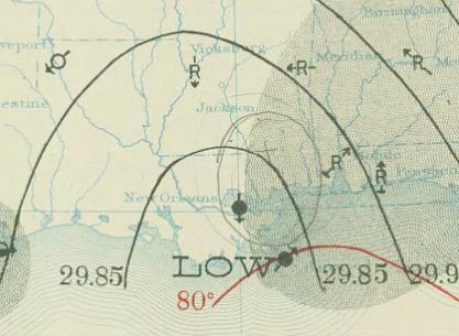
| huidige versie | 29 apr 2010 21:50 | | 417 × 305 (24 kB) | Juliancolton | {{Information |Description={{en|1=August 12, 1911 {{w|surface weather analysis}} of Hurricane Two in the {{w|1910 Atlantic hurricane season}} along the U.S. Gulf Coast. }} |Source=http://docs.lib.noaa.gov/rescue/dwm/1911/19110812.djvu |Author=[http://docs |
Bestandsgebruik
Dit bestand wordt op de volgende pagina gebruikt:
Globaal bestandsgebruik
De volgende andere wiki's gebruiken dit bestand:
- Gebruikt op ca.wikipedia.org
- Gebruikt op en.wikipedia.org
- Gebruikt op pt.wikipedia.org
- Gebruikt op zh.wikipedia.org