
Bestand:UA232map.png

Grootte van deze voorvertoning: 800 × 581 pixels. Andere resoluties: 320 × 232 pixels | 640 × 465 pixels | 1.024 × 744 pixels | 1.280 × 929 pixels | 2.567 × 1.864 pixels.
Oorspronkelijk bestand (2.567 × 1.864 pixels, bestandsgrootte: 60 kB, MIME-type: image/png)
| Dit is een bestand van Wikimedia Commons. Onderstaande beschrijving komt van de beschrijving van het bestand daar. |
Beschrijving
| Beschrijving |
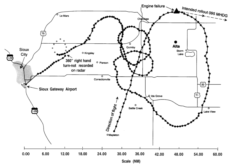
English: A radar map from the NTSB report into United Airlines Flight 232 crash. This shows all the known radar locations of the DC10 involved before its crash landing at Sioux Gateway Airport. |
| Datum | |
| Bron | NTSB accident report |
| Auteur | NTSB |
Licentie
This image is a work of a National Transportation Safety Board employee, taken or made as part of an employee's official duties. As a work of the U.S. federal government, all NTSB images are in the public domain in the United States.
|
Oorspronkelijk uploadlogboek
Verplaatst vanaf en.wikipedia naar Commons door Atmoz met behulp van CommonsHelper.
De oorspronkelijke beschrijving van deze afbeelding stond hier. Alle volgende gebruikersnamen verwijzen naar en.wikipedia.
- 2006-09-06 14:39 John 1005×702× (29356 bytes) Radar map from NTSB report into UA 232 crash
Bestandsgeschiedenis
Klik op een datum/tijd om het bestand te zien zoals het destijds was.
| Datum/tijd | Miniatuur | Afmetingen | Gebruiker | Opmerking | |
|---|---|---|---|---|---|
| huidige versie | 3 sep 2017 02:16 | | 2.567 × 1.864 (60 kB) | Mikhail Ryazanov | original resolution from PDF |
| 5 mei 2010 05:04 |  | 1.005 × 702 (29 kB) | Atmoz | {{Information |Description={{en|Radar map from NTSB report into UA 232 crash}} |Source=Transferred from [http://en.wikipedia.org en.wikipedia]; transferred to Commons by User:Atmoz using [http://tools.wikimedia.de/~magnus/commonshelper.php CommonsHelp |
Bestandsgebruik
Dit bestand wordt op de volgende pagina gebruikt:
Globaal bestandsgebruik
De volgende andere wiki's gebruiken dit bestand:
- Gebruikt op en.wikipedia.org
- Gebruikt op fr.wikipedia.org
- Gebruikt op hu.wikipedia.org
- Gebruikt op it.wikipedia.org
- Gebruikt op ja.wikipedia.org
- Gebruikt op pt.wikipedia.org
- Gebruikt op ru.wikipedia.org