
Bestand:USGS Oregon river basins.png

Grootte van deze voorvertoning: 739 × 600 pixels. Andere resoluties: 296 × 240 pixels | 591 × 480 pixels | 946 × 768 pixels | 1.262 × 1.024 pixels | 1.849 × 1.501 pixels.
Oorspronkelijk bestand (1.849 × 1.501 pixels, bestandsgrootte: 642 kB, MIME-type: image/png)
| Dit is een bestand van Wikimedia Commons. Onderstaande beschrijving komt van de beschrijving van het bestand daar. |
Beschrijving
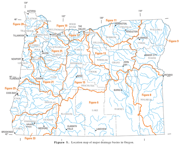
| Beschrijving | River drainage basins in Oregon. |
| Datum | |
| Bron | http://pubs.usgs.gov/wdr/2005/wdr-or-05/pdf/front.pdf (page 51) |
| Auteur | U.S. Geological Survey |
| Toestemming (Hergebruik van dit bestand) |
public domain |
Licentie
Deze afbeelding bevindt zich in het publiek domein omdat het materiaal bevat dat oorspronkelijk afkomstig is van de United States Geological Survey, een agentschap van de United States Department of the Interior. Voor meer informatie, zie het officiële USGS-auteursrechtenbeleid
|
Bestandsgeschiedenis
Klik op een datum/tijd om het bestand te zien zoals het destijds was.
| Datum/tijd | Miniatuur | Afmetingen | Gebruiker | Opmerking | |
|---|---|---|---|---|---|
| huidige versie | 10 feb 2013 21:52 | | 1.849 × 1.501 (642 kB) | Kmusser | Baker City correction |
| 10 nov 2011 19:55 |  | 1.849 × 1.501 (433 kB) | Finetooth | Corrected my correction of the Grants Pass location. It is a bit further south than I had it on the second version. | |
| 10 nov 2011 04:54 |  | 1.849 × 1.501 (433 kB) | Finetooth | Corrected location of Grants Pass, which is on the Rogue River between the Jackson–Josephine county border and the mouth of the Applegate River. | |
| 16 okt 2006 21:32 |  | 1.849 × 1.501 (723 kB) | EncMstr | {{Information |Description=River drainage basins in Oregon |Source= http://pubs.usgs.gov/wdr/2005/wdr-or-05/pdf/front.pdf page 82 |Date=2006-03-31 |Author=w:USGS |Permission=public domain }} category:Maps of Oregon [[category:Maps of rivers of the |
Bestandsgebruik
Dit bestand wordt op de volgende pagina gebruikt:
Globaal bestandsgebruik
De volgende andere wiki's gebruiken dit bestand:
- Gebruikt op bg.wikipedia.org
- Gebruikt op cs.wikipedia.org
- Gebruikt op en.wikipedia.org
- Gebruikt op hu.wikipedia.org
- Gebruikt op it.wikipedia.org
- Gebruikt op ru.wikipedia.org
- Gebruikt op vi.wikipedia.org