
Bestand:Vladimir Governorate Map.jpg

Oorspronkelijk bestand (1.276 × 1.530 pixels, bestandsgrootte: 223 kB, MIME-type: image/jpeg)
| Dit is een bestand van Wikimedia Commons. Onderstaande beschrijving komt van de beschrijving van het bestand daar. |
Beschrijving
| Beschrijving |
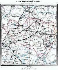
Русский: Карта Владимирской губернии (конец XIX века)
English: Vladimir Governorate map (late XIX century) |
| Datum | 17 december 2007 (originele uploaddatum) |
| Bron |
Brockhaus and Efron Encyclopedic Dictionary |
| Auteur |
. De originele uploader was СафроновАВ op de Russischtalige Wikipedia |
Licentie
This image comes from the Brockhaus and Efron Encyclopedic Dictionary (1890-1907). The copyrights for that book have expired and this image is in the public domain.
|
 |
Dit werk bevindt zich in het publiek domein in Rusland volgens artikel 1256 van het Burgerlijk Wetboek van de Russische Federatie.
Dit werk werd gepubliceerd op het territorium van het Russische Rijk (Russische Republiek) uitgezonderd de gebieden van de Grootvorstendom Finland (Великое княжество Финляндское) en Congres-Polen (Царство Польское) voor 7 november 1917 en werd niet heruitgegeven in de 30 dagen na de eerste publicaties op het grondgebied van Sovjet-Rusland of andere landen. Rusland (voorheen Russische Socialistische Federatieve Sovjetrepubliek) is de historische erfgenaam maar niet de rechtsopvolger van het Russische Rijk.[1][2]
Gebruik indien mogelijk {{PD-Russia-expired}} in plaats van dit sjabloon. Dit werk bevindt zich in het publiek domein in de Verenigde Staten omdat het gepubliceerd werd (of geregistreerd bij de U.S. Copyright Office) voor 1 januari 1929. |
 |
Oorspronkelijk uploadlogboek
- 2007-12-17 08:22 СафроновАВ 1276×1530× (228671 bytes) {{Изображение | Описание = Владимирская губерния | Автор = | Время создания = | Источник = ЭСБЕ }}
Bestandsgeschiedenis
Klik op een datum/tijd om het bestand te zien zoals het destijds was.
| Datum/tijd | Miniatuur | Afmetingen | Gebruiker | Opmerking | |
|---|---|---|---|---|---|
| huidige versie | 26 okt 2009 14:59 | | 1.276 × 1.530 (223 kB) | Transcend (rus) | {{Information |Description={{ru|Карта Владимирской губернии (конец XIX века)}} {{en|Vladimir Governorate map (late XIX century)}} |Source= Brockhaus and Efron Encyclopedic Dictionary</br>Transferred from [http://ru.wikipe |
Bestandsgebruik
Dit bestand wordt op de volgende pagina gebruikt:
Globaal bestandsgebruik
De volgende andere wiki's gebruiken dit bestand:
- Gebruikt op be.wikipedia.org
- Gebruikt op bg.wikipedia.org
- Gebruikt op fi.wikipedia.org
- Gebruikt op it.wikipedia.org
- Gebruikt op ko.wikipedia.org
- Gebruikt op no.wikipedia.org
- Gebruikt op pl.wikipedia.org
- Gebruikt op sv.wikipedia.org
- Gebruikt op tr.wikipedia.org
- Gebruikt op uk.wikipedia.org
- Gebruikt op www.wikidata.org