
Bestand:Wattasid Morocco EN.PNG

Grootte van deze voorvertoning: 514 × 599 pixels. Andere resoluties: 206 × 240 pixels | 636 × 741 pixels.
Oorspronkelijk bestand (636 × 741 pixels, bestandsgrootte: 37 kB, MIME-type: image/png)
| Dit is een bestand van Wikimedia Commons. Onderstaande beschrijving komt van de beschrijving van het bestand daar. |
Beschrijving
| Beschrijving |
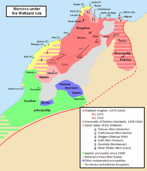
English: Geopolitical map of Morocco under Wattasid rule.
Inspired from a map in the book "Le Maroc dans les premières années du XVIe siècle : Tableau géographique d'après Léon L'Africain", par Louis Massignon, dans "Mémoires de la Société Historique Algérienne I", Éd. Adolphe Jourdan (1906). (Num. OCLC 490558897) (in French). 1472 borders are the ones inherited from the Merinids. |
| Bron | Eigen werk |
| Auteur | Omar-Toons |
| Andere versies | File:Marruecos1500-1515-Col.PNG |
Licentie
Ik, de auteursrechthebbende van dit werk, maak het hierbij onder de volgende licentie beschikbaar:
Dit bestand is gelicenseerd onder de Creative Commons-licentie Naamsvermelding 3.0 Unported
- De gebruiker mag:
- Delen – het werk kopiëren, verspreiden en doorgeven
- Remixen – afgeleide werken maken
- Onder de volgende voorwaarden:
- naamsvermelding – U moet op een gepaste manier aan naamsvermelding doen, een link naar de licentie geven, en aangeven of er wijzigingen in het werk zijn aangebracht. U mag dit op elke redelijke manier doen, maar niet zodanig dat de indruk wordt gewekt dat de licentiegever instemt met uw werk of uw gebruik van zijn werk.
Bestandsgeschiedenis
Klik op een datum/tijd om het bestand te zien zoals het destijds was.
| Datum/tijd | Miniatuur | Afmetingen | Gebruiker | Opmerking | |
|---|---|---|---|---|---|
| huidige versie | 22 mrt 2012 02:23 | | 636 × 741 (37 kB) | Omar-Toons | Hintata allied to Wattasids during the first quarter of the XVIth c. |
| 6 aug 2011 03:36 |  | 636 × 741 (38 kB) | Omar-Toons | minor edit (Esp->Sp) | |
| 6 aug 2011 03:33 |  | 636 × 741 (38 kB) | Omar-Toons | {{Information |Description ={{en|1=Geopolitical map of Morocco under Wattasid rule. Inspired from a map in the book "Le Maroc dans les premières années du XVIe siècle : Tableau géographique d'après Léon L'Africain", par Louis Massignon, dans "M� |
Bestandsgebruik
Geen enkele pagina gebruikt dit bestand.
Globaal bestandsgebruik
De volgende andere wiki's gebruiken dit bestand:
- Gebruikt op ar.wikipedia.org
- Gebruikt op cs.wikipedia.org
- Gebruikt op ru.wikipedia.org