
Bestand:Ww2 europe map italy june until december 1944.jpg

Grootte van deze voorvertoning: 785 × 599 pixels. Andere resoluties: 314 × 240 pixels | 629 × 480 pixels | 1.006 × 768 pixels | 1.265 × 966 pixels.
Oorspronkelijk bestand (1.265 × 966 pixels, bestandsgrootte: 1,89 MB, MIME-type: image/jpeg)
| Dit is een bestand van Wikimedia Commons. Onderstaande beschrijving komt van de beschrijving van het bestand daar. |
Beschrijving
| Beschrijving |
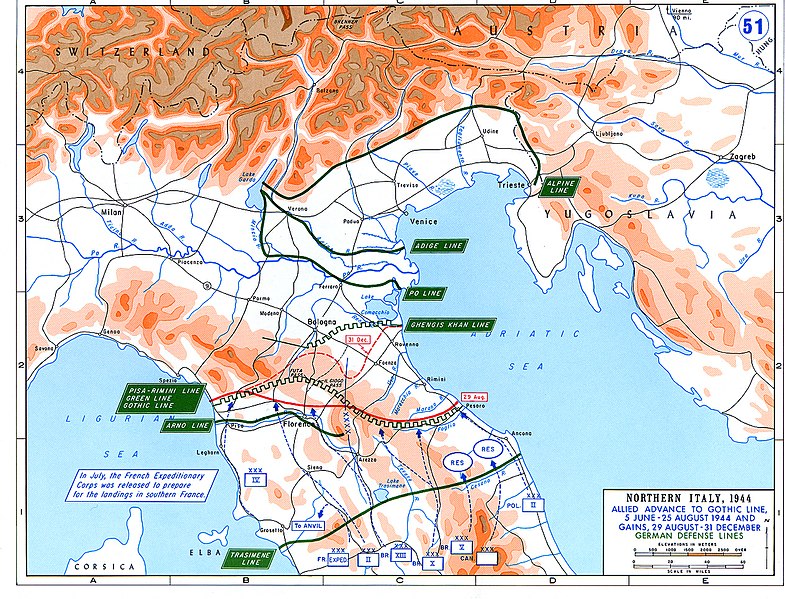
English: Allied Corp formations are depicted in blue. The German defensive lines are shown in green. The solid red line denotes the extent of the Allied advance by 29 August 1944, and the dotted red line is the extent of the Allied advance by 31 December 1944. |
| Datum | |
| Bron | Archive link to original website used for the map and the archive link to the map source page. |
| Auteur | The History Department of the United States Military Academy |
| Toestemming (Hergebruik van dit bestand) |
US Government document |
| Andere versies |
The current version of the map by the The History Department of the United States Military Academy: |

Licentie
Deze afbeelding is een werk van een soldaat of werknemer van de U.S. Army, genomen of gemaakt tijdens de uitvoering van diens officiële taken. Als werk van de federale overheid van de Verenigde Staten bevindt deze afbeelding zich in het publiek domein.
|
 |
Bestandsgeschiedenis
Klik op een datum/tijd om het bestand te zien zoals het destijds was.
| Datum/tijd | Miniatuur | Afmetingen | Gebruiker | Opmerking | |
|---|---|---|---|---|---|
| huidige versie | 20 feb 2021 05:25 | | 1.265 × 966 (1,89 MB) | Buidhe | Reverted to version as of 14:07, 29 February 2020 (UTC) Not a minor change, should be uploaded as new file |
| 20 feb 2021 04:57 |  | 973 × 754 (349 kB) | EnigmaMcmxc | updated version of the map | |
| 29 feb 2020 16:07 |  | 1.265 × 966 (1,89 MB) | Hohum | Fix colour profile | |
| 22 jun 2011 20:21 |  | 1.265 × 966 (1,93 MB) | Hohum | Cleanup | |
| 10 dec 2006 14:26 |  | 1.265 × 966 (2,01 MB) | MatthiasKabel | == License information == {{PD-Layout}} {{PD-USGov}} Original from http://www.dean.usma.edu/history/web03/atlases/ww2%20europe/ww2%20europe%20war%20index.htm |
Bestandsgebruik
Dit bestand wordt op de volgende pagina gebruikt:
Globaal bestandsgebruik
De volgende andere wiki's gebruiken dit bestand:
- Gebruikt op af.wikipedia.org
- Gebruikt op ar.wikipedia.org
- Gebruikt op cs.wikipedia.org
- Gebruikt op de.wikipedia.org
- Gebruikt op en.wikipedia.org
- Gebruikt op es.wikipedia.org
- Gebruikt op fi.wikipedia.org
- Gebruikt op fr.wikipedia.org
- Gebruikt op he.wikipedia.org
- Gebruikt op hu.wikipedia.org
- Gebruikt op id.wikipedia.org
- Gebruikt op it.wikipedia.org
- Gebruikt op ja.wikipedia.org
- Gebruikt op no.wikipedia.org
- Gebruikt op pl.wikipedia.org
- Gebruikt op pt.wikipedia.org
- Gebruikt op ru.wikipedia.org
- Gebruikt op sk.wikipedia.org
- Gebruikt op sl.wikipedia.org
- Gebruikt op sr.wikipedia.org
- Gebruikt op sv.wikipedia.org
- Gebruikt op ta.wikipedia.org
- Gebruikt op uk.wikipedia.org
- Gebruikt op www.wikidata.org
- Gebruikt op zh.wikipedia.org