
Bestand:Zealandia topography.jpg

Grootte van deze voorvertoning: 516 × 600 pixels. Andere resoluties: 206 × 240 pixels | 413 × 480 pixels | 661 × 768 pixels | 881 × 1.024 pixels | 1.391 × 1.617 pixels.
Oorspronkelijk bestand (1.391 × 1.617 pixels, bestandsgrootte: 1,34 MB, MIME-type: image/jpeg)
| Dit is een bestand van Wikimedia Commons. Onderstaande beschrijving komt van de beschrijving van het bestand daar. |
Beschrijving
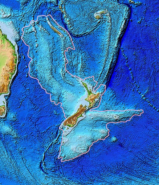
| Beschrijving | Topographical map of the Zealandia continent. |
| Datum | |
| Bron | Ultimate source: ETOPO2v2, a digital database of seafloor and land elevations. Actually cropped from Image:Pacific_elevation.jpg. |
| Auteur | World Data Center for Geophysics & Marine Geology (Boulder, CO), National Geophysical Data Center, NOAA |
| Toestemming (Hergebruik van dit bestand) |
NOAA, public domain |
| Andere versies | Image:Pacific_elevation.jpg, here cropped to focus on Zealandia. |
Licentie
Deze afbeelding is in het publiek domein omdat het materiaal bevat dat oorspronkelijk van de National Oceanic and Atmospheric Administration kwam in de Verenigde Staten en genomen of gemaakt is tijdens de officiële werkzaamheden van een werknemer.
|
Bestandsgeschiedenis
Klik op een datum/tijd om het bestand te zien zoals het destijds was.
| Datum/tijd | Miniatuur | Afmetingen | Gebruiker | Opmerking | |
|---|---|---|---|---|---|
| huidige versie | 28 mrt 2017 15:24 | | 1.391 × 1.617 (1,34 MB) | Bogomolov.PL | continent limits with pink |
| 13 mrt 2007 03:44 |  | 573 × 677 (143 kB) | Avenue | == Summary == {{Information |Description=Topographical map of the Zealandia continent. |Source=Source: [http://www.ngdc.noaa.gov/mgg/image/2minrelief.html]. Actually cropped from Image:Pacific_elevation.jpg. |Date=June 2006 |Permissio |
Bestandsgebruik
Dit bestand wordt op de volgende 2 pagina's gebruikt:
Globaal bestandsgebruik
De volgende andere wiki's gebruiken dit bestand:
- Gebruikt op af.wikipedia.org
- Gebruikt op ang.wikipedia.org
- Gebruikt op ar.wikipedia.org
- Gebruikt op ast.wikipedia.org
- Gebruikt op az.wikipedia.org
- Gebruikt op bg.wikipedia.org
- Gebruikt op bn.wikipedia.org
- Gebruikt op ca.wikipedia.org
- Gebruikt op el.wikipedia.org
- Gebruikt op en.wikipedia.org
- Gebruikt op eo.wikipedia.org
- Gebruikt op es.wikipedia.org
- Gebruikt op et.wikipedia.org
- Gebruikt op eu.wikipedia.org
- Gebruikt op fa.wikipedia.org
- Gebruikt op fi.wikipedia.org
- Gebruikt op fr.wikipedia.org
- Gebruikt op gl.wikipedia.org
- Gebruikt op he.wikipedia.org
- Gebruikt op hi.wikipedia.org
- Gebruikt op hr.wikipedia.org
- Gebruikt op hu.wikipedia.org
- Gebruikt op hy.wikipedia.org
- Gebruikt op ia.wikipedia.org
- Gebruikt op id.wikipedia.org
- Gebruikt op incubator.wikimedia.org
- Gebruikt op is.wikipedia.org
- Gebruikt op it.wikipedia.org
- Gebruikt op ja.wikipedia.org
- Gebruikt op ka.wikipedia.org
- Gebruikt op kk.wikipedia.org
- Gebruikt op ko.wikipedia.org
- Gebruikt op li.wikipedia.org
Globaal gebruik van dit bestand bekijken.