
Bestand:Zimbabwe location map.svg

Afmetingen van deze voorvertoning van het type PNG van dit SVG-bestand: 661 × 600 pixels Andere resoluties: 265 × 240 pixels | 529 × 480 pixels | 846 × 768 pixels | 1.128 × 1.024 pixels | 2.257 × 2.048 pixels | 832 × 755 pixels.
Oorspronkelijk bestand (SVG-bestand, nominaal 832 × 755 pixels, bestandsgrootte: 193 kB)
| Dit is een bestand van Wikimedia Commons. Onderstaande beschrijving komt van de beschrijving van het bestand daar. |
Beschrijving
| Beschrijving |
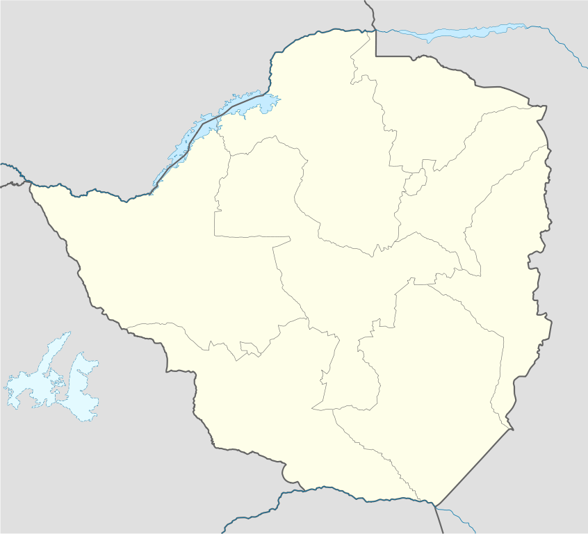
Deutsch: Positionskarte von Simbabwe
Quadratische Plattkarte, N-S-Streckung 105 %. Geographische Begrenzung der Karte:
English: Location map of Zimbabwe
Equirectangular projection, N/S stretching 105 %. Geographic limits of the map:
|
| Datum | |
| Bron |
own work, using
|
| Auteur | NordNordWest |
| Andere versies |
|


|
Deze kaart is gemaakt of verbeterd in de Duitse Kartenwerkstatt (Map Lab). Je kunt ook zelf kaarten ter verbetering voorstellen.
|
Licentie
Ik, de auteursrechthebbende van dit werk, maak het hierbij onder de volgende licenties beschikbaar:

|
Toestemming wordt verleend voor het kopiëren, verspreiden en/of wijzigen van dit document onder de voorwaarden van de GNU-licentie voor vrije documentatie, versie 1.2 of enige latere versie als gepubliceerd door de Free Software Foundation; zonder Invariant Sections, zonder Front-Cover Texts, en zonder Back-Cover Texts. Een kopie van de licentie is opgenomen in de sectie GNU-licentie voor vrije documentatie. |
Dit bestand is gelicenseerd onder de Creative Commons-licentie Naamsvermelding-Gelijk delen 3.0 Unported
- De gebruiker mag:
- Delen – het werk kopiëren, verspreiden en doorgeven
- Remixen – afgeleide werken maken
- Onder de volgende voorwaarden:
- naamsvermelding – U moet op een gepaste manier aan naamsvermelding doen, een link naar de licentie geven, en aangeven of er wijzigingen in het werk zijn aangebracht. U mag dit op elke redelijke manier doen, maar niet zodanig dat de indruk wordt gewekt dat de licentiegever instemt met uw werk of uw gebruik van zijn werk.
- Gelijk delen – Als u het werk heeft geremixt, veranderd, of erop heeft voortgebouwd, moet u het gewijzigde materiaal verspreiden onder dezelfde licentie als het oorspronkelijke werk, of een daarmee compatibele licentie.
U mag zelf één van de licenties kiezen.
Bestandsgeschiedenis
Klik op een datum/tijd om het bestand te zien zoals het destijds was.
| Datum/tijd | Miniatuur | Afmetingen | Gebruiker | Opmerking | |
|---|---|---|---|---|---|
| huidige versie | 13 aug 2008 19:49 | | 832 × 755 (193 kB) | NordNordWest | {{Information |Description= {{de|Positionskarte von Simbabwe}} Quadratische Plattkarte, N-S-Streckung 105 %. Geographische Begrenzung der Karte: * N: 15.2° S * S: 22.8° S * W: 24.8° O * O: 33.6° O {{en|Location map of [[:en:Zimbabwe|Z |
Bestandsgebruik
Geen enkele pagina gebruikt dit bestand.
Globaal bestandsgebruik
De volgende andere wiki's gebruiken dit bestand:
- Gebruikt op af.wikipedia.org
- Gebruikt op am.wikipedia.org
- Gebruikt op ar.wikipedia.org
- Gebruikt op az.wikipedia.org
- Gebruikt op ba.wikipedia.org
- Gebruikt op be-tarask.wikipedia.org
- Gebruikt op be.wikipedia.org
- Gebruikt op bg.wikipedia.org
- Gebruikt op bn.wikipedia.org
- Gebruikt op bs.wikipedia.org
- Gebruikt op ceb.wikipedia.org
Globaal gebruik van dit bestand bekijken.