
Gebruiker:Heinonlein/Koelkast/Vriezer
- ↓ 177.591
Chinese portretkunst (Q)[bewerken | brontekst bewerken]

De Chinese portretkunst is het oudste genre in de Chinese schilderkunst. De portretkunst kwam enkele eeuwen eerder in ontwikkeling dan populaire genres als vogel- en bloemschilderingen en shan shui-landschappen.
Geschiedenis[bewerken | brontekst bewerken]
De eerste Chinese afbeeldingen van personen waren puur functioneel; ze dienden als illustraties bij de leerstellingen van Confucius en als talismannen voor begraven edellieden. Vroege portretten zijn in de vorm van zijden rollen, gelakte voorwerpen en fresco's aangetroffen in koninklijke graftombes van de Han-dynastie (202 v.Chr.-220 na Chr.).
Zes Dynastieën (220–589)[bewerken | brontekst bewerken]
De teleurgang van het confucianistische systeem in de periode van de Zes Dynastieën (220–589) werd weerspiegeld in de taoïstische en boeddhistische thema's in de portretkunst. Dergelijke schilderwerken hadden een religieuze functie, maar de afgebeelde personen hadden sprekende gelaatsuitdrukkingen en kunstig geschilderde klederdracht. Men begon de portretkunst als een kunstvorm te bezien. De schilderkunst werd aan het keizerlijk hof tot de hoogst gewaardeerde kunsten gerekend en beoefend door zowel ongeschoolde aristocraten als door de literati, die hun ambtelijke functie hadden verkregen middels het Chinees examenstelsel.
De belangrijkste schilder in de Jin-dynastie (265-420) was Gu Kaizhi (ca. 344–ca. 406), een taoïstische amateurschilder uit een familie van literati in Nanjing. Hij schreef een aantal verhandelingen over de schilderkunst, waarin hij benadrukte dat de kleren en het uiterlijk in een portret van ondergeschikt belang zijn; het zijn de ogen die een werk bezieling geven.[1]
![Kopie van Nimf van de rivier de Luo door Gu Kaizhi[a]](/wiki/Bestand:Gu_Kaizhi-Nymph_of_the_Luo_River_(full),_Palace_Museum,_Beijing.jpg)
Zhang Sengyou (fl. ca. 500–550) was een belangrijke kunstschilder in de Liang-periode (502–557). Hij was een van de eerste Chinese kunstenaars die met succes boeddhistische fresco's vervaardigde, waaronder in de tempels in Nanjing. Geen van zijn werken is bewaard gebleven, maar verslagen en kopieën getuigen van een vrijer, expressievere schildersstijl dan de precisie van Gu Kaizhi.
Tang-dynastie (618–906)[bewerken | brontekst bewerken]

In de economische bloeiperiode tijdens de Tang-dynastie nam het aantal hofschilders toe. Yan Liben (ca. 601–673) schilderde in opdracht van de keizer historische taferelen en portretten van voormalige keizers. Ook Zhang Xuan (713–755) en Zhou Fang (ca. 730-800) verdienden hun geld met natuurgetrouwe schilderingen, zij staan bekend om hun gedetailleerde handrollen die het dagelijks leven van de hofdames tonen. Deze schilderingen werden zeer kleurrijk en gedetailleerd uitgevoerd in de gongbi-techniek.
De kunstschilder Wu Daozi (fl. 710–760) maakte naam met zijn expressieve portretten in zwarte gewassen inkt. Veel kunstenaars volgden zijn voorbeeld en vervaardigden monochrome portretten. Andere vernieuwers waren Wang Qia (?–ca. 805) en Gu Kuang (ca. 725–ca. 814), twee Zuid-Chinese thaoïsten die de inkt op hun doek spatten. Naar verluidt moest dit spontane proces het goddelijke scheppingsproces imiteren. Tijdens de chaotische tweede helft van de Tang-dynastie werden dergelijke excentrieke schildertechnieken een trend onder de portretschilders. Ze vonden navolging bij de chán-boeddhisten van de zuidelijke Sudden-school. Zij vonden dat verlichting een spontane, irrationele ervaring was die in de schilderkunst alleen door een vergelijkbare spontaniteit kon worden uitgebeeld. Een van hen was Guanxiu (832–912), een excentrieke monnik die boeddhistische heiligen op groteske wijze afbeeldde.
Vijf Dynastieën en Tien Koninkrijken (906–960)[bewerken | brontekst bewerken]

In de periode van de Vijf Dynastieën en Tien Koninkrijken werd Guanxiu's bizarre portretstijl verder ontwikkeld door Shi Ke (?–975), een zen-boeddhist uit Chengdu. In zijn thaoïstische en boeddhistische afbeeldingen in gewassen inkt trachtte hij zijn publiek te choqueren door grillige lijnen vervormde gezichten.
De portretten van de zuidelijke kunstenaars getuigen van het decadente hofleven van de tien koninkrijken. Zhou Wenju (917–975) schilderde in de kleurrijke stijl van Zhang Xuan en Zhou Fang gedetailleerde taferelen met hofdames die zich amuseren. Op de handrol Nachtelijke braspartij van Han Xizai stelde Gu Hongzhong (ca. 910–980) de uitspattingen van een minister van de Zuidelijke Tang-keizer Li Yu aan de kaak.[2]

Noordelijke Song (960–1127)[bewerken | brontekst bewerken]
_02.jpg)
In 960 werd China weer verenigd onder de Song-dynastie. Een van de belangrijkste portretschilders in de Noordelijke Song was Li Gonglin (ca. 1049–1106). Hij was jarenlang bezig met het kopiëren van de oude meesters en oefende zich in monochrome religieuze taferelen in een eenvoudige lijnvoering. Zijn stijl vond tot in de Ming-periode navolging.
Onder literati als Su Shi (1036–1101) en Mi Fu (1051–1107) ontstond de gewoonte om in kleine gezelschappen bij elkaar te komen en te discussiëren over elkaars kunstwerken. Su pleitte in deze kringen voor het combineren van de 'drie perfecties': de poëzie, kalligrafie en schilderkunst.
Su promootte ook het idee van een schilderwerk als een vorm van expressie, geen natuurgetrouwe afbeelding van de werkelijkheid. Een schildering moest volgens Su vooral inzicht geven in de emoties en ideeën van de maker, een gedachte die een fundamentele principe van de literati-schilderkunst werd.[3] Song Huizong, de laatste keizer van de Noordelijke Song, was een heel andere mening toegedaan. Hij drong er bij zijn hofschilders op aan om personen en objecten zo natuurgetrouw mogelijk af te beelden. De zo ontstane kloof tussen hofschilders en onafhankelijke literati zou eeuwenlang blijven bestaan.
Zuidelijke Song (1127–1279)[bewerken | brontekst bewerken]

Na de inval van de Jurchen vluchtte het keizerlijk hof in 1127 naar het zuiden van China. De eerste keizers van de Zuidelijke Song, Song Gaozong en Song Xiaozong, moedigden hun hofschilders aan tot het vervaardigen van historische en religieuze taferelen.
- Ma Yuan (ca. 1160–1225)
- Liu Songnian (1174–1224)
- Ma Lin (ca. 1180 – na 1256)
- Liang Kai (ca. 1140–ca. 1210)
- Qian Xuan (1235–1305)
De veranderde politieke situatie had onder andere een zichtbare invloed op de shan shui-landschappen. De literati waren meer geïnteresseerd in de neo-confucianistische filosofie van het opbouwen van de maatschappij vanaf de basis. Zij promootten bijvoorbeeld kleine privé-scholen die de grote, door de staat bestuurde academies zouden vervangen. Schilders als Ma Yuan (ca. 1160–1225) en Xia Gui (1195–1224) plaatsten gedetailleerde, intieme taferelen op de voorgrond die scherp contrasteerden met de massieve bergpartij op de achtergrond. De bergcontouren waren uitgevoerd in vervagende inktranden, zodat de indruk werd gewekt dat de bergen in een oneindige ruimte verdwenen. Aan dit idee van mystiek en onbereikbare grootsheid lag een Chinese filosofie ten grondslag; het taoïsme leert dat mensen slechts kleine vlekjes zijn vergeleken bij de weidse kosmos. De bergstroom diende als een schakel met zowel het afgebeelde tafereel als de kijker zelf. Ma en Xia legden met hun vernieuwende aanpak de basis voor de invloedrijke Ma-Xia-school.[4]
Tijdens de Song-periode werden kleine ronde schilderingen populair die in albums konden worden verzameld. Naast het schilderwerk kon een gedicht worden gekalligrafeerd die overeenkwam met het thema en de sfeer. In navolging van Su Shi streefde een groeiend aantal kunstschilders naar een vrije uiting van hun gevoelens en het proberen weer te geven van de innerlijke geest van het onderwerp, niet de uiterlijke verschijning. Zo ontstond er een nieuwe klasse van schilders die minder geschoold waren in schildertechnieken als trompe l'oeil, zoals onderwezen werd aan de gerenommeerde kunstacademies. Sommigen ontbeerden zelfs de vaardigheid van de schilders die leefden van de verkoop op marktplaatsen. Ondanks hun simpele schilderstijl bekritiseerde deze nieuwe klasse de hof- en beroepsschilders om hun perfectie en het feit dat zij geld ontvingen voor hun werk. Een dergelijke manier van schilderen was in de ogen van de minder geschoolden geen echte kunstvorm en niet beter dan het werk van slagers of ketellappers op de markt.[5]
Ondanks de opmars van de expressievere, minder technische schilderijen waren de technisch bekwame hofschilders nog steeds populair aan het keizerlijk hof. Een van hen was Zhang Zeduan (1085–1145), schilder van de handrol Langs de rivier tijdens het Qingmingfestival. Dit schilderwerk wordt door veel kunstcritici beschouwd als het beste werk van de Chinese schilderkunst en derhalve ook wel "China's Mona Lisa" genoemd.[6]
Yuan-dynastie (1279–1368)[bewerken | brontekst bewerken]
Nadat de Mongoolse Yuan-dynastie in 1279 aan de macht was gekomen, schafte zij het Chinees examenstelsel af en werden veel literati van hun post ontheven. Desondanks bloeide de schilderkunst nog steeds. Daar kunstenaars niet langer aan de strenge conventies van het examenstelsel waren gebonden, werden de schilderijen expressiever dan voorheen.[3] In deze tijd werd de gewoonte om een schilderij van een gekalligrafeerd gedicht te voorzien gemeengoed. Veel Mongoolse kans en hun families hadden grote bewondering hadden voor de Chinese kunst. Buyantu Khan, die met name een liefhebber was van de werken van Zhao Mengfu (1254–1322), voerde in 1315 het examenstelsel opnieuw in. Jayaatu Khan, die van 1329 tot 1332 over China regeerde, werd zelf een verdienstelijk schilder en kalligraaf in de Chinese traditie.
Ming-dynastie (1368–1644)[bewerken | brontekst bewerken]
- Zhou Chen (1460–1535)
- Du Jin (fl. ca. 1465–1509)
- Tang Yin (1470–1523)
- Wen Zhengming (1470–1559)
- Qiu Ying (ca. 1494–1552)
- Lan Ying (1585–1664)
- Chen Hongshou (1599–1652)
In 1368 verdreef de Chinese rebellenleider Zhu Yuanzhang de Yuan uit China en stichtte hij de Ming-dynastie. In deze periode, die te boek kwam te staan als "een van de grootste periodes van ordelijke regering en sociale stabiliteit in de menselijke geschiedenis",[7] werd aan het Chinese hof verder geborduurd op de oude schildertradities uit de Song-periode. Zhu Yuanzhang moest niets hebben van de individuele creativiteit die zo kenmerkend was voor de Yuan-periode, maar wenste technische perfectie.
Niet alle literati konden zich vinden in de strenge conventies van het Chinees examenstelsel en het hof.
De schilder en kalligraaf Dong Qichang (1555-1636) was een voorvechter van de belangeloze literatenkunst (wenrenhua). Hij maakte een onderscheid tussen de perfectionistische Noordelijke School van de hofschilders en de expressieve Zuidelijke School van onafhankelijke literati, waarvan hijzelf naar eigen zeggen de belangrijkste vertegenwoordiger was. Tot ver in de Qing-dynastie bleef een duidelijk onderscheid tussen beide scholen bestaan.
Tang Yin (1470-1523) en Qiu Ying (ca.1494-ca.1552) waren beide bevriend met Shen Zhou en When Zhengming. Gezamenlijk werden zij reeds in de Ming-periode tot de Vier Meesters van de Ming-dynastie gerekend, al waren Tang en Qiu geen geschoolde literati. Tang kon niet deelnemen aan het examenstelsel, daar hij van fraude werd beschuldigd. Hij legde zich toe op de schilderkunst en was bedreven in een groot aantal genres, van landschappen tot bamboeschilderingen. De autodidact Qiu was vooral geroemd om zijn kunstige shan shui-landschappen.
Qing-dynastie (1644–1912)[bewerken | brontekst bewerken]


- Shitao (1642–1707)
- Gao Qipei (1660–1734)
- Huang Shen (1687–1772)
- Jin Nong (1687–1764)
- Giuseppe Castiglione
- Luo Ping (1733–1799)
- Ren Xiong (1823–1857)
- Ren Bonian (1840–1896)
- Wu Changshuo (1844–1927)
Nadat Mantsjoerije in 1644 Peking had veroverd, kwam de Qing-dynastie aan de macht. Het Chinese rijk werd in de Qing-periode meer dan tweemaal zo groot als in de Ming-periode, maar desondanks groeide de gemiddelde levensstandaard. Rond de beginperiode van de Qing-dynastie verschenen de eerste handboeken die in kleurendruk de schilderkunst en Chinese kalligrafie behandelden.[b] Hierdoor konden steeds meer Chinezen zich toeleggen op de schilderkunst. Aan het hof legden de schilders van de Noordelijke School zich toe op werken die de keizers gunstig stemden, zoals portretten van de keizerlijke familie en taferelen van overwinningen in veldslagen. Er werden ook Europese schilders aan het hof ontboden, zoals Giuseppe Castiglione in 1715. Zij introduceerden elementen als perspectief en clair-obscur in de Chinese schilderkunst.
In de Zuidelijke School was men van mening dat deze vernieuwingen afbreuk deden aan de vitaliteit van een schilderij.

De progressieve school (Zuidelijke School) bestond in de beginjaren van de Qing-periode voornamelijk uit Ming-loyalisten die zich verzetten tegen de in hun ogen buitenlandse heerschappij. Veel literati gaven hun positie aan het hof op en werden zwervers, monniken of kluizenaars. Dit waren bijvoorbeeld de zogenoemde 'Vier Monniken': Hong Ren (1610–1664), Kun Can (1612–1673), Bada Shanren (1626–1705) en Shitao (1642–1707). Hun werken in gewassen inkt weerspiegelen de onafhankelijke en persoonlijke stijl die steeds gangbaarder werd onder de literati van de Zuidelijke School.[3] Ook de Acht Excentriekelingen van Yangzhou verwierpen de orthodoxe opvattingen over de schilderkunst ten bate van een expressiever stijl.
In de 18e eeuw groeiden belangrijke Chinese steden als Kanton, Yangzhou en Shanghai uit tot kunstcentra. Rijke kooplieden namen kunstschilders onder hun hoede en moedigde hen aan tot het maken van steeds gedurfdere werken. Nadat het Britse Rijk in 1842 de Eerste Opiumoorlog won, werden Chinese havens voor het westen geopend.[9] Aan het einde van de 19e eeuw nam de invloed van de westerse kunst nog meer toe doordat kunstenaars studiereizen maakten naar Europa en Japan, waar de westerse kunst al wijdverbreid was. Gao Jianfu (1879–1951), zijn broer Gao Qifeng (1889–1933) en Chen Shuren (1884–1948) mengden westerse technieken met traditionele stijlen en legden zo de basis voor de Lingnan-school, een van de invloedrijkste stromingen van die tijd.[10]
Desondanks bleef de Chinese schilderkunst zijn identiteit bewaren. In reactie op de massale import van Japanse en westerse boeken, foto's, lithografieën en kleurenposters ontstond er uiteindelijk een hernieuwde belangstelling voor de traditionele schilderkunst.[9] Een van de bekendste moderne Chinese schilders was Qi Baishi (1864–1957), een van oorsprong arme boer die voortborduurde op traditionele thema's. Hij maakte vooral naam met zijn afbeeldingen van bloemen en kleine dieren. Volgens hem moest een schilderij "het midden houden tussen gelijken en niet-gelijken".[11]
Moderne tijd (vanaf 1912)[bewerken | brontekst bewerken]

- Qi Baishi (1864–1957)
- Xu Beihong (1895–1953)
- Fu Baoshi (1904–1965)
In 1912 werd de laatste Chinese keizer van de troon gestoten en de Republiek China uitgeroepen. Al in de beginjaren van deze periode kwamen steeds meer kunstenaars in aanraking met westerse schilderstijlen- en technieken. In de jaren 20 maakten jonge kunstschilders studiereizen naar Parijs en Duitsland en verwerkten terug in China allerlei westerse stijlen in hun eigen kunst. Zo liet Xu Beihong (1895–1953) het Chinese publiek kennis maken met het realisme, Liu Haisu (1896–1994) met het postimpressionisme en Lin Fengmian (1900–1991) met de stijl van de fauvist Henri Matisse.[3] Zhang Daqian wordt door veel kunstkenners beschouwd als de meest toonaangevende Chinese kunstschilder van zijn tijd. Hij maakte zowel traditionele schilderijen als impressionistische en expressionistische werken.
De regering moedigde kunstenaars aan om op grote schaal schilderijen te maken in de stijl van het Russische socialistisch realisme. Deze trend zette zich tot in de jaren 50 voort. Na de campagne 'Laat Honderd Bloemen Bloeien' van premier Zhou Enlai in 1956 en 1957 kende de traditionele Chinese schilderkunst een kleine heropleving. Tijdens de Culturele Revolutie van 1966 tot 1976 werden de kunstacademies echter gesloten. Kunsttentoonstellingen werden verboden en een groot aantal kunstwerken werd vernietigd.
Na de arrestatie van de Bende van Vier in 1976 werden de kunstacademies weer geopend. Dankzij een groot aantal uitwisselingsprogramma's werden steeds meer westerse invloeden geïntroduceerd. Kunstenaars als Li Keran (1907–1989), Huang Yongyu (1924) en Wu Guanzhong (1919–2010) trachtten de Chinese schilderkunst met nieuwe motieven en technieken te vervolmaken. Deze trend zette zich tot in de 21e eeuw door. Zo combineert Shaoqiang Chen (1981) technieken van de Song- en Yuan-meesters met westerse innovaties als het vogelperspectief.
Bekende vertegenwoordigers[bewerken | brontekst bewerken]
- Zes Dynastieën (220–589)
- Gu Kaizhi (ca. 344–ca. 406)
- Zhang Sengyou (actief: 500–550)
- Zhan Ziqian (ca. 550–604)
- Tang-dynastie (618–906)
- Yan Liben (?–673)
- Wu Daozi (actief: 710–760)
- Zhang Xuan (713–755)
- Han Gan (ca. 715–781)
- Wang Qia (Wang Mo; ?–ca. 805)
- Gu Kuang (ca. 725–ca. 814)
- Zhou Fang (ca. 730–800)
- Guanxiu (832–912)
- Vijf Dynastieën en Tien Koninkrijken (907–960)
- Shi Ke (?–975)
- Zhou Wenju (917–975)
- Gu Hongzhong (937–975)
- Song-dynastie (960–1270)
- Li Gonglin (ca. 1049–1106)
- Mi Fu (1051–1107)
- Ma Yuan (ca. 1160–1225)
- Liu Songnian (1174–1224)
- Ma Lin (ca. 1180 – na 1256)
- Liang Kai (ca. 1140–ca. 1210)
- Qian Xuan (1235–1305)
- Yuan-dynastie (1279–1368)
- Ming-dynastie (1368–1644)
- Zhou Chen (1460–1535)
- Du Jin (fl. ca. 1465–1509)
- Tang Yin (1470–1523)
- Wen Zhengming (1470–1559)
- Qiu Ying (ca. 1494–1552)
- Lan Ying (1585–1664)
- Chen Hongshou (1599–1652)
- Qing-dynastie (1644–1912)
- Shitao (1642–1707)
- Gao Qipei (1660–1734)
- Huang Shen (1687–1772)
- Jin Nong (1687–1764)
- Giuseppe Castiglione
- Luo Ping (1733–1799)
- Ren Xiong (1823–1857)
- Ren Bonian (1840–1896)
- Wu Changshuo (1844–1927)
- Moderne tijd (vanaf 1912)
- Qi Baishi (1864–1957)
- Xu Beihong (1895–1953)
- Fu Baoshi (1904–1965)
Noten
Bronnen
|
Categorie:Chinese schilderkunst
Amazoneregenwoud (forest, river & basin) [bewerken | brontekst bewerken]


Het Amazoneregenwoud (Braziliaans-Portugees: Floresta Amazônica of Floresta Amazônia, Spaans: Selva Amazónica of Selva Amazonía) is een tropisch regenwoud in de Amazonebekken, gelegen in het noorden van Zuid-Amerika. Ruim 5,5 miljoen vierkante kilometer van dit stroomgebied van de Amazone en haar zijrivieren is bedekt met het regenwoud. Het Amazoneregenwoud is hiermee grootste regenwoud op aarde en heeft een oppervlakte gelijk aan die van de overige regenwouden tezamen.[1] Het is bovendien het regenwoud met de grootste biodiversiteit.
Geografie[bewerken | brontekst bewerken]

Het Amazoneregenwoud ligt in het Amazonebekken, een stroomgebied dat met een oppervlakte van ruim 7 miljoen vierkante kilometer het grootste deel van noordelijk Zuid-Amerika beslaat. Het Amazonebekken wordt bevloeid door de omliggende hooggebergtes. Ten westen van het gebied ligt de Andes. Hier bevinden zich de voornaamste bronnen van de bovenloop van de Amazone, de langste rivier in Amerika. Ten noorden van het stroomgebied ligt het Hoogland van Guyana en ten oosten het Hoogland van Brazilië. Ook hier ontspringen tal van zijrivieren van de Amazone. De rivierdelta bevindt zich bijna drieduizend kilometer ten oosten van de Andes, aan de Braziliaanse kust van de Atlantische Oceaan.
Het Amazoneregenwoud beslaat ongeveer 5,5 miljoen vierkante kilometer, ruim driekwart van het Amazonebekken. 60 procent van het regenwoud ligt in Brazilië, gevolgd door Peru (13%), Colombia (10%) en kleine delen in Venezuela, Ecuador, Bolivia, Guyana, Suriname en Frans-Guyana.[2]

Het bekken wordt omgeven door het Hoogland van Guyana in het noorden, de Andes in het westen en het Hoogland van Brazilië in het zuiden en oosten. In vroegere geologische tijden is dit gebied een binnenzee geweest. Nadat de Andes was gevormd werd het opgevuld door de sedimenten van rivieren zoals de Amazone, de Rio Negro en de Rio Madeira.
De Amazone ontspringt in Peru en mondt na 6525 kilometer uit in de Atlantische oceaan. Langs de Amazone ligt het Amazoneregenwoud of selva, het grootste tropische regenwoud in de wereld. Het gebied heeft een tropisch regenwoudklimaat en aan de randen een moessonklimaat.
Twee keer per jaar overstroomt dit gebied zo erg dat vele rivieren met elkaar in verbinding komen te staan. Dit gebeuren wordt het wassen van het water genoemd. Verder komen er het hele jaar door moerassen voor elk ter grootte van de Benelux. Men kan zich dan ook het Amazonebekken voorstellen als een uitgestrekt bekken dat permanent met water gevuld is.
- Bovenloop ===
De Amazone ontspringt op 5200 meter hoogte in de Andes. Bij de bovenloop draagt ze de naam Apurímac. De in Peru gelegen gletsjer die als bron van de Amazone wordt gezien ligt op maar 190 kilometer van de Grote Oceaan, tegenover duizenden kilometers van de Atlantische Oceaan. Al snel vloeit de Amazone, die dan nog verschillende namen draagt (waarvan Marañón de bekendste is), samen met tientallen andere rivieren, waarvan de Ucayali de grootste is. Eenmaal in Brazilië aangekomen, is de Amazone aangewassen tot een reusachtige waterstroom die rustig door het Amazonebekken stroomt.
- Middenloop ===
Verder stroomafwaarts krijgt de Amazone vanuit het noorden een grote toevoer van water vanuit het Hoogland van Guyana. Hiervan is de Rio Negro, die bij de Encontro das Águas (ontmoeting van wateren) in de Amazone uitmondt, de grootste leverancier. Uit het zuiden krijgt ze ook een zeer grote toevoer van water uit het Hoogland van Bolivia en het Hoogland van Brazilië. Het zijn met name de Rio Purús en de Rio Madeira die hieraan bijdragen.
- Monding ===
Wanneer de Amazone uiteindelijk in de Atlantische Oceaan stroomt, bevat ze het water van ruim 1100 zijrivieren. Per seconde voert de Amazone op deze wijze 190.000 kubieke meter water naar de oceaan. Deze waterstroom heeft in de loop van miljoenen jaren een submariene canyon op de oceaanbodem uitgesleten van enkele honderden kilometers lengte. Het geel gekleurde water van de Amazone is tot 320 kilometer uit de kust te onderscheiden van overig zeewater. De monding van de Amazone is meer dan 330 km breed.
- Plaatsen==
De grootste plaatsen aan de Amazone zijn Manaus, Pucallpa (aan de bronrivier Ucayali), Iquitos, Macapá, en Santarém.
- Zijrivieren==
De Amazone heeft meer dan 1100 zijrivieren, waarvan er ongeveer 100 bevaarbaar zijn. 17 zijrivieren zijn langer dan 1500 km.
- Lijst van de belangrijkste zijrivieren ===

- 3250 km – Madeira, Bolivia/Brazilië
- 3211 km – Purus, Peru/Brazilië
- 2820 km – Japurá, Colombia/Brazilië[3]
- 2639 km – Tocantins, Brazilië[4]
- 2627 km – Araguaia, Brazilië (zijriver van de Tocantins)[5]
- 2400 km – Juruá, Peru/Brazilië
- 2250 km – Rio Negro, Brazilië/Venezuela/Colombia
- 1992 km – Tapajós, Brazilië[6]
- 1979 km – Xingu, Brazilië[7]
- 1900 km – Ucayali (rivier), Peru
- 1749 km – Guaporé, Brazilië/Bolivia (zijriver van de Madeira)[8]
- 1575 km – Putumayo, Colombia/Ecuador/Peru/Brazilië
- 1415 km – Marañón, Peru
- 1370 km – Teles Pires, Brazilië (zijriver van de Tapajós)
- 1300 km – Iriri, Brazilië (zijriver van de Xingu)
- 1240 km – Juruena, Brazil (zijriver van de Tapajós)
- 1130 km – Madre de Dios, Peru/Bolivia (zijriver van de Madeira)
- 1100 km – Huallaga, Peru (zijriver van de Marañón)
- Kleur van de zijrivieren ===
Het stelsel van de vele zijrivieren van de Amazone valt in twee soorten uiteen: rivieren met geel water en zwartwaterrivieren. De gele rivieren komen uit het zuidoosten van het Amazonebekken en ontspringen in de Andes van Peru. Deze zijrivieren voeren veel sediment aan afkomstig van snelstromende bergriviertjes. Dit sediment wordt in suspensie naar de Atlantische Oceaan gevoerd. De donkere zijrivieren komen uit het noorden van het Amazonegebied in gebieden zoals het Hoogland van Guyana, tropisch en relatief vlak gebied, waar daarom weinig erosie plaatsvindt. De Rio Negro of "zwarte rivier" vormt daar een voorbeeld van.
The Amazon River rises in the Andes Mountains at the west of the basin with its main tributary the Marañón River in Peru. It is usually considered to be the second longest river in the world.[9] However, a team of Brazilian scientists has claimed that the Amazon is the longest river in the world.[10] It covers about 6,400 km before draining into the Atlantic Ocean. The Amazon and its tributaries form the largest volume of water. The Amazon accounts for about 20% of the total water carried to the oceans by rivers. Some of the Amazon rainforests are deforested because of the increasing of cattle ranches and soy beans field.
The highest point in the watershed of the Amazon is the peak of Yerupajá at 6,635 m (21,768 ft).
The Amazon basin formerly flowed west to Pacific Ocean until the Andes formed, causing the basin to flow eastward towards the Atlantic Ocean.[11]
Politically the basin is divided into the Brazilian Amazônia Legal, the Peruvian Amazon, the Amazon region of Colombia and parts of Bolivia, Ecuador and the Venezuelan state of Amazonas.
The Amazon River originated as a transcontinental river in the Miocene Epoch between 11.8 million and 11.3 million years ago and took its present shape approximately 2.4 million years ago.
The Amazon once flowed west as part of a proto-Amazon-Congo river system, from the interior of present-day Africa when the continents were joined as western Gondwana. Fifteen million years ago, the Andes were formed by the collision of the South American plate with the Nazca plate. The rise of the Andes and the linkage of the Brazilian and Guyana bedrock shields, blocked the river and caused the Amazon to become a vast inland sea. Gradually this inland sea became a massive swampy, freshwater lake and the marine inhabitants adapted to life in freshwater. For example, over 20 species of stingray, most closely related to those found in the Pacific Ocean, can be found today in the freshwaters of the Amazon.
Ten to eleven million years ago, waters worked through the sandstone from the west and the Amazon began to flow eastward, leading to the emergence of the Amazon rainforest. During Ice Ages, sea levels dropped and the great Amazon lake rapidly drained and became a river, which would eventually become the world's largest, draining the most extensive expanse of rainforest on the planet.[12]

States or departments in four nations contain "Amazonas" in their names.
het grootste regenwoud op Aarde. Het heeft een oppervlakte van 5.5 miljoen km² en is verspreid over negen landen: Brazilië (60%), Peru (13%), Colombia (9%), Venezuela (5%), Bolivia (5%), Guyana (3%), Suriname (2,0%), Ecuador (1,5%) en Frans-Guyana (1,5%). Meer dan de helft van al het overgebleven regenwoud op aarde ligt in de Amazonebekken.
Het regenwoud ligt in een bekken dat grotendeels door de rivier de Amazone en zijn 1100 zijrivieren wordt doorstroomd. Dit bekken werd gevormd tijdens het Paleozoïcum, tussen de 200 en 500 miljoen jaar geleden.
- Origins ===


The most distant source of the Amazon was thought to be in the Apurímac river drainage for nearly a century. Such studies continued to be published even recently, such as in 1996,[13] 2001,[14] 2007,[15] and 2008,[16] where various authors identified the snowcapped 5,597 Nevado Mismi peak, located roughly 160 west of Lake Titicaca and 700 southeast of Lima, as the most distant source of the river. From that point, Quebrada Carhuasanta emerges from Nevado Mismi, joins Quebrada Apacheta and soon forms Río Lloqueta which becomes Río Hornillos and eventually joins the Río Apurímac.
A 2014 study by Americans James Contos and Nicolas Tripcevich in Area, a peer-reviewed journal of the Royal Geographic Society, however, identifies the most distant source of the Amazon as actually being in the Río Mantaro drainage. A variety of methods were used to compare the lengths of the Mantaro river vs. the Apurímac river from their most distant source points to their confluence, showing the longer length of the Mantaro. Then distances from Lago Junín to several potential source points in the uppermost Mantaro river were measured, which enabled them to determine that the Cordillera Rumi Cruz was the most distant source of water in the Mantaro basin (and therefore in the entire Amazon basin). The most accurate measurement method was direct GPS measurement obtained by kayak descent of each of the rivers from their source points to their confluence (performed by Contos). Obtaining these measurements was difficult given the class IV–V nature of each of these rivers, especially in their lower "Abyss" sections. Ultimately, they determined that the most distant point in the Mantaro drainage is nearly 80 km farther upstream compared to Mt. Mismi in the Apurímac drainage, and thus the maximal length of the Amazon river is about 80 km longer than previously thought. Contos continued downstream to the ocean and finished the first complete descent of the Amazon river from its newly identified source (finishing November 2012), a journey repeated by two groups after the news spread.[17]
After about 700, the Apurímac then joins Río Mantaro to form the Ene, which joins the Perene to form the Tambo, which joins the Urubamba to form the Ucayali. After the confluence of Apurímac and Ucayali, the river leaves Andean terrain and is surrounded by floodplain. From this point to the confluence of the Ucayali and the Marañón, some 1,600, the forested banks are just above the water and are inundated long before the river attains its maximum flood stage. The low river banks are interrupted by only a few hills, and the river enters the enormous Amazon rainforest.
- The Upper Amazon or Solimões ===
.jpg)
Although the Ucayali–Marañón confluence is the point at which most geographers place the beginning of the Amazon River proper, in Brazil the river is known at this point as the Solimões das Águas. The river systems and flood plains in Brazil, Peru, Ecuador, Colombia and Venezuela, whose waters drain into the Solimões and its tributaries, are called the "Upper Amazon".
The Amazon proper runs mostly through Brazil and Peru, and is part of the border between Colombia and Perú. It has a series of major tributaries in Colombia, Ecuador and Peru, some of which flow into the Marañón and Ucayali, and others directly into the Amazon proper. These include rivers Putumayo, Caquetá, Vaupés, Guainía, Morona, Pastaza, Nucuray, Urituyacu, Chambira, Tigre, Nanay, Napo, and Huallaga.
At some points the river divides into anabranches, or multiple channels, often very long, with inland and lateral channels, all connected by a complicated system of natural canals, cutting the low, flat igapó lands, which are never more than 5 metres (16 above low river, into many islands.
From the town of Canaria at the great bend of the Amazon to the Negro, vast areas of land are submerged at high water, above which only the upper part of the trees of the sombre forests appear. Near the mouth of the Rio Negro to Serpa, nearly opposite the river Madeira, the banks of the Amazon are low, until approaching Manaus, they rise to become rolling hills.
- The Lower Amazon ===


The Lower Amazon begins where the darkly colored waters of the Rio Negro meet the sandy colored Rio Solimões, and for over 6 these waters run side by side without mixing.
At Óbidos, a bluff 17 above the river is backed by low hills. The lower Amazon seems to have once been a gulf of the Atlantic Ocean, the waters of which washed the cliffs near Óbidos.
Only about ten percent of the Amazon's water enters downstream of Óbidos, very little of which is from the northern slope of the valley. The drainage area of the Amazon basin above Óbidos city is about 5,000,000 square kilometres (1,900,000, and, below, only about 1,000,000 square kilometres (390,000 (around 20%), exclusive of the 1,400,000 square kilometres (540,000 of the Tocantins basin. The Tocantins River enters the southern portion of the Amazon delta.
In the lower reaches of the river, the north bank consists of a series of steep, table-topped hills extending for about 240 kilometres (150 from opposite the mouth of the Xingu as far as Monte Alegre. These hills are cut down to a kind of terrace which lies between them and the river.
On the south bank, above the Xingu, a line of low bluffs bordering the floodplain extends nearly to Santarém in a series of gentle curves before they bend to the southwest, and, abutting upon the lower Tapajós, merge into the bluffs which form the terrace margin of the Tapajós river valley.
- Mouth ===

Belém is the major city and port at the mouth of the river at the Atlantic Ocean. The definition of where exactly the mouth of the Amazon is located, and how wide it is, is a matter of dispute, because of the area's peculiar geography. The Pará and the Amazon are connected by a series of river channels called furos near the town of Breves; between them lies Marajó, the world's largest combined river/sea island.
If the Pará river and the Marajó island ocean frontage are included, the Amazon estuary is some 325 kilometres (202 wide. In this case, the width of the mouth of the river is usually measured from Cabo Norte, the cape located straight east of Pracuúba in the Brazilian state of Amapá, to Ponta da Tijoca near the town of Curuçá, in the state of Pará.
A more conservative measurement excluding the Pará river estuary, from the mouth of the Araguari River to Ponta do Navio on the northern coast of Marajó, would still give the mouth of the Amazon a width of over 180 kilometres (110. If only the river's main channel is considered, between the islands of Curuá (state of Amapá) and Jurupari (state of Pará), the width falls to about 15 kilometres (9.3.
The plume generated by the river's discharge covers up to 1.3 million square kilometers and is responsible for muddy bottoms influencing a wide area of the tropical North Atlantic in terms of salinity, pH, light penetration, and sedimentation.
- Dispute regarding length ===
While debate as to whether the Amazon or the Nile is the world's longest river has gone on for many years, the historic consensus of geographic authorities has been to regard the Amazon as the second longest river in the world, with the Nile being the longest. However, the Amazon has been measured by different geographers as being anywhere between 6,259 and 6,992 kilometres (3,889 and 4,345 long. It is often said to be "at least" 6,400 kilometres (4,000 long.[18] The Nile is reported to be anywhere from 5,499 to 6,690 kilometres (3,417 to 4,157. Often it is said to be "about" 6,650 kilometres (4,130 long.[19] There are many factors that can affect these measurements.

A study by Brazilian scientists concluded that the Amazon is actually longer than the Nile. Using Nevado Mismi, which in 2001 was labeled by the National Geographic Society as the Amazon's source, these scientists made new calculations of the Amazon's length. They calculated the Amazon's length as 6,992 kilometres (4,345. Using the same techniques, they calculated the length of the Nile as 6,853 kilometres (4,258, which is longer than previous estimates but still shorter than the Amazon. They made it possible by measuring the Amazon downstream to the beginning of the tidal estuary of Canal do Sul and then, after a sharp turn back, following tidal canals surrounding the isle of Marajó and finally including the marine waters of the Río Pará bay in its entire length.[20] Guido Gelli, director of science at the Brazilian Institute of Geography and Statistics (IBGE), told the Brazilian TV network Globo in June 2007 that it could be considered as a fact that the Amazon was the longest river in the world. However, other geographers have had access to the same data since 2001, and a consensus has yet to emerge to support the claims of these Brazilian scientists. The length of both the Amazon and the Nile remains open to interpretation and continued debate.
6,259 km (3,889 mi) to 6,992 km (4,345 mi) – Amazon, South America[59] 3,250 km (2,020 mi) – Madeira, Bolivia/Brazil[60] 3,211 km (1,995 mi) – Purús, Peru/Brazil[61] 2,820 km (1,750 mi) – Japurá or Caquetá, Colombia/Brazil[62] 2,639 km (1,640 mi) – Tocantins, Brazil[63] 2,627 km (1,632 mi) – Araguaia, Brazil (tributary of Tocantins)[64] 2,400 km (1,500 mi) – Juruá, Peru/Brazil[65] 2,250 km (1,400 mi) – Rio Negro, Brazil/Venezuela/Colombia[66] 1,992 km (1,238 mi) – Tapajós, Brazil[67] 1,979 km (1,230 mi) – Xingu, Brazil[68] 1,900 km (1,200 mi) – Ucayali River, Peru[69] 1,749 km (1,087 mi) – Guaporé, Brazil/Bolivia (tributary of Madeira)[70] 1,575 km (979 mi) – Içá (Putumayo), Ecuador/Colombia/Peru 1,415 km (879 mi) – Marañón, Peru 1,370 km (850 mi) – Teles Pires, Brazil (tributary of Tapajós) 1,300 km (810 mi) – Iriri, Brazil (tributary of Xingu) 1,240 km (770 mi) – Juruena, Brazil (tributary of Tapajós) 1,130 km (700 mi) – Madre de Dios, Peru/Bolivia (tributary of Madeira) 1,100 km (680 mi) – Huallaga, Peru (tributary of Marañón)
Hydrologie en klimaat[bewerken | brontekst bewerken]

in juli en januari


- stroomgebied 40% Z-A; 1/5 van rivierwater ter wereld[21]
- 2500-4000 mm per jaar, tot wel 12.000 op sommige plaatsen[21]
- 20-32 C


The Amazon River (US /ˈæməzɒn/ or UK /ˈæməzən/; Spanish and Amazonas) in South America is the largest river by discharge of water in the world, and according to some experts, the longest in length.
The headwaters of the Apurímac River on Nevado Mismi had been considered for nearly a century as the Amazon’s most distant source, until a 2014 study found it to be the Cordillera Rumi Cruz at the headwaters of the Mantaro River in Peru.[22] The Mantaro and Apurímac confluence, and with other tributaries form the Ucayali River, which in turn confluences with the Marañón River upstream of Iquitos, Peru, to form what countries other than Brazil consider to be the main stem of the Amazon. Brazilians call this section the Solimões River above its confluence with the Rio Negro[23] to form what Brazilians call the Amazon at the Meeting of Waters (Encontro das Águas) at Manaus, the river's largest city.
At an average discharge of about 209,000 cubic metres per second (7,400,000—approximately 6,591 cubic kilometres per annum (1,581, greater than the next seven largest independent rivers combined—the Amazon represents 20% of the global riverine discharge to the ocean.[24] The Amazon basin is the largest drainage basin in the world, with an area of approximately 7,050,000 square kilometres (2,720,000. The portion of the river's drainage basin in Brazil alone is larger than any other river's basin. The Amazon enters Brazil with only one-fifth of the flow it finally discharges into the Atlantic Ocean, yet already has a greater flow at this point than the discharge of any other river.[25][26]
The Amazon River basin has a low-water season, and a wet season during which, the rivers flood the adjacent, low-lying forests. The climate of the basin is generally hot and humid. In some areas, however, the winter months (June–September) can bring cold snaps, fueled by Antarctic winds travelling along the adjacent Andes mountain range. Such cold conditions can be devastating for some of the region's tropical plant and animal species.[27]
The Amazon basin, the largest in the world, covers about 40% of South America, an area of approximately 7,050,000 square kilometres (2,722,020. It drains from west to east, from Iquitos in Peru, across Brazil to the Atlantic. It gathers its waters from 5 degrees north latitude to 20 degrees south latitude. Its most remote sources are found on the inter-Andean plateau, just a short distance from the Pacific Ocean. The locals often refer to it as "El Jefe Negro", referring to an ancient god of fertility.
The Amazon River and its tributaries are characterized by extensive forested areas that become flooded every rainy season. Every year, the river rises more than 9 metres (30, flooding the surrounding forests, known as várzea ("flooded forests"). The Amazon's flooded forests are the most extensive example of this habitat type in the world.[28] In an average dry season, 110,000 square kilometres (42,000 of land are water-covered, while in the wet season, the flooded area of the Amazon basin rises to 350,000 square kilometres (140,000.[29]
The quantity of water released by the Amazon to the Atlantic Ocean is enormous: up to 300,000 cubic metres per second (11,000,000 in the rainy season, with an average of 209,000 cubic metres per second (7,400,000 from 1973 to 1990.[30] The Amazon is responsible for about 20% of the Earth's fresh water entering the ocean. The river pushes a vast plume of fresh water into the ocean. The plume is about 400 kilometres (250 long and between 100 and 200 kilometres (62 and 124 wide. The fresh water, being lighter, flows on top of the seawater, diluting the salinity and altering the color of the ocean surface over an area up to 2,500,000 in extent. For centuries ships have reported fresh water near the Amazon's mouth yet well out of sight of land in what otherwise seemed to be the open ocean.
The Atlantic has sufficient wave and tidal energy to carry most of the Amazon's sediments out to sea, thus the Amazon does not form a true delta. The great deltas of the world are all in relatively protected bodies of water, while the Amazon empties directly into the turbulent Atlantic.
There is a natural water union between the Amazon and the Orinoco basins, the so-called Casiquiare canal. The Casiquiare is a river distributary of the upper Orinoco, which flows southward into the Rio Negro, which in turn flows into the Amazon. The Casiquiare is the largest river on earth that links two major river systems, a so-called bifurcation.
- Flooding ===

Not all of the Amazon's tributaries flood at the same time of the year. Many branches begin flooding in November and may continue to rise until June. The rise of the Rio Negro starts in February or March and begins to recede in June. The Madeira River rises and falls two months earlier than most of the rest of the Amazon.
The depth of the Amazon between Manacapuru and Óbidos has been calculated as between 20 to 26 metres (66 to 85. At Manacapuru, the Amazon's water level is only about 24 metres (79 above mean sea level. More than half of the water in the Amazon downstream of Manacapuru is below sea level.[31] In its lowermost section, the Amazon's depth averages 20 to 50 metres (66 to 164, in some places as much as 100 metres (330.[32]
The main river is navigable for large ocean steamers to Manaus, 1,500 kilometres (930 upriver from the mouth. Smaller ocean vessels of 3,000 tons or 9,000 tons[33] and 5.5 metres (18 draft can reach as far as Iquitos, Peru, 3,600 kilometres (2,200 from the sea. Smaller riverboats can reach 780 kilometres (480 higher as far as Achual Point. Beyond that, small boats frequently ascend to the Pongo de Manseriche, just above Achual Point.
Annual flooding occurs in late winter at high tide when the incoming waters of the Atlantic are funnelled into the Amazon delta. The resulting undular tidal bore is called the pororoca, with a leading wave that can be up to 25 feet (7.6 high and travel up to 500 miles (800 inland.[34][35]
Biodiversiteit[bewerken | brontekst bewerken]
Van alle biomen bevatten de tropische regenwouden de grootste biodiversiteit. De regenwouden van het Neotropisch gebied, oftewel Midden- en Zuid-Amerika, kennen een grotere soortendichtheid dan die van Afrika en Azië.[36] Als grootste Amerikaans regenwoud heeft het Amazoneregenwoud een ongeëvenaard aantal soorten planten en dieren. Een op de tien beschreven soorten komen hier voor.[37]
Flora[bewerken | brontekst bewerken]
Het Amazoneregenwoud kent de grootste biodiversiteit van plantensoorten op aarde. Er komen tenminste 40.000 plantensoorten voor, waarvan 16.000 boomsoorten. Volgens een schatting in 2013 bevat het Amazoneregenwoud zo'n 390 miljard bomen.[38]
- , bromelia's
-
 Heliconia
.jpg)
Uitpluizen (incl. subpagina's):
- (en) Mongabay.com: Rhett Butler, Amazon Wildlife
- (en) Mongabay.com: Rhett Butler, The Amazon Rainforest
- (en) WWF: Tropical and subtropical moist broadleaf forests
...with one 2001 study finding a quarter square kilometer (62 acres) of Ecuadorian rainforest supports more than 1,100 tree species.[39] A study in 1999 found one square kilometer (247 acres) of Amazon rainforest can contain about 90,790 tonnes of living plants. The average plant biomass is estimated at 356 ± 47 tonnes per hectare.[40] To date, an estimated 438,000 species of plants of economic and social interest have been registered in the region with many more remaining to be discovered or catalogued.[41] The total number of tree species in the region is estimated at 16,000.
.jpg)
The green leaf area of plants and trees in the rainforest varies by about 25% as a result of seasonal changes. Leaves expand during the dry season when sunlight is at a maximum, then undergo abscission in the cloudy wet season. These changes provide a balance of carbon between photosynthesis and respiration.[42]
Plant growth is dense and its variety of animal inhabitants is comparatively high due to the heavy rainfall and the dense and extensive evergreen and coniferous forests. The sunlight can not reach the ground because of the dense roof created by plants. The ground remains dark and damp and only shade tolerant trees and vegetation will grow here. Orchids and bromeliads exploit trees and other plants to get closer to the sunlight. They grow hanging onto the branches or tree trunks with aerial roots, not as parasites but as epiphytes. The most known species of tropical fruit tree that are native to the Amazon are Brazil nut(Castanha do Pará), Cocoa, Rubber tree, Assai palm. The Amazon basin contains thousands of plant species. The bromeliads are special in that they hold water, and frogs may use these plants to hatch their eggs, besides many other living organisms that have their homes in them.The kapok tree is the biggest tree of the Amazon rainforest, as it can grow to 200 feet tall and the trunk can be 10 or 11 feet in diameter and it grows on Varzea, which represents only about 10% of the entire basin. Most of the large Kapok trees have been cut and used as buoy to transport the valuable species of hardwood trees.
De diversiteit van plantsoorten is de hoogste ter wereld. Sommige deskundigen schatten dat één vierkante kilometer meer dan 75.000 type bomen en 150.000 soorten hogere planten kan bevatten. Eén vierkante kilometer Amazoneregenwoud kan ongeveer 75.000 ton levende planten herbergen.
Fauna[bewerken | brontekst bewerken]
The region is home to about 2.5 million insect species,[43] and some 2,000 birds and mammals. To date, 2,200 fishes,[44] 1,294 birds, 427 mammals, 428 amphibians, and 378 reptiles have been scientifically classified in the region.[45] One in five of all the bird species in the world live in the rainforests of the Amazon, and one in five of the fish species live in Amazonian rivers and streams. Scientists have described between 96,660 and 128,843 invertebrate species in Brazil alone.[46]
In het regenwoud leven ongeveer 100 miljoen insectensoorten, honderdduizenden plantensoorten, en bijna 2.000 soorten vogels en zoogdieren. Eén op de vijf van alle vogels in de wereld leeft in de regenwouden van de Amazone. Tot op heden zijn er 438.000 plantensoorten van economisch en sociaal belang in het gebied geregistreerd, maar daarnaast moeten er nog een hoop soorten worden geregistreerd, ontdekt of gecatalogiseerd.
The rainforest contains several species that can pose a hazard. Among the largest predatory creatures are the black caiman, jaguar, cougar, and anaconda. In the river, electric eels can produce an electric shock that can stun or kill, while piranha are known to bite and injure humans.[47] Various species of poison dart frogs secrete lipophilic alkaloid toxins through their flesh. There are also numerous parasites and disease vectors. Vampire bats dwell in the rainforest and can spread the rabies virus.[48] Malaria, yellow fever and Dengue fever can also be contracted in the Amazon region.
More than one-third of all known species in the world live in the Amazon rainforest,[49] a giant tropical forest and river basin with an area that stretches more than 5,400,000 square kilometres (2,100,000. It is the richest tropical forest in the world in terms of biodiversity. There are over 3,000 species of fish currently recognized in the Amazon basin, with more being discovered every year.[50] In addition to the thousands of species of fish, the river supports crabs, algae, and turtles.
Zoogdieren[bewerken | brontekst bewerken]
- luiaards, poema, jaguar, ocelot, miereneters, tapirs, capybara, Orinocodolfijn, Amazonelamantijn, reuzenotter, apen (nachtapen, brulapen, capucijnapen, doodshoofdaapjes, etc.), halfapen, vleermuizen (gewone vampier), kinkajoe
- ruim 500 zoogdiersoorten[21]

.JPG)
_(9714001143).jpg)


Along with the Orinoco, the Amazon is one of the main habitats of the boto, also known as the Amazon river dolphin (Inia geoffrensis). It is the largest species of river dolphin, and it can grow to lengths of up to 2.6 metres (8. The color of its skin changes with age; young animals are gray, but become pink and then white as they mature. The dolphins use echolocation to navigate and hunt in the river's tricky depths.[51] The boto is the subject of a legend in Brazil about a dolphin that turns into a man and seduces maidens by the riverside.
The tucuxi (Sotalia fluviatilis), also a dolphin species, is found both in the rivers of the Amazon basin and in the coastal waters of South America. The Amazonian manatee (Trichechus inunguis), also known as "seacow", is found in the northern Amazon River Basin and its tributaries. It is a mammal and a herbivore. Its population is limited to fresh water habitats, and, unlike other manatees, it does not venture into salt water. It is classified as vulnerable by the International Union for Conservation of Nature.
The Amazon and its tributaries are the main habitat of the giant otter (Pteronura brasiliensis). It is a member of the weasel family and is the largest of its kind. Because of habitat destruction and hunting, its population has dramatically decreased.
More than 1,400 species of mammals are found in the Amazon, the majority of which are species of bats and rodents. Its larger mammals include the jaguar, ocelot, capybara and South American tapir.
Vogels[bewerken | brontekst bewerken]
- 30% van alle vogelsoorten[21]
- Amerikaanse nachtzwaluw (overwinteraar), grijze reuzennachtzwaluw, pauraque, Verreaux' duif, muskuseend, Orinocogans, Amerikaans purperhoen, trompetvogel, zonneral, koerlan, kleine fuutkoet, tinamoes (grote tinamoe, kleine tinamoe), Amerikaanse slangenhalsvogel, zwartkeeltrogon, maskertrogon, blauwkapmotmot, groene ijsvogel, jabiroe,
- roeipotigen: rosse tijgerroerdomp, schuitbekreiger, Amerikaanse kleine zilverreiger
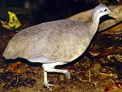
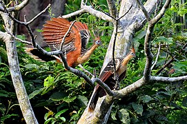
- koekoeksvogels: fazantkoekoek, eekhoornkoekoek, hoatzin,
- uilen: briluil, Braziliaanse dwerguil, kerkuil, Braziliaanse dwerguil, kuifuil
- roofvogels: harpij Amerikaanse schaarbek, zwarte gier, koningsgier, roodkopgier, lachvalk, zwaluwstaartwouw, slakkenwouw, langpootkiekendief, grote bonte buizerd, moerasbuizerd, savannebuizerd, wurgarend,
- kolibries: muskietkolibrie, oostelijke langstaartheremietkolibrie, regenboogamazilia
Vooral:
- spechtvogels (toekans en spechten): roodstaartglansvogel, bruinoorarassari, reuzentoekan, gestreepte helmspecht, grote glansvogel, zwartvoorhoofdtrappist, roodborsttrappist, zwarte baardvogel, zwaluwbaardkoekoek
- papegaaien (ara's, amazonepapegaaien): geelvleugelara, groenvleugelara, blauwgele ara, roodschouderara, hyacinthara (bedreigd), goudvoorhoofdparkiet, Spix' muspapegaai, paarsstaartpapegaai, gierpapegaai, zwartoormargrietje, geelvoorhoofdamazone, kraagpapegaai
- zangvogels: gebandeerde mierklauwier, diverse tangara's, cotinga's, muisspechten, manakins (bandstaartmanakin)
-
-
-
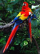 Geelvleugelara, which is indigenous to the American tropics.
 -


_(8079737929).jpg)
About 1500 bird species inhabit the Amazon Basin.[52] The biodiversity of the Amazon and the sheer number of diverse bird species is given by the number of different bird families that reside in these humid forests. An example of such would be the cotinga family, to which the Guianan cock-of-the-rock belong. Birds such as toucans, and hummingbirds are also found here. Macaws are famous for gathering by the hundreds along the clay cliffs of the Amazon River. In the western Amazon hundreds of macaws and other parrots descend to exposed river banks to consume clay on an almost daily basis,[53] the exception being rainy days.[54]
Reptielen[bewerken | brontekst bewerken]
- Anaconda, kaaimannen, matamata

The green anaconda inhabits the shallow waters of the Amazon and the emerald tree boa and boa constrictor live in the Amazonian tree tops.
Many reptiles species are illegally collected and exported for the international pet trade. Live animals are the fourth largest commodity in the smuggling industry after drugs, diamonds, and weapons.{{Citation needed|date=January 2014}}
The anaconda is found in shallow waters in the Amazon basin. One of the world's largest species of snake, the anaconda spends most of its time in the water with just its nostrils above the surface. The caiman, which is related to alligators and other crocodilians, also inhabits the Amazon as do varieties of turtles.
Amfibieën[bewerken | brontekst bewerken]
-

-
 Deforestation in the Amazon rainforest threatens many species of tree frogs, which are very sensitive to environmental changes (pictured: en:giant leaf frog)
_Edit.jpg)

- Amphibians ===
More than 1,000 species of amphibians swim and are found in the Amazon. Unlike temperate frogs which are mostly limited to habitats near water, tropical frogs are most abundant in the trees and relatively few are found near bodies of water on the forest floor. The reason for this occurrence is quite simple: frogs must always keep their skin moist since almost half of their respiration in carried out through their skin. The high humidity of the rainforest and frequent rainstorms gives tropical frogs infinitely more freedom to move into the trees and escape the many predators of rainforest waters. The differences between temperate and tropical frogs extend beyond their habitat.
Vissen[bewerken | brontekst bewerken]
-
 Characins, such as the piranha species, are prey for the giant otter, but these aggressive fish may also pose a danger to humans.
 -
 Red-bellied piranha (Pygocentrus nattereri) is a species of piranha. This species lives in the Amazon River basin, coastal rivers of northeastern Brazil, and the basins of the Paraguay, Paraná and Essequibo Rivers.

.jpg)
- Fish ===
About 2,500 fish species are known from the Amazon basin and it is estimated that more than 1,000 additional undescribed species exist.[60] This is more than any other river basin on Earth, and Amazonia is the center of diversity for Neotropical fishes.[61] About 45% (more than 1,000 species) of the known Amazonian fish species are endemic to the basin.[62] The remarkable species richness can in part be explained by the large differences between the various parts of the Amazon basin, resulting in many fish species that are endemic to small regions. For example, fauna in clearwater rivers differs from fauna in white and blackwater rivers, fauna in slow moving sections show distinct differences compared to that in rapids, fauna in small streams differ from that in major rivers, and fauna in shallow sections show distinct differences compared to that in deep parts.[63][64][65] By far the most diverse orders in the Amazon are Characiformes (43% of total fish species in the Amazon) and Siluriformes (39%), but other groups with many species include Cichlidae (6%) and Gymnotiformes (3%). The Amazon supports very large fisheries, including well-known species of large catfish (such as Brachyplatystoma, which perform long breeding migrations up the Amazon), arapaima and tambaqui, and is also home to many species that are important in the aquarium trade, such as the oscar, discus, angelfish, Corydoras catfish and neon tetra. The Amazon basin is home to the red-bellied piranha, an omnivorous forager that encompasses a larger geographic area than any other piranha species.
Some of the major fish groups of the Amazon basin include:
- Order Gymnotiformes: Neotropical electric fishes
- Order Characiformes: characins, tetras and relatives
- Family Potamotrygonidae: river stingrays
- Family Arapaimidae: bonytongues
- Family Loricariidae: suckermouth catfishes
- Family Callichthyidae: armored catfishes
- Family Pimelodidae: pimelodid catfishes
- Family Trichomycteridae: pencil catfishes
- Family Auchenipteridae: driftwood catfishes
- Subfamily Cichlinae: pike cichlids, peacock cichlids and relatives
- Subfamily Geophaginae: Eartheaters and Neotropical dwarf cichlid
- Subfamily Poeciliinae: guppies and relatives
Ongewervelden[bewerken | brontekst bewerken]
- vogelspinnen, mieren, termieten, mestkevers
-
 Mygalomorphae
 -


.jpg)
- Insects ===
More than 90% of the animal species in the Amazon are insects,{{Citation needed|reason=Reliable source needed|date=January 2014}} of which about 40% are beetles (Coleoptera constituting almost 25% of all known types of animal life-forms[66][67][68]).
Whereas all of Europe has some 321 butterfly species, the Manú National Park in Peru (4000 hectare-survey) has 1300 species, while Tambopata National Reserve (5500 hectare-survey) has at least 1231 species.
Micro-organismen[bewerken | brontekst bewerken]
Freshwater microbes are generally not very well known, even less so for a pristine ecosystem like the Amazon. Recently, metagenomics has provided answers to what kind of microbes inhabit the river.[69] The most important microbes in the Amazon River are Actinobacteria, Alphaproteobacteria, Betaproteobacteria, Gammaproteobacteria and Crenarchaeota.
Ecologie[bewerken | brontekst bewerken]
De neerslag en de

- parken en reservaten:
- Nationaal park Manú, grootste tropisch regenwoudreservaat met 850 getelde vogelsoorten[70]
- Neotropisch gebied
- Arm aan mineralen, planten vaak giftig (ara's en tapirs met hun voedingswijze als voorbeeld)
- bemesting door winden vanaf Sahara met detritus
- Verdeling in ecoregio's:
- Schimmels! (ook Cordyceps)
- planten produceren 20% van alle zuurstof[21]
- nutriënten (fosfor, kalium, kalk, onontbeerlijk voor plantengroei) weinig, 99% in levende materie, 1% in bodem, alleen bovenste 50 cm, daaronder klei[21]
- spoelen weg door regen, geleerden noemen Amazone 'natte woestijn', een van de armste bodems[21]
- meest complex ecosysteem op aarde[21]
- gemiddelde bui 25 mm / uur op bosbodem[21]
- 70 % afkomstig van verdamping bomen[21]
- bladvorm gootjes regen
- elk jaar 10 biljoen kilo sediment en modder afgevoerd van bosbodem door rivieren[21]
- diepe geulen veroorzaken elke keer andere bedding
- bomen groeien tot wel 50 m[21]
- 1% nutr. in bodem, bij gematigde bossen is dit 50%[21]
- brede wortels, vallen snel om[21]
- in één boom 2000 soorten insecten en spinnen gevonden, waarvan 100 bekend waren[21]
- in jonge bladeren minste gif[21]
- spijsvertering witgezichtsaki kan vrijwel alle plantengiften aan[21]
- samenwerking mier en plant (myrmecotrofie)
- schimmels nemen voedingsstoffen tot zich voor de regen ze wegspoelt[21]
Sahara Desert dust windblown to the Amazon[bewerken | brontekst bewerken]
More than 56% of the dust fertilizing the Amazon rainforest comes from the Bodélé depression in Northern Chad in the Sahara desert. The dust contains phosphorus, important for plant growth. The yearly Sahara dust replaces the equivalent amount of phosphorus washed away yearly in Amazon soil from rains and floods.[71] Up to 50 million tonnes of Sahara dust per year are blown across the Atlantic Ocean.[72][73] NASA Video.
NASA's CALIPSO satellite has measured the amount of dust transported by wind from the Sahara to the Amazon: an average 182 million tons of dust are windblown out of the Sahara each year, at 15 degrees west longitude, across 1,600 miles (2,600 over the Atlantic Ocean (some dust falls into the Atlantic), then at 35 degrees West longitude at the eastern coast of South America, 27.7 million tons (15%) of dust fall over the Amazon basin, 132 million tons of dust remain in the air, 43 million tons of dust are windblown and falls on the Caribbean Sea, past 75 degrees west longitude.[74]
CALIPSO uses a laser range finder to scan the Earth's atmosphere for the vertical distribution of dust and other aerosols. CALIPSO regularly tracks the Sahara-Amazon dust plume. CALIPSO has measured variations in the dust amounts transported— an 86 percent drop between the highest amount of dust transported in 2007 and the lowest in 2011.
A possibility causing the variation is the Sahel, a strip of semi-arid land on the southern border of the Sahara. When rain amounts in the Sahel are higher, the volume of dust is lower. The higher rainfall could make more vegetation grow in the Sahel, leaving less sand exposed to winds to blow away.[75]
- Schade aan het leefmilieu en het voorkomen hiervan ===
Het Amazoneregenwoud wordt de laatste decennia ernstig beschadigd. Vooral ontbossing is een groot probleem. Uit de vernietiging van het bos zal verlies van biodiversiteit voortvloeien. Verder van belang is de hoeveelheid koolstof die in de bomen zit: het vrijkomen van deze koolstof zal het broeikaseffect versterken. Er ligt ook een economische drijfveer achter het beschermen van het regenwoud: één vierkante kilometer Peruaans Amazoneregenwoud is naar schatting $ 692.000 waard als het woud intact en duurzaam is. Er zouden veel lucratieve gewassen en bomen op verbouwd kunnen worden, zoals vruchten, latex en hout.
- Ontbossing ===
Meer dan één vijfde van het Amazoneregenwoud reeds is ontbost. Ook wordt er nog een groot deel bedreigd, met name vanwege (veelal illegale) houtkap en (aangestoken) bosbranden.Er zijn belangengroepen (ranchers, sojaboeren bv.) die illegaal land nemen, het bos rooien en in gebruik nemen voor eigen baat. Wie deze praktijken aan de kaak stelt en het op durft te nemen voor de rechten van eigenaren : inheemse stammen of kleine boeren werd en wordt bedreigd of zelfs vermoord (B.v. Chico Mendes, Zuster Dorothy Stang e.v.a.) De rook van deze bosbranden houdt de neerslag tegen en verergert de droogte. De boswetgeving, die voorziet dat 80% van het woud behouden moet blijven in elke zone waar gronden van bestemming veranderen, wordt overtreden.
- Vervuiling ===
Veel ondernemingen die zich in het Amazoneregenwoud vestigen, zoals de olie-industrie en plantages, springen nogal onzorgvuldig om met de omgeving. De oliepijpleidingen lekken zo veel dat de zandweggetjes er pikzwart uitzien, de olie sijpelt ook door in het drinkwater van de plaatselijke bevolking.
De plantages gebruiken grote hoeveelheden meststoffen en pesticiden. Ook is afval een groot probleem, op sommige plaatsen is er meer dan 4.000 ton van enkel pesticidenverpakkingen.
- Mogelijke oplossingen ===
Een manier om ervoor te zorgen dat de boeren genoeg winst maken zodat ze hun grond niet hoeven te verkopen aan grootgrondbezitters door de nood aan meststoffen teniet te doen, zou zijn door gebruik te maken van de terra preta, zeer vruchtbare grond in het Amazoneregenwoud die is nagelaten door een lang vergeten beschaving waar tegenwoordig nog enkele indianenstammen van overleven. Deze aarde kan men zelf maken door in de plaats van de as van de afgebrande bomen door de regen te laten wegspoelen, het vuur op tijd uit te doven zodat er houtskool van overblijft, gemengd met de grond wordt die zeer vruchtbaar. Om het oude ecosysteem enigszins in ere te houden zou gebruik kunnen worden gemaakt van agro-bosbouw, waarin verscheidene planten worden geteeld in een op de oorspronkelijke gelijkende omgeving. Maar het beste zou zijn dat alle mensen die schade berokkenen aan de natuur weggaan uit het Amazone-woud. Daar is echter onvoldoende (politieke) steun voor.
- Deforestation ==
_12ago2007.jpg)
Deforestation is the conversion of forested areas to non-forested areas. The main sources of deforestation in the Amazon are human settlement and development of the land.[76] Prior to the early 1960s, access to the forest's interior was highly restricted, and the forest remained basically intact.[77] Farms established during the 1960s were based on crop cultivation and the slash and burn method. However, the colonists were unable to manage their fields and the crops because of the loss of soil fertility and weed invasion.[78] The soils in the Amazon are productive for just a short period of time, so farmers are constantly moving to new areas and clearing more land. These farming practices led to deforestation and caused extensive environmental damage.[79] Deforestation is considerable, and areas cleared of forest are visible to the naked eye from outer space.
In the 1970s construction began on the Trans-Amazonian highway. This highway represented a major threat to the Amazon rainforest.[80] Fortunately for the rainforest, the highway has not been completed, hereby reducing the environmental damage.
Between 1991 and 2000, the total area of forest lost in the Amazon rose from 415,000 to 587,000 square kilometres (160,000 to 227,000, with most of the lost forest becoming pasture for cattle.[81] Seventy percent of formerly forested land in the Amazon, and 91% of land deforested since 1970, is used for livestock pasture.[82][83] Currently, Brazil is the second-largest global producer of soybeans after the United States. New research however, conducted by Leydimere Oliveira et al., has shown that the more rainforest is logged in the Amazon, the less precipitation reaches the area and so the lower the yield per hectare becomes. So despite the popular perception, there has been no economical advantage for Brazil from logging rainforest zones and converting these to pastoral fields.[84]
The needs of soy farmers have been used to justify many of the controversial transportation projects that are currently developing in the Amazon. The first two highways successfully opened up the rainforest and led to increased settlement and deforestation. The mean annual deforestation rate from 2000 to 2005 (22,392 per year) was 18% higher than in the previous five years (19,018 per year).[85] Although deforestation has declined significantly in the Brazilian Amazon between 2004 and 2014, there has been an increase to the present day.[86]-
 NASA satellite observation of deforestation in the Mato Grosso state of Brazil. The transformation from forest to farm is evident by the paler square shaped areas under development.
 -
 Fires and deforestation in the state of Rondônia.
 -
 One consequence of forest clearing in the Amazon: thick smoke that hangs over the forest.


- Conservation and climate change ==
.jpg)
Environmentalists are concerned about loss of biodiversity that will result from destruction of the forest, and also about the release of the carbon contained within the vegetation, which could accelerate global warming. Amazonian evergreen forests account for about 10% of the world's terrestrial primary productivity and 10% of the carbon stores in ecosystems[87]—of the order of 1.1 × 10¹¹ metric tonnes of carbon.[88] Amazonian forests are estimated to have accumulated 0.62 ± 0.37 tons of carbon per hectare per year between 1975 and 1996.
One computer model of future climate change caused by greenhouse gas emissions shows that the Amazon rainforest could become unsustainable under conditions of severely reduced rainfall and increased temperatures, leading to an almost complete loss of rainforest cover in the basin by 2100.[89][90] However, simulations of Amazon basin climate change across many different models are not consistent in their estimation of any rainfall response, ranging from weak increases to strong decreases.[91] The result indicates that the rainforest could be threatened though the 21st century by climate change in addition to deforestation.
In 1989, environmentalist C.M. Peters and two colleagues stated there is economic as well as biological incentive to protecting the rainforest. One hectare in the Peruvian Amazon has been calculated to have a value of $6820 if intact forest is sustainably harvested for fruits, latex, and timber; $1000 if clear-cut for commercial timber (not sustainably harvested); or $148 if used as cattle pasture.[92]
As indigenous territories continue to be destroyed by deforestation and ecocide, such as in the Peruvian Amazon[93] indigenous peoples' rainforest communities continue to disappear, while others, like the Urarina continue to struggle to fight for their cultural survival and the fate of their forested territories. Meanwhile, the relationship between non-human primates in the subsistence and symbolism of indigenous lowland South American peoples has gained increased attention, as have ethno-biology and community-based conservation efforts.
From 2002 to 2006, the conserved land in the Amazon rainforest has almost tripled and deforestation rates have dropped up to 60%. About 1,000,000 square kilometres (250,000,000 acres) have been put onto some sort of conservation, which adds up to a current amount of 1,730,000 square kilometres (430,000,000 acres).[94]-
 Anthropogenic emission of greenhouse gases broken down by sector for the year 2000.
 -
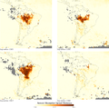 Aerosols over the Amazon each September for four burning seasons (2005 through 2008). The aerosol scale (yellow to dark reddish-brown) indicates the relative amount of particles that absorb sunlight.
 -
 Aerial roots of red mangrove on an Amazonian river.


Remote sensing[bewerken | brontekst bewerken]

The use of remotely sensed data is dramatically improving conservationists' knowledge of the Amazon basin. Given the objectivity and lowered costs of satellite-based land cover analysis, it appears likely that remote sensing technology will be an integral part of assessing the extent and damage of deforestation in the basin.[96] Furthermore, remote sensing is the best and perhaps only possible way to study the Amazon on a large-scale.[97]
The use of remote sensing for the conservation of the Amazon is also being used by the indigenous tribes of the basin to protect their tribal lands from commercial interests. Using handheld GPS devices and programs like Google Earth, members of the Trio Tribe, who live in the rainforests of southern Suriname, map out their ancestral lands to help strengthen their territorial claims.[98] Currently, most tribes in the Amazon do not have clearly defined boundaries, making it easier for commercial ventures to target their territories.
To accurately map the Amazon's biomass and subsequent carbon related emissions, the classification of tree growth stages within different parts of the forest is crucial. In 2006 Tatiana Kuplich organized the trees of the Amazon into four categories: (1) mature forest, (2) regenerating forest [less than three years], (3) regenerating forest [between three and five years of regrowth], and (4) regenerating forest [eleven to eighteen years of continued development].[99] The researcher used a combination of Synthetic aperture radar (SAR) and Thematic Mapper (TM) to accurately place the different portions of the Amazon into one of the four classifications.
Impact of early 21st-century Amazon droughts[bewerken | brontekst bewerken]
In 2005, parts of the Amazon basin experienced the worst drought in one hundred years,[100] and there were indications that 2006 could have been a second successive year of drought.[101] A July 23, 2006 article in the UK newspaper The Independent reported Woods Hole Research Center results showing that the forest in its present form could survive only three years of drought.[102][103] Scientists at the Brazilian National Institute of Amazonian Research argue in the article that this drought response, coupled with the effects of deforestation on regional climate, are pushing the rainforest towards a "tipping point" where it would irreversibly start to die. It concludes that the forest is on the brink of being turned into savanna or desert, with catastrophic consequences for the world's climate.
According to the World Wide Fund for Nature, the combination of climate change and deforestation increases the drying effect of dead trees that fuels forest fires.[104]
In 2010 the Amazon rainforest experienced another severe drought, in some ways more extreme than the 2005 drought. The affected region was approximate 1,160,000 square miles (3,000,000 of rainforest, compared to 734,000 square miles (1,900,000 in 2005. The 2010 drought had three epicenters where vegetation died off, whereas in 2005 the drought was focused on the southwestern part. The findings were published in the journal Science. In a typical year the Amazon absorbs 1.5 gigatons of carbon dioxide; during 2005 instead 5 gigatons were released and in 2010 8 gigatons were released.[105][106]
In populaire cultuur[bewerken | brontekst bewerken]
Mysterieus gebied waar tot de verbeelding sprekende wezens leven: Creature from the Black Lagoon (1954), Anaconda (1997),
NotenBronnen
|
|deadurl=no}}</ref> However, the rainforest still managed to thrive during these glacial periods, allowing for the survival and evolution of a broad diversity of species.[1]
During the mid-Eocene, it is believed that the drainage basin of the Amazon was split along the middle of the continent by the Purus Arch. Water on the eastern side flowed toward the Atlantic, while to the west water flowed toward the Pacific across the Amazonas Basin. As the Andes Mountains rose, however, a large basin was created that enclosed a lake; now known as the Solimões Basin. Within the last 5–10 million years, this accumulating water broke through the Purus Arch, joining the easterly flow toward the Atlantic.[2][3]
There is evidence that there have been significant changes in Amazon rainforest vegetation over the last 21,000 years through the Last Glacial Maximum (LGM) and subsequent deglaciation. Analyses of sediment deposits from Amazon basin paleolakes and from the Amazon Fan indicate that rainfall in the basin during the LGM was lower than for the present, and this was almost certainly associated with reduced moist tropical vegetation cover in the basin.[4] There is debate, however, over how extensive this reduction was. Some scientists argue that the rainforest was reduced to small, isolated refugia separated by open forest and grassland;[5] other scientists argue that the rainforest remained largely intact but extended less far to the north, south, and east than is seen today.[6] This debate has proved difficult to resolve because the practical limitations of working in the rainforest mean that data sampling is biased away from the center of the Amazon basin, and both explanations are reasonably well supported by the available data.
Human activity[bewerken | brontekst bewerken]

Based on archaeological evidence from an excavation at Caverna da Pedra Pintada, human inhabitants first settled in the Amazon region at least 11,200 years ago.[7] Subsequent development led to late-prehistoric settlements along the periphery of the forest by AD 1250, which induced alterations in the forest cover.[8]

For a long time, it was thought that the Amazon rainforest was only ever sparsely populated, as it was impossible to sustain a large population through agriculture given the poor soil. Archeologist Betty Meggers was a prominent proponent of this idea, as described in her book Amazonia: Man and Culture in a Counterfeit Paradise. She claimed that a population density of 0.2 inhabitants per square kilometre (0.52/sq is the maximum that can be sustained in the rainforest through hunting, with agriculture needed to host a larger population.[9] However, recent anthropological findings have suggested that the region was actually densely populated. Some 5 million people may have lived in the Amazon region in AD 1500, divided between dense coastal settlements, such as that at Marajó, and inland dwellers.[10] By 1900 the population had fallen to 1 million and by the early 1980s it was less than 200,000.
The first European to travel the length of the Amazon River was Francisco de Orellana in 1542.[11] The BBC's Unnatural Histories presents evidence that Orellana, rather than exaggerating his claims as previously thought, was correct in his observations that a complex civilization was flourishing along the Amazon in the 1540s. It is believed that the civilization was later devastated by the spread of diseases from Europe, such as smallpox.
- Etymology ==
The name Amazon is said to arise from a war Francisco de Orellana fought with the Tapuyas and other tribes. The women of the tribe fought alongside the men, as was their custom.[12] Orellana derived the name Amazonas from the Amazons of Greek mythology, described by Herodotus and Diodorus.
Since the 1970s, numerous geoglyphs have been discovered on deforested land dating between AD 1–1250, furthering claims about Pre-Columbian civilizations.[13][14] Ondemar Dias is accredited with first discovering the geoglyphs in 1977 and Alceu Ranzi with furthering their discovery after flying over Acre.[15][16] The BBC's Unnatural Histories presented evidence that the Amazon rainforest, rather than being a pristine wilderness, has been shaped by man for at least 11,000 years through practices such as forest gardening and terra preta. Terra preta is found over large areas in the Amazon forest; and is now widely accepted as a product of indigenous soil management. The development of this fertile soil allowed agriculture and silviculture in the previously hostile environment; meaning that large portions of the Amazon rainforest are probably the result of centuries of human management, rather than naturally occurring as has previously been supposed.[17] In the region of the Xingu tribe, remains of some of these large settlements in the middle of the Amazon forest were found in 2003 by Michael Heckenberger and colleagues of the University of Florida. Among those were evidence of roads, bridges and large plazas.[18]
en:Amazon River[bewerken | brontekst bewerken]
| Heinonlein/Koelkast/Vriezer | ||||
|---|---|---|---|---|

| ||||
| Lengte | ~6530[19] km | |||
| Hoogte (bron) | 5200 m | |||
| Debiet | 204 000 m³/s | |||
| Stroomgebied | 6.915.000 km² | |||
| Bron | Andes, Peru | |||
| Monding | Atlantische oceaan | |||
| Stroomt door | Peru - Brazilië - Bolivia - Colombia - Ecuador | |||
|
| ||||
|
| ||||
De oorsprong van de Amazone op de berg Nevado Mismi in de Andes, gemarkeerd door een houten kruis.
| ||||
| ||||
De Amazone is een grote rivier in Zuid-Amerika. Het is de langste of op de Nijl na langste rivier van de wereld (dit hangt ervan af welke lengte men aan de Amazone toekent; hierover is men het oneens), en veruit de waterrijkste, met een debiet van vijf keer dat van de tweede in rang, de Congo. De rivier heeft een totale lengte van ongeveer 6530 km[19] of 6448 km, ontspringt in Peru en mondt in Brazilië uit in de Atlantische Oceaan. De Amazone stroomt door het Amazoneregenwoud. Tijdens de regentijd is de rivier op sommige plaatsen tot wel veertig kilometer breed.
De vorming van het Andesgebergte, 23 miljoen jaar geleden, had een wijziging in de afwatering van het gebied tot gevolg die aan de basis van het ontstaan van de Amazone ligt.[20] Voor het ontstaan van de Andes waterde het gebied deels af in wat nu de Grote Oceaan heet.
Discussie over de lengte[bewerken | brontekst bewerken]
De meerderheid van de gezaghebbende geografische instanties beschouwt de Amazone als de op één na langste rivier ter wereld. Als langste rivier geldt de Nijl in Afrika. Verschillende geografen hebben voor de Nijl een lengte tussen 5499 en 6695 kilometer vastgesteld. De verschillen tussen de diverse metingen zijn dikwijls het resultaat van verschillende definities.
De lengte van de Amazone is vastgesteld op 6259 tot 6800 kilometer. Deze laatste lengte is de conclusie van een expeditie uit 2007, die de bron van de Amazone in het zuiden van Peru en niet in het noorden gevonden zegt te hebben.[21][22] Dit resultaat moet echter nog door andere geografen bevestigd worden. Indien de Amazone daadwerkelijk 6800 kilometer lang is, is hij langer dan de Nijl.
Naam[bewerken | brontekst bewerken]
Toen de conquistador Francisco de Orellana in 1541 met enkele honderden manschappen de rivier afvoer die later Amazone genoemd zou worden, dacht hij op een bepaald moment dat de krijgers, die hem en zijn manschappen met vergiftigde pijlen bestookten, vrouwen waren. In het reisverslag werden zij "Amazonen" genoemd, en vervolgens werd de rivier hiernaar vernoemd.
Geschiedenis[bewerken | brontekst bewerken]
Precolonial civilization[bewerken | brontekst bewerken]
During what many archaeologists call the formative period, Amazonian societies were deeply involved in the emergence of South America's highland agrarian systems. This possibly contributed to the social and religious institutions essential to the order of Andean civilization.
Early human settlements were typically based on low-lying hills or mounds.Shell mounds were the earliest; they represent piles of human refuse and are mainly dated between 7500 and 4000 BP. They all represent pottery age cultures; no preceramic shell mounds have been documented so far by archaeologists.Five types of archaeological mound have been noted in the Amazon region: shell refuse and artificial mounds, artificial earth platforms for entire villages, earth mounds and ridges for cultivation, causeways and canals, and figurative mounds, both geometric and biomorphic.[23]
_(1450150520).jpg)
Artificial earth platforms for entire villages are the second type of mounds. They are best represented by the Marajoara culture.
Figurative mounds are the latest, chronologically.
There is ample evidence that the areas surrounding the Amazon River were home to complex and large-scale indigenous societies, mainly chiefdoms who developed large towns and cities. Archeologists estimate that by the time the Spanish conquistador Orellana journeyed across the Amazon in 1541, more than 3 million Natives lived around the Amazon.[24] These pre-Columbian settlements created highly developed civilizations. For instance, pre-Columbian indigenous people on the island of Marajó may have developed social stratification and supported a population of 100,000 people. In order to achieve this level of development, the Native Americans of the Amazon rain forest altered the forest’s ecology by selective cultivation and the use of fire. Scientists argue that by burning areas of the forest repetitiously, the indigenous people caused the soil to become rich in nutrients. This created dark soil areas known as terra preta de índio (Indian Dark Earth).[25] Because of the terra preta, indigenous communities were able to make land fertile and thus sustainable for the large-scale agriculture needed to support their large populations and complex social structures. Further research has hypothesized that this practice began around 11,000 years ago. Some say that its effects on forest ecology and regional climate explain the otherwise inexplicable band of lower rainfall through the Amazon basin.[26]
Many indigenous tribes engaged in constant warfare. James Stuart Olson wrote: "The Munduruku expansion dislocated and displaced the Kawahíb, breaking the tribe down into much smaller groups ... [Munduruku] first came to the attention of Europeans in 1770 when they began a series of widespread attacks on Brazilian settlements along the Amazon River."[27]
European discovery[bewerken | brontekst bewerken]
.jpg)
In March 1500 Spanish conquistador Vicente Yáñez Pinzón was the first documented European to sail into the river.[28] Pinzón called the river flow Río Santa María del Mar Dulce, later shortened to Mar Dulce (literally, sweet sea, because of its fresh water pushing out into the ocean). Another Spanish explorer, Francisco de Orellana, was the first European man to travel from the founts situated in the Andes to the end of the river. In this travel, Orellana baptized some of the affluents of the amazonas like Rio Negro, Napo or Jurua. The name Amazonas came from the native warriors that attacked this expedition, mostly women, that reminded Orellana of the woman warriors the Amazons from Hellenic (ancient Greek) culture .
Exploration[bewerken | brontekst bewerken]
Gonzalo Pizarro set off in 1541 to explore east of Quito into the South American interior in search of El Dorado, the "city of gold" and La Canela, the "valley of cinnamon".[29] He was accompanied by his second-in-command Francisco de Orellana. After 170 km, the Coca River joined the Napo River (at a point now known as Puerto Francisco de Orellana); the party stopped for a few weeks to build a boat just upriver from this confluence. They continued downriver through an uninhabited area, where they could not find food. Orellana offered and was ordered to follow the Napo River, then known as Río de la Canela ("Cinnamon River") and return with food for the party. Based on intelligence received from a captive native chief named Delicola, they expected to find food within a few days downriver by ascending another river to the north.

Orellana took about 57 men, the boat, and some canoes and left Pizarro's party on 26 December 1541. However, Orellana apparently missed the confluence (probably with the Aguarico) where he was to look for food. By the time he and his men reached another village many of them were sick from hunger and eating "noxious plants", and near death. Seven men died at that village. His men threatened to mutiny if he followed his orders and the expedition turned back to join Pizarro's larger party. He accepted to change the purpose of the expedition to discover new lands in the name of the King of Spain, and the men built a larger boat in which to navigate downstream. After a journey of 600 km down the Napo River they reached a further major confluence, at a point near modern Iquitos, and then followed the upper Amazon, now known as the Solimões, for a further 1,200 km to its confluence with the Rio Negro (near modern Manaus), which they reached on 3 June 1542. On the Nhamunda River, a tributary of the Amazon downstream from Manaus, Orellana's party had a fierce battle with warriors who, they reported, were led by fierce female warriors who beat the men to death with clubs if they tried to retreat.{{Citation needed|date=November 2012}} Orellana's men began referring to the women as Amazons, a reference to the women of Greek Mythology. The river was initially known as the Marañón (the name by which the Peruvian part of the river is still known today) or Rio de Orellana. It later became known as the Rio Amazonas, the name by which it is still known in both Spanish and Portuguese.
Regarding the initial mission of finding cinnamon, Pizarro reported to the King that they had found cinnamon trees, but that they could not be profitably harvested. In fact, true cinnamon (Cinnamomum verum) is not native to South America. Other related cinnamon-containing plants (of the family Lauraceae) are fairly common in that part of the Amazon and Pizarro probably saw some of these. The expedition reached the mouth of the Amazon on 24 August 1542, demonstrating the practical navigability of the Great River.

In 1560 another Spanish conquistador, Lope de Aguirre, may have made the second descent of the Amazon. Historians are uncertain whether the river he descended was the Amazon or the Orinoco River, which runs more or less parallel to the Amazon further north.
Portuguese explorer Pedro Teixeira was the first European to travel up the entire river. He arrived in Quito in 1637, and then returned via the same route.[30]
From 1648 to 1652 Portuguese Brazilian bandeirante António Raposo Tavares led an expedition from São Paulo overland to the mouth of the Amazon, investigating many of its tributaries, including the Rio Negro, and covering a distance of more than 10,000.
In what is currently Brazil, Ecuador, Bolivia, Colombia, Peru, and Venezuela, a number of colonial and religious settlements were established along the banks of primary rivers and tributaries for the purpose of trade, slaving and evangelization among the indigenous peoples of the vast rainforest, such as the Urarina. In the late 1600s Spanish Jesuit Father Samuel Fritz, apostle of the Omaguas, established some forty mission villages.
Scientific exploration[bewerken | brontekst bewerken]

Early scientific, zoological and botanical exploration of the Amazon River and basin occurred in the second half of 18th century through the first half of the 19th century.
- Charles Marie de La Condamine explored the river in 1743.[31]
- Alexander von Humboldt, 1799–1804
- Johann Baptist von Spix and Carl Friedrich Philipp von Martius, 1817–1820
- Henry Walter Bates and Alfred Russel Wallace, 1848–1859
Post-colonial exploitation and settlement[bewerken | brontekst bewerken]
The Cabanagem revolt (1835–1840) was directed against the white ruling class. It is estimated that from 30 to 40% of the population of Grão-Pará, estimated at 100,000 people, died.[32]
The total population of the Brazilian portion of the Amazon basin in 1850 was perhaps 300,000, of whom about two-thirds were Europeans and slaves, the slaves amounting to about 25,000. The Brazilian Amazon's principal commercial city, Pará (now Belém), had from 10,000 to 12,000 inhabitants, including slaves. The town of Manáos, now Manaus, at the mouth of the Rio Negro, had a population between 1,000 and 1,500. All the remaining villages, as far up as Tabatinga, on the Brazilian frontier of Peru, were relatively small.
On 6 September 1850 Emperor Pedro II of Brazil sanctioned a law authorizing steam navigation on the Amazon and gave the Viscount of Mauá (Irineu Evangelista de Sousa) the task of putting it into effect. He organized the "Companhia de Navegação e Comércio do Amazonas" in Rio de Janeiro in 1852; in the following year it commenced operations with four small steamers, the Monarca ('Monarch'), the Cametá, the Marajó and the Rio Negro.[33]

At first, navigation was principally confined to the main river; and even in 1857 a modification of the government contract only obliged the company to a monthly service between Pará and Manaus, with steamers of 200 tons cargo capacity, a second line to make six round voyages a year between Manaus and Tabatinga, and a third, two trips a month between Pará and Cametá. This was the first step in opening up the vast interior.
The success of the venture called attention to the opportunities for economic exploitation of the Amazon, and a second company soon opened commerce on the Madeira, Purús and Negro; a third established a line between Pará and Manaus; and a fourth found it profitable to navigate some of the smaller streams. In that same period, the Amazonas Company was increasing its fleet. Meanwhile, private individuals were building and running small steam craft of their own on the main river as well as on many of its tributaries.
On 31 July 1867 the government of Brazil, constantly pressed by the maritime powers and by the countries encircling the upper Amazon basin, especially Peru, decreed the opening of the Amazon to all countries, but they limited this to certain defined points: Tabatinga – on the Amazon; Cametá – on the Tocantins; Santarém – on the Tapajós; Borba – on the Madeira, and Manaus – on the Rio Negro. The Brazilian decree took effect on 7 September 1867.

Thanks in part to the mercantile development associated with steamboat navigation coupled with the internationally driven demand for natural rubber, the Peruvian city of Iquitos became a thriving, cosmopolitan center of commerce. Foreign companies settled in Iquitos, from whence they controlled the extraction of rubber. In 1851 Iquitos had a population of 200, and by 1900 its population reached 20,000. In the 1860s, approximately 3,000 tons of rubber was being exported annually, and by 1911 annual exports had grown to 44,000 tons, representing 9.3% of Peru's exports.[34] During the rubber boom it is estimated that diseases brought by immigrants, such as typhus and malaria, killed 40,000 native Amazonians.[35]
The first direct foreign trade with Manaus commenced around 1874. Local trade along the river was carried on by the English successors to the Amazonas Company—the Amazon Steam Navigation Company—as well as numerous small steamboats, belonging to companies and firms engaged in the rubber trade, navigating the Negro, Madeira, Purús and many other tributaries, such as the Marañón, to ports as distant as Nauta, Peru.
By the turn of the 20th century, the exports of the Amazon basin were India-rubber, cacao beans, Brazil nuts and a few other products of minor importance, such as pelts and exotic forest produce (resins, barks, woven hammocks, prized bird feathers, live animals) and extracted goods, such as lumber and gold.
20th-century development[bewerken | brontekst bewerken]

Since colonial times, the Portuguese portion of the Amazon basin has remained a land largely undeveloped by agriculture and occupied by indigenous people who survived the arrival of European diseases.
Four centuries after the European discovery of the Amazon river, the total cultivated area in its basin was probably less than 65 square kilometres (25, excluding the limited and crudely cultivated areas among the mountains at its extreme headwaters. This situation changed dramatically during the 20th century.
Wary of foreign exploitation of the nation's resources, Brazilian governments in the 1940s set out to develop the interior, away from the seaboard where foreigners owned large tracts of land. The original architect of this expansion was President Getúlio Vargas, with the demand for rubber from the Allied forces in World War II providing funding for the drive.
In 1960 the construction of the new capital city of Brasília in the interior also contributed to the opening up of the Amazon basin. A large-scale colonization program saw families from northeastern Brazil relocated to the forests, encouraged by promises of cheap land. Many settlements grew along the road from Brasília to Belém, but rainforest soil proved difficult to cultivate.
Still, long-term development plans continued. Roads were cut through the forests, and in 1970, the work on the Trans-Amazonian Highway (Transamazônica) network began. The network's three pioneering highways were completed within ten years but never fulfilled their promise. Large portions of the Trans-Amazonian and its accessory roads, such as BR-319 (Manaus-Porto Velho), are derelict and impassable in the rainy season. Small towns and villages are scattered across the forest, and because its vegetation is so dense, some remote areas are still unexplored.
With a population of 1.9 million people in 2014, Manaus is the largest city on the Amazon. Manaus alone makes up approximately 50% of the population of the largest Brazilian state of Amazonas. The racial makeup of the city is 64% Pardo (Mulatto and mestizo) and 32% White.[36]
Although the Amazon river remains largely undammed, around 412 dams are in operation in the Amazon’s tributary rivers. From these 412 dams, 151 are constructed over six of the main tributary rivers that drain into the Amazon.[37] Since only four percent of the Amazon’s hydropower potential has been developed in countries like Brazil,[38] more damming projects are underway and hundreds more are planned.[39] After witnessing the negative effects of environmental degradation, sedimentation, navigation and flood control caused by the Three Gorges Dam in the Yangtze River,[40] scientists are worried that constructing more dams in the Amazon will harm its biodiversity in the same way by “blocking-fish spawning runs, reducing the flows of vital oil nutrients and clearing forests”. Damming the Amazon River could potentially bring about the “end of free flowing rivers” and contribute to an “ecosystem collapse” that will cause major social problems
External links[bewerken | brontekst bewerken]
- Bibliography on Water Resources and International Law Peace Palace Library
- Information on the Amazon from Extreme Science
- A photographic journey up the Amazon River from its mouth to its source
- Amazon Alive: Light & Shadow documentary film about the Amazon river
- Amazon River Ecosystem
- Research on the influence of the Amazon River on the Atlantic Ocean at the University of Southern California
en:Amazon basin[bewerken | brontekst bewerken]

Het Amazonebekken, ook wel het Amazonegebied, het Braziliaans laagland of het Laagland van de Amazone genoemd, is het drainagebekken van de Amazone en haar zijrivieren. Het is een uitgestrekt laagland in het noorden van Zuid-Amerika. Het gebied ligt grotendeels in het noorden van Brazilië, maar voor een deel ook in Venezuela, Colombia, Peru, Bolivia, Guyana en Suriname. Het totale oppervlakte is zo'n 4,5 miljoen vierkante kilometer.
Economie en de indianen[bewerken | brontekst bewerken]
Vanwege de aanwezigheid van goud, uranium, ijzererts en diamant zijn veel bomen gekapt om ruimte te maken voor mijnbouw, landingsbanen en wegen. Het tropisch hardhout levert veel geld op. Veel Brazilianen zijn naar het regenwoud getrokken om akkers aan te leggen of een veeteeltbedrijf te beginnen. Met oorspronkelijke bewoners, de indianen, werd geen rekening gehouden. Door de ontbossing is meer dan één vijfde van het Amazoneregenwoud reeds verdwenen. Er zijn organisaties die het regenwoud in stand proberen te houden door diploma's te geven aan bedrijven die goed voor het regenwoud zorgen en de indianen te leren hoe ze meer geld kunnen verdienen met het hout dat ze kappen.
Externe links[bewerken | brontekst bewerken]
Lokale bevolking[bewerken | brontekst bewerken]

Amazonia is sparsely populated. There are scattered settlements inland, but most of the population lives in a few larger cities on the banks of the Amazon and other major rivers, such as in Iquitos, Peru, and Manaus and Belém (Brazil). In many regions, the forest has been cleared for soya bean plantations and ranching (the most extensive non-forest use of the land); some of the inhabitants harvest wild rubber latex, and Brazil nuts. This is a form of extractive farms, where the trees are not cut down. These are relatively sustainable operations in contrast to lumbering or agriculture dependent on clearing the rainforest.
The largest organization fighting for the indigenous peoples in this area is COICA. It is a supra organization encompassing all indigenous rights organizations working in the Amazon basin area, and covers the people living in several countries.
River commerce[bewerken | brontekst bewerken]
The river is the principal path of transportation for people and produce in the regions, with transport ranging from balsa rafts and dugout canoes to hand built wooden river craft and modern steel hulled craft.
Agriculture[bewerken | brontekst bewerken]
Seasonal floods excavate and redistribute nutrient-rich silt onto beaches and islands, enabling dry-season riverside agriculture of rice, beans, and corn on the river's shoreline without the addition of fertilizer, with additional slash and burn agriculture on higher floodplains. Fishing provides additional food year round, and free-range chickens need little or no food beyond what they can forage locally. Charcoal made largely from forest and shoreline deadfall is produced for use in urban areas. Exploitation of bush meat, particularly deer and turtles is common.

Extensive deforestation, particularly in Brazil, is leading to the extinction of known and unknown species, reducing biological diversity and adversely impacting soil, water, and air quality. A final part of the deforestation process is the large-scale production of charcoal for industrial processes such as steel manufacturing. Soils within the region are generally shallow and cannot be used for more than a few seasons without the addition of imported fertilizers and chemicals.
Languages[bewerken | brontekst bewerken]
The most widely spoken language in the Amazon is Portuguese, followed closely by Spanish. On the Brazilian side Portuguese is spoken by at least 98% of the population, whilst in the Spanish-speaking countries a large number of speakers of indigenous languages are present, though Spanish is predominant.
There are hundreds of native languages still spoken in the Amazon, most of which are spoken by only a handful of people, and thus are critically endangered. One of the more widely spoken indigenous languages in the Amazon is Nheengatu, which descends from the ancient Tupi language, originally spoken in the coastal and central regions of Brazil. It was brought to its present location along the Rio Negro by Brazilian colonizers who, until the mid-17th century, primarily used Tupi rather than the official Portuguese to communicate. Besides modern Nheengatu, other languages of the Tupi family are spoken there, along with other language families like Jê, Arawak, Karib, Arawá, Yanomamo, Matsés and others.
- ↑ Malhi, Yadvinder (2005), Tropical Forests & Global Atmospheric Change. Oxford University Press. ISBN 0-19-856706-5.
- ↑ Costa, João Batista Sena, Bemerguy, Ruth Léa, Hasui, Yociteru (2001). Tectonics and paleogeography along the Amazon river. Journal of South American Earth Sciences 14 (4): 335–347. DOI: 10.1016/S0895-9811(01)00025-6.
- ↑ Milani, Edison José, Zalán, Pedro Victor (1999). An outline of the geology and petroleum systems of the Paleozoic interior basins of South America (PDF). Episodes 22 (3): 199–205. Gearchiveerd van origineel op October 1, 2008. Geraadpleegd op 25 september 2008.
- ↑ Colinvaux, P.A., De Oliveira, P.E. 2000.
- ↑ Van der Hammen, T., Hooghiemstra, H.. 2002.
- ↑ Colinvaux, P. A., De Oliveira, P. E., Bush, M. B. (January 2000). Amazonian and neotropical plant communities on glacial time-scales: The failure of the aridity and refuge hypotheses. Quaternary Science Reviews 19 (1–5): 141–169. DOI: 10.1016/S0277-3791(99)00059-1.
- ↑ Roosevelt, A. C., da Costa, M. Lima, Machado, C. Lopes, Michab, M., Mercier, N. (19 april 1996). Paleoindian Cave Dwellers in the Amazon: The Peopling of the Americas. Science 272 (5260): 373–384. DOI: 10.1126/science.272.5260.373.
- ↑ Heckenberger, Michael J., Kuikuro, Afukaka, Kuikuro, Urissapá Tabata (19 september 2003). Amazonia 1492: Pristine Forest or Cultural Parkland?. Science 301 (5640): 1710–1714. PMID 14500979. DOI: 10.1126/science.1086112.
- ↑ Meggers, Betty J. (19 december 2003). Revisiting Amazonia Circa 1492. Science 302 (5653): 2067–2070. PMID 14684803. DOI: 10.1126/science.302.5653.2067b.
- ↑ Chris C. Park (2003), Tropical Rainforests. Routledge, p. 108.
- ↑ Smith, A (1994), Explorers of the Amazon. University of Chicago Press, Chicago. ISBN 0-226-76337-4.
- ↑ Taylor, Isaac (1898), Names and Their Histories: A Handbook of Historical Geography and Topographical Nomenclature. Rivingtons, London. ISBN 0-559-29668-1. Geraadpleegd op October 12, 2008.
- ↑ Simon Romero, "Once Hidden by Forest, Carvings in Land Attest to Amazon's Lost World", 'The New York Times', January 14, 2012.
- ↑ Martti Pärssinen, Denise Schaan, Alceu Ranzi (2009). Pre-Columbian geometric earthworks in the upper Purús: a complex society in western Amazonia. Antiquity 83 (322): 1084–1095.
- ↑ Unnatural Histories – Amazon. BBC Four.
- ↑ Junior, Gonçalo (October 2008). Amazonia lost and found. Pesquisa (ed.220) (FAPESP).
- ↑ The influence of human alteration has been generally underestimated, reports Darna L. Dufour: "Much of what has been considered natural forest in Amazonia is probably the result of hundreds of years of human use and management."
- ↑ Heckenberger, M.J., Kuikuro, A, Kuikuro, UT, Russell, JC, Schmidt, M (19 september 2003). Amazonia 1492: Pristine Forest or Cultural Parkland? 301 (5640): 1710–14. PMID 14500979. DOI: 10.1126/science.1086112.
- ↑ a b De verschillende metingen liggen tussen de 6259 km en 6800 km. Zie de sectie over de lengte van de Amazone voor meer informatie.
- ↑ Andes bepalend voor biodiversiteit
- ↑ (en) BBC News: "Amazon river 'longer than Nile'"
- ↑ NOS Journaal: "'Amazone is langste rivier'"
- ↑ The Oxford Companion to Archaeology, 2nd. Oxford University Press (1996), 429–31. ISBN 978-0-19-973578-5.
- ↑ Ellen Wohl "The Amazon: Rivers of Blushing Dolphins" in A World of Rivers.
- ↑ Ellen Wohl "The Amazon: Rivers of Blushing Dolphins" in A World of Rivers.
- ↑ Ellen Wohl "The Amazon: Rivers of Blushing Dolphins" in A World of Rivers.
- ↑ Olson, James Stuart (1991), The Indians of Central and South America: an ethnohistorical dictionary. Greenwood Publishing Group, 57–248. ISBN 0-313-26387-6.
- ↑ Morison, Samuel (1974), The European Discovery of America: The Southern Voyages, 1492–1616. Oxford University Press, New York.
- ↑ Francisco de Orellana Francisco de Orellana (Spanish explorer and soldier).
- ↑ Graham, Devon, A Brief History of Amazon Exploration. Project Amazonas. Geraadpleegd op 18 July 2014.
- ↑ Charles-Marie de La Condamine (French naturalist and mathematician). Encyclopædia Britannica Online. Geraadpleegd op 18 July 2014.
- ↑ (pt) Renato Cancian, Cabanagem (1835–1840): Uma das mais sangrentas rebeliões do período regencial. Universo Online Liçao de Casa. Gearchiveerd op 2 november 2007. Geraadpleegd op 12 november 2007.
- ↑ (pt) Sobre Escravos e Regatões (pdf). Geraadpleegd op 11 december 2015.
- ↑ Historia del Peru, Editorial Lexus. p. 93.
- ↑ La Republica Oligarquica.
- ↑ (pt) Síntese de Indicadores Sociais 2000 (PDF). IBGE, Manaus, Brazil (2000). ISBN 85-240-3919-1. Geraadpleegd op 31 January 2009.
- ↑ Hill, David.
- ↑ Ellen Wohl, "The Amazon: Rivers of Blushing Dolphins" in A World of Rivers (Chicago: The University of Chicago Press, 2011), 35.
- ↑ Fraser, Barbara.
- ↑ Ellen Wohl, "The Amazon: Rivers of Blushing Dolphins" in A World of Rivers (Chicago: The University of Chicago Press, 2011), 279.