
Thurmaston
| Civil parish in Engeland | |||
|---|---|---|---|
 | |||
| Situering | |||
| Regio | East Midlands | ||
| Graafschap | Leicestershire | ||
| District | Charnwood | ||
| Coördinaten | 52° 41' NB, 1° 6' WL | ||
| Algemeen | |||
| Oppervlakte | 4,6663 km² | ||
| Inwoners (2011) |
9668 (2072 inw./km²) | ||
| Overig | |||
| Grid code | SK608090 | ||
| ONS-code | E04005393 | ||
| Foto's | |||

| |||
| The Top House | |||
| |||
Thurmaston is een civil parish in het bestuurlijke gebied Charnwood, in het Engelse graafschap Leicestershire met 9668 inwoners.
-
 Melton Road
 -
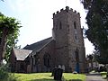 Kerk van Thurmaston


Geplaatst op:
3-8-2010 |
Dit artikel is een beginnetje over landen & volken. U wordt uitgenodigd om op bewerken te klikken om uw kennis aan dit artikel toe te voegen. |