
Bestand:Netherlands during French administration 1810-1814.png

Grootte van deze voorvertoning: 408 × 599 pixels. Andere resoluties: 163 × 240 pixels | 520 × 764 pixels.
Oorspronkelijk bestand (520 × 764 pixels, bestandsgrootte: 889 kB, MIME-type: image/png)
| Dit is een bestand van Wikimedia Commons. Onderstaande beschrijving komt van de beschrijving van het bestand daar. |
Beschrijving
| Beschrijving |
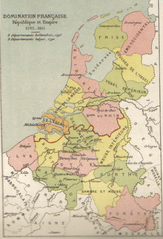
English: Map of Belgium and the Netherlands during the French occupation. Français : Carte de la Belgique et des Pays-Bas pendant l'occupation française. |
||||||||||||||||||||
| Datum | voor 1910 | ||||||||||||||||||||
| Bron | Scan from Atlas de géographie physique, politique et historique à l'usage de l'enseignement primaire et de l'enseignement moyen, Dessain, Liège, 35e éd., s.d., p. 40. | ||||||||||||||||||||
| Auteur |
|
||||||||||||||||||||

Licentie
|
Dit werk bevindt zich in het publiek domein in landen en gebieden waar de auteursrechttermijn het leven van de auteur plus 100 jaar of minder is. Dit werk bevindt zich in het publiek domein in de Verenigde Staten omdat het gepubliceerd werd (of geregistreerd bij de U.S. Copyright Office) voor 1 januari 1929. | |
| Van dit bestand is vastgesteld dat er geen bekende auteursrechtaanspraken op rusten, alle aanverwante en naburige rechten daarbij inbegrepen. | |
Bestandsgeschiedenis
Klik op een datum/tijd om het bestand te zien zoals het destijds was.
| Datum/tijd | Miniatuur | Afmetingen | Gebruiker | Opmerking | |
|---|---|---|---|---|---|
| huidige versie | 31 okt 2005 13:16 | | 520 × 764 (889 kB) | BrightRaven | Map of Belgium and the Netherlands during the French occupation. Author : MG Alexis |
Bestandsgebruik
Dit bestand wordt op de volgende 3 pagina's gebruikt:
Globaal bestandsgebruik
De volgende andere wiki's gebruiken dit bestand:
- Gebruikt op ar.wikipedia.org
- Gebruikt op ast.wikipedia.org
- Gebruikt op br.wikipedia.org
- Gebruikt op ca.wikipedia.org
- Gebruikt op cs.wikipedia.org
- Gebruikt op en.wikipedia.org
- Gebruikt op eo.wikipedia.org
- Gebruikt op es.wikipedia.org
- Gebruikt op fr.wikipedia.org
- Gebruikt op fy.wikipedia.org
- Gebruikt op gl.wikipedia.org
- Gebruikt op id.wikipedia.org
- Gebruikt op it.wikipedia.org
- Gebruikt op la.wikipedia.org
- Gebruikt op li.wikipedia.org
- Gebruikt op mt.wikipedia.org
- Gebruikt op vls.wikipedia.org
- Gebruikt op zh.wikipedia.org