
Bestand:1650 Jansson Wind Rose, Anemographic Chart, or Map of the Winds - Geographicus - Anemographica-jannson-1650.jpg
Grootte van deze voorvertoning: 750 × 599 pixels. Andere resoluties: 301 × 240 pixels | 601 × 480 pixels | 961 × 768 pixels | 1.280 × 1.023 pixels | 2.560 × 2.045 pixels | 5.000 × 3.995 pixels.
Oorspronkelijk bestand (5.000 × 3.995 pixels, bestandsgrootte: 7,38 MB, MIME-type: image/jpeg)
| Dit is een bestand van Wikimedia Commons. Onderstaande beschrijving komt van de beschrijving van het bestand daar. |
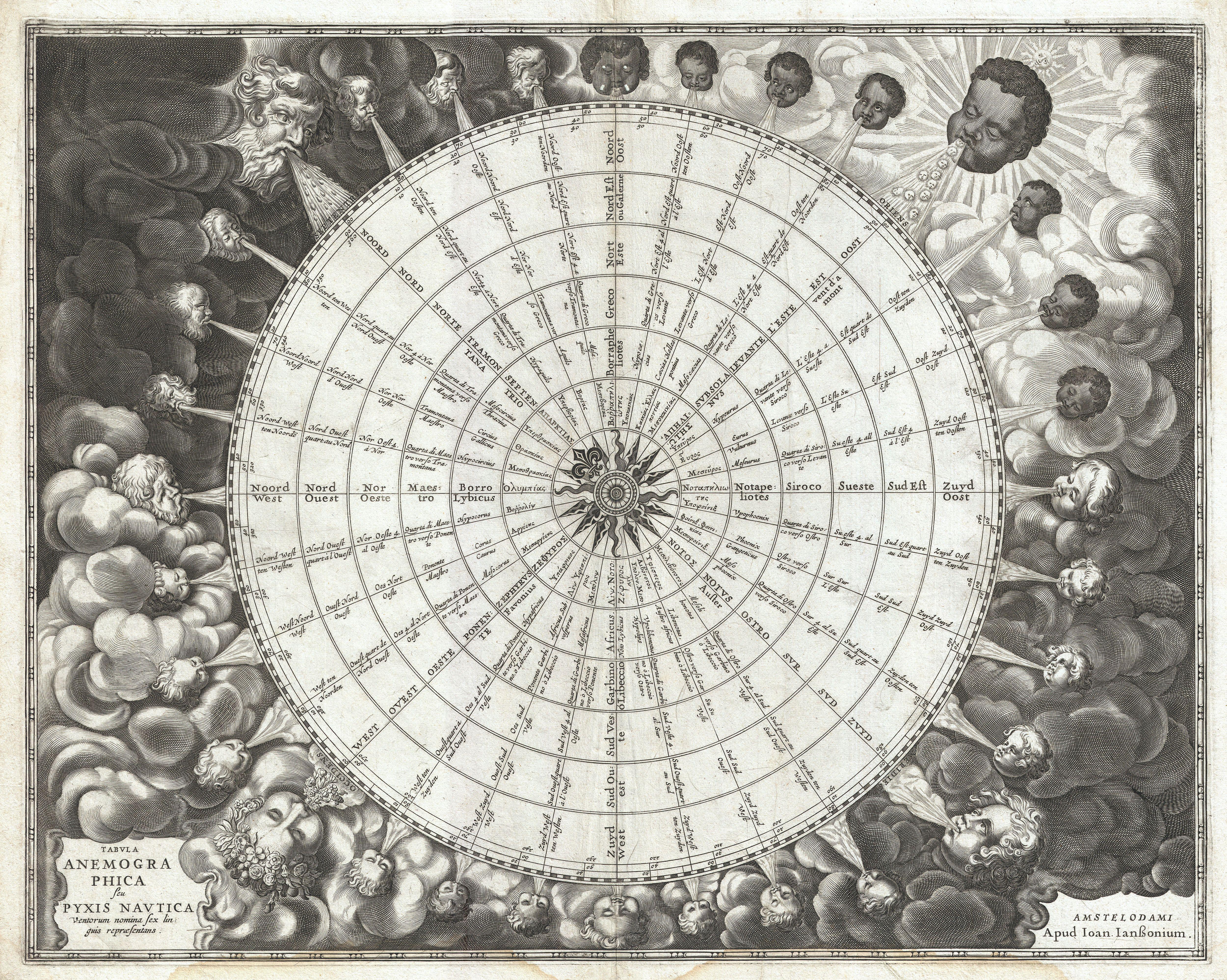
| Johannes Janssonius: Tabula Anemographica seu Pyxis Nautica Ventorum Nomina Sex Linguis Repraesentans.
( |
||||||||||||||||||||||||||
|---|---|---|---|---|---|---|---|---|---|---|---|---|---|---|---|---|---|---|---|---|---|---|---|---|---|---|
| Kunstenaar |
|
|||||||||||||||||||||||||
| Titel |
Tabula Anemographica seu Pyxis Nautica Ventorum Nomina Sex Linguis Repraesentans. |
|||||||||||||||||||||||||
| Beschrijving |
English: An exceptionally rare example of one of the earliest and most significant anemographic, or wind rose, charts to appear in the 17th century. This unusual chart represents a transitional point in the perception of direction, or to be precise, the transition from the wind rose to the compass rose. Early mariners in the Mediterranean defined direction by the names the various winds and the points from which they blew. This idea traces its roots to ancient Greece. Homer identified four cardinal winds, but as navigation and cartography advanced, more were added. This chart represents a full thirty-two named winds and a multitude of different wind systems. Each of the winds is identified by several different names in Greek, Latin, French, and Dutch. Each wind is additionally attached to both contemporary compass points, north west east and south, and a more sophisticated circle and degree system. In the areas surrounding the sphere, each wind is personified by a figure bearing the racial characteristics associated with the region or direction represented. The upper left quadrant, representing north, depicts bearded Germans or Scandinavians. The upper right, representing east, shows beardless dark skinned faces. The beardless and pale skinned figures in the lower left and right, representing west and south, are less distinguishable but may be intended to represent indigenous Americans and Greeks. Anemographic charts, like this, were functional objects and valuable reference tools. Early navigators, referring to the directions as winds, might sail by the north wind. This was exceptionally practical when trade winds dictated ocean commerce. A warm wind from the south, for example might suggest that certain routes, closed for part of the year, were now open. A navigator would have used this chart to compare different names for directions. So, he may be using a chart made in Greece that identified the winds by the names of Greek gods, but himself been trained to use to a different, say Catalan or English, nomenclature. With this chart, he could figure out what various sailing logs and navigation books were referring to. Remember, while nautical charts did exist in the 1600s, most navigation was accomplished using Pilot Books that had instructions like this follow the south wind for 3 days before turning with the eastern wind etc. Thus this was a very useful object indeed. This chart was published as plate 1 in Jansonnius' 1650 Atlas Maritimus or volume 5 in his Atlantis Majoris . |
|||||||||||||||||||||||||
| Datum | 1650 (undated) | |||||||||||||||||||||||||
| Afmetingen | hoogte: 17,5 in (44,4 cm); breedte: 22 in (55,8 cm) | |||||||||||||||||||||||||
| Inventarisnummer |
Geographicus link: Anemographica-jannson-1650 |
|||||||||||||||||||||||||
| Bron/fotograaf |
Jansson, J., Atlantis majoris quinta pars, orbem maritimum seu omnium marium orbis terrarium…, c. 1650.
|
|||||||||||||||||||||||||
| Toestemming (Hergebruik van dit bestand) |
|
|||||||||||||||||||||||||
Bestandsgeschiedenis
Klik op een datum/tijd om het bestand te zien zoals het destijds was.
| Datum/tijd | Miniatuur | Afmetingen | Gebruiker | Opmerking | |
|---|---|---|---|---|---|
| huidige versie | 23 mrt 2011 22:51 | | 5.000 × 3.995 (7,38 MB) | BotMultichillT | {{subst:User:Multichill/Geographicus |link=http://www.geographicus.com/P/AntiqueMap/Anemographica-jannson-1650 |product_name=1650 Jansson Wind Rose, Anemographic Chart, or Map of the Winds |map_title=Tabula Anemographica seu Pyxis Nautica Ventorum Nomina |
Bestandsgebruik
Dit bestand wordt op de volgende pagina gebruikt:
Globaal bestandsgebruik
De volgende andere wiki's gebruiken dit bestand:
- Gebruikt op de.wikipedia.org
- Gebruikt op el.wikipedia.org