
Bestand:1852 Jansson Map of Europe in Antiquity - Geographicus - EuropeAncient-jansson-1652.jpg

Grootte van deze voorvertoning: 754 × 600 pixels. Andere resoluties: 302 × 240 pixels | 603 × 480 pixels | 965 × 768 pixels | 1.280 × 1.019 pixels | 2.560 × 2.037 pixels | 4.000 × 3.183 pixels.
Oorspronkelijk bestand (4.000 × 3.183 pixels, bestandsgrootte: 4,12 MB, MIME-type: image/jpeg)
| Dit is een bestand van Wikimedia Commons. Onderstaande beschrijving komt van de beschrijving van het bestand daar. |
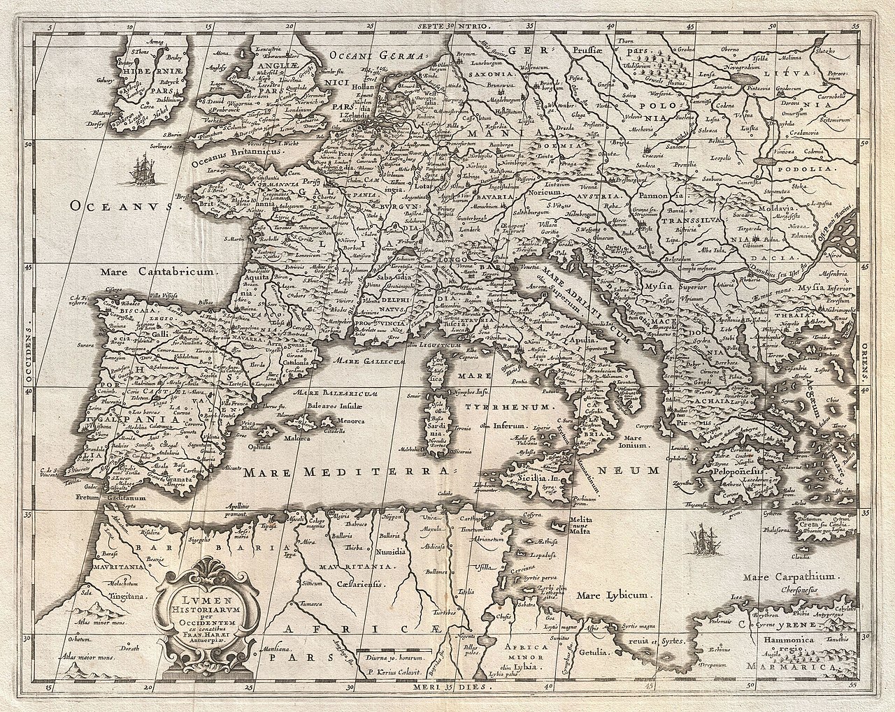
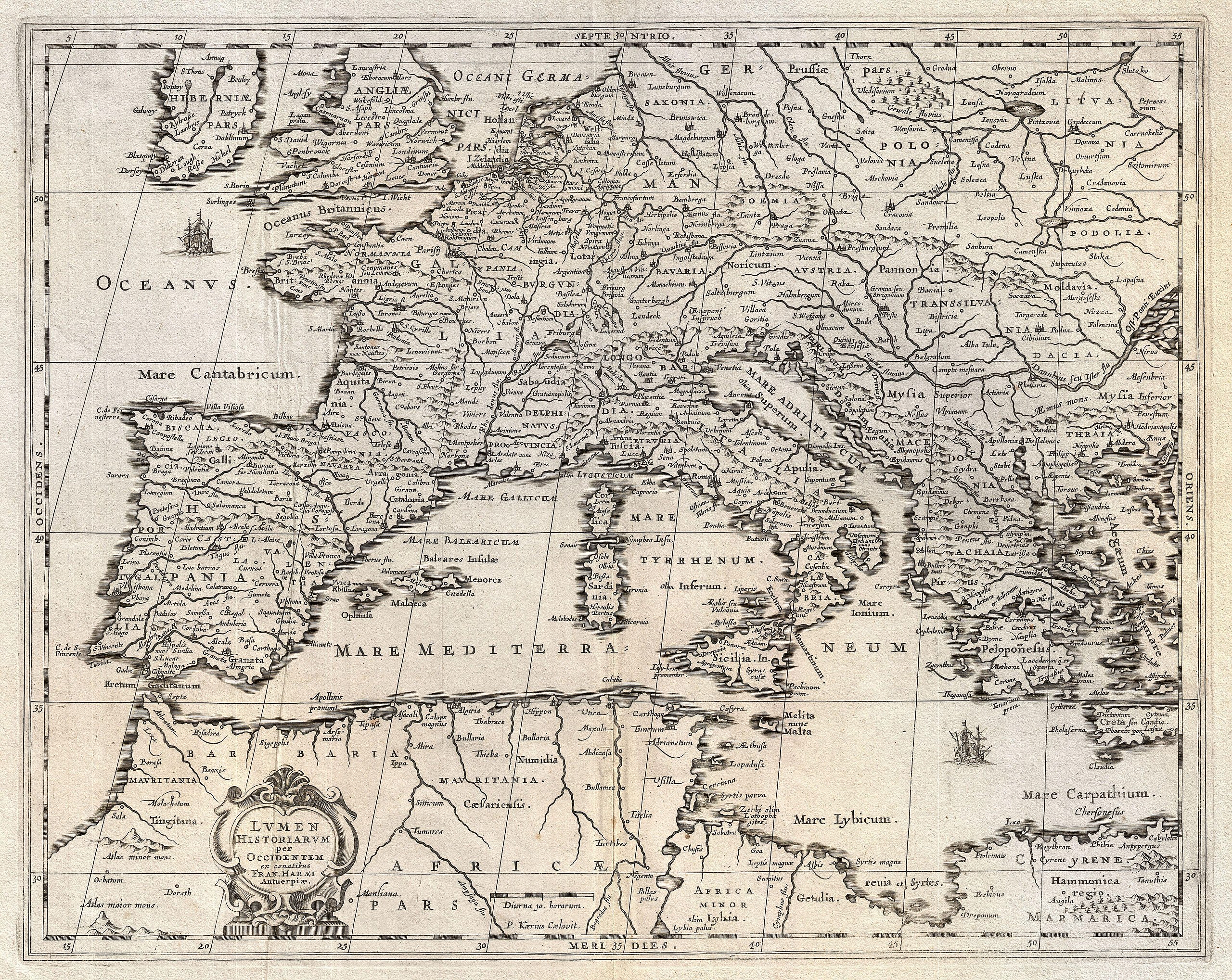
| Johannes Janssonius: Lumen Historiarum per Occidentem.
( |
||||||||||||||||||||||||||
|---|---|---|---|---|---|---|---|---|---|---|---|---|---|---|---|---|---|---|---|---|---|---|---|---|---|---|
| Kunstenaar |
|
|||||||||||||||||||||||||
| Titel |
Lumen Historiarum per Occidentem. |
|||||||||||||||||||||||||
| Beschrijving |
English: An exceptional c. 1652 map of Europe by Jan Jansson. Centered on Italy, this map covers from Spain to Greece and from England to northern Africa. Designed by Frans van Haren (Haraeus), a Dutch theologian and globe maker active from about 1615 to 1624. Depicts Europe as know to the Ancients. Cartographically this map exhibits heavy influence from a very similar map of the same name published by A. Ortelius in his 1597 Parergon . Based on Greek and Roman sources including Pliny, Strabo, Virgil, Caesar, and others. Ships and monsters decorate the seas. A decorative baroque title cartouche appears in the lower left quadrant. This remarkable map was published in volume six, the Orbis Antiquus , of Jan Jansson's Novus Atlas . |
|||||||||||||||||||||||||
| Datum | 1652 (undated) | |||||||||||||||||||||||||
| Afmetingen | hoogte: 15,5 in (39,3 cm); breedte: 19,5 in (49,5 cm) | |||||||||||||||||||||||||
| Inventarisnummer |
Geographicus link: EuropeAncient-jansson-1652 |
|||||||||||||||||||||||||
| Bron/fotograaf |
Jansson, J., Novus Atlas, Sive Theatrum Orbis Terrarum: In quo Orbis Antiquus, Seu Geographia Vetus, Sacra & Profana exhibetur, Volume 6, 1657.
|
|||||||||||||||||||||||||
| Toestemming (Hergebruik van dit bestand) |
|
|||||||||||||||||||||||||
Bestandsgeschiedenis
Klik op een datum/tijd om het bestand te zien zoals het destijds was.
| Datum/tijd | Miniatuur | Afmetingen | Gebruiker | Opmerking | |
|---|---|---|---|---|---|
| huidige versie | 23 mrt 2011 23:35 | | 4.000 × 3.183 (4,12 MB) | BotMultichillT | {{subst:User:Multichill/Geographicus |link=http://www.geographicus.com/P/AntiqueMap/EuropeAncient-jansson-1652 |product_name=1852 Jansson Map of Europe in Antiquity |map_title=Lumen Historiarum per Occidentem. |description=An exceptional c. 1652 map of Eu |
Bestandsgebruik
Dit bestand wordt op de volgende 3 pagina's gebruikt:
Globaal bestandsgebruik
De volgende andere wiki's gebruiken dit bestand:
- Gebruikt op arz.wikipedia.org
- Gebruikt op www.wikidata.org