
Bestand:2011-P02-Friesland-b54.jpg

Grootte van deze voorvertoning: 751 × 600 pixels. Andere resoluties: 301 × 240 pixels | 601 × 480 pixels | 962 × 768 pixels | 1.280 × 1.022 pixels | 1.625 × 1.298 pixels.
Oorspronkelijk bestand (1.625 × 1.298 pixels, bestandsgrootte: 1,03 MB, MIME-type: image/jpeg)
| Dit is een bestand van Wikimedia Commons. Onderstaande beschrijving komt van de beschrijving van het bestand daar. |
Beschrijving
| Beschrijving |
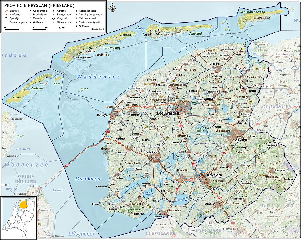
Nederlands: Provincie Fryslân (Friesland), met indeling van gemeenten (2011) en impressie van het landschap.
Door Jan-Willem van Aalst, samengesteld uit publiek beschikbare geo-data:
|
| Datum | |
| Bron | Eigen werk |
| Auteur | Janwillemvanaalst |
| Andere versies | 2009-Basisbeeld-Provincie02-Fryslan.jpg; 2010-P02-Fryslan-basisbeeld.jpg |
Licentie
Ik, de auteursrechthebbende van dit werk, maak het hierbij onder de volgende licentie beschikbaar:
Dit bestand is gelicenseerd onder de Creative Commons-licentie Naamsvermelding-Gelijk delen 3.0 Unported
- De gebruiker mag:
- Delen – het werk kopiëren, verspreiden en doorgeven
- Remixen – afgeleide werken maken
- Onder de volgende voorwaarden:
- naamsvermelding – U moet op een gepaste manier aan naamsvermelding doen, een link naar de licentie geven, en aangeven of er wijzigingen in het werk zijn aangebracht. U mag dit op elke redelijke manier doen, maar niet zodanig dat de indruk wordt gewekt dat de licentiegever instemt met uw werk of uw gebruik van zijn werk.
- Gelijk delen – Als u het werk heeft geremixt, veranderd, of erop heeft voortgebouwd, moet u het gewijzigde materiaal verspreiden onder dezelfde licentie als het oorspronkelijke werk, of een daarmee compatibele licentie.
Bestandsgeschiedenis
Klik op een datum/tijd om het bestand te zien zoals het destijds was.
| Datum/tijd | Miniatuur | Afmetingen | Gebruiker | Opmerking | |
|---|---|---|---|---|---|
| huidige versie | 5 jun 2011 07:52 | | 1.625 × 1.298 (1,03 MB) | Janwillemvanaalst | Added various village/town names |
| 15 mei 2011 08:49 |  | 1.622 × 1.296 (1,03 MB) | Janwillemvanaalst | Revision of sea and coastline; updated infrastructure (local roads) and points of interest (added WTC Expo center, Leeuwarden) | |
| 24 apr 2011 09:05 |  | 1.541 × 1.231 (973 kB) | Janwillemvanaalst | Updates of names, recreation locations, roads | |
| 9 mrt 2011 18:52 |  | 1.541 × 1.231 (948 kB) | Janwillemvanaalst | Added public health services; added regional road labels (N-roads) | |
| 23 feb 2011 20:59 |  | 1.541 × 1.231 (938 kB) | Janwillemvanaalst | Added local airports; Added Golf courses; Added major city parks. | |
| 13 feb 2011 10:39 |  | 1.541 × 1.231 (933 kB) | Janwillemvanaalst | Various map updates and some omissions corrected. Added various tourist locations. | |
| 31 dec 2010 13:06 |  | 1.460 × 1.166 (793 kB) | Janwillemvanaalst | {{Information |Description={{nl|1=Provincie Fryslân (Friesland), met indeling van gemeenten (2011) en impressie van het landschap. Door Jan-Willem van Aalst, samengesteld uit publiek beschikbare geo-data: * Referentie-ondergrond (kustlijn, steden, wegen) |
Bestandsgebruik
Dit bestand wordt op de volgende pagina gebruikt:
Globaal bestandsgebruik
De volgende andere wiki's gebruiken dit bestand:
- Gebruikt op el.wikipedia.org
- Gebruikt op fy.wikipedia.org
- Gebruikt op is.wikipedia.org
- Gebruikt op ru.wikipedia.org