
Bestand:AfricaMap2.jpg

Grootte van deze voorvertoning: 800 × 307 pixels. Andere resoluties: 320 × 123 pixels | 640 × 245 pixels | 1.781 × 683 pixels.
Oorspronkelijk bestand (1.781 × 683 pixels, bestandsgrootte: 225 kB, MIME-type: image/jpeg)
| Dit is een bestand van Wikimedia Commons. Onderstaande beschrijving komt van de beschrijving van het bestand daar. |
Beschrijving
| Beschrijving |
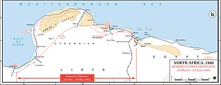
English: Axis movements are depicted in red, and Allied positions are denoted by blue lines. Key dates are shown in boxes. |
| Datum | |
| Bron |
Archive link to original website used for the map and the archive link to the map source page. Current link to map, and link to map source page. |
| Auteur | The History Department of the United States Military Academy |
| Toestemming (Hergebruik van dit bestand) |
US Government document |


Licentie
Deze afbeelding is een werk van een soldaat of werknemer van de U.S. Army, genomen of gemaakt tijdens de uitvoering van diens officiële taken. Als werk van de federale overheid van de Verenigde Staten bevindt deze afbeelding zich in het publiek domein.
|
 |
Oorspronkelijk uploadlogboek
De oorspronkelijke beschrijving van deze afbeelding stond hier. Alle volgende gebruikersnamen verwijzen naar en.wikipedia.
- 2004-08-20 12:42 GeneralPatton 1202×446×8 (107723 bytes) Rommel's first offensive -- [[March 24]], [[1941]] - [[June 15]], [[1941]]
Bestandsgeschiedenis
Klik op een datum/tijd om het bestand te zien zoals het destijds was.
| Datum/tijd | Miniatuur | Afmetingen | Gebruiker | Opmerking | |
|---|---|---|---|---|---|
| huidige versie | 2 apr 2021 03:31 | 1.781 × 683 (225 kB) | EnigmaMcmxc | hi rez version and meta data fix | |
| 8 jan 2021 17:04 | 951 × 364 (93 kB) | EnigmaMcmxc | Updated version of the map from the sourced website | ||
| 29 aug 2010 23:04 | 1.202 × 446 (119 kB) | Hohum | Cleaned | ||
| 28 apr 2007 21:16 | 1.202 × 446 (105 kB) | Kameraad Pjotr | {{Information |Description=Rommel's first offensive <br/>US ARMY <br/>License: US Government document. Printed by the Government printing office. |Source=Originally from [http://en.wikipedia.org en.wikipedia]; description page is/was [http://en.wikipedi |
Bestandsgebruik
Dit bestand wordt op de volgende pagina gebruikt:
Globaal bestandsgebruik
De volgende andere wiki's gebruiken dit bestand:
- Gebruikt op en.wikipedia.org
- Gebruikt op ro.wikipedia.org
- Gebruikt op th.wikipedia.org