
Bestand:Amazonrivermap.png
Grootte van deze voorvertoning: 600 × 600 pixels. Andere resoluties: 240 × 240 pixels | 480 × 480 pixels | 1.000 × 1.000 pixels.
Oorspronkelijk bestand (1.000 × 1.000 pixels, bestandsgrootte: 551 kB, MIME-type: image/png)
| Dit is een bestand van Wikimedia Commons. Onderstaande beschrijving komt van de beschrijving van het bestand daar. |

|
Bestand:Amazonrivermap.svg is een vectorversie van dit bestand. Indien niet van slechtere kwaliteit dient deze gebruikt te worden in plaats van deze rasterafbeelding.
File:Amazonrivermap.png → File:Amazonrivermap.svg
Zie Help:SVG voor meer informatie. |
 |
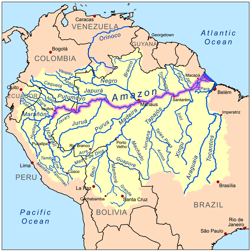
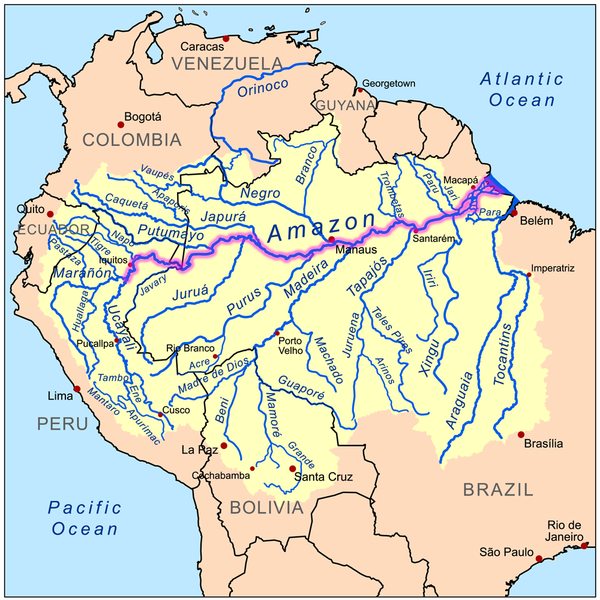
| Beschrijving | This is a map of the Amazon River drainage basin with the Amazon River highlighted. |
| Datum | |
| Bron | Own work using Digital Chart of the World and GTOPO data. |
| Auteur | Kmusser |
Ik, de auteursrechthebbende van dit werk, maak het hierbij onder de volgende licentie beschikbaar:
Dit bestand is gelicenseerd onder de Creative Commons-licentie Naamsvermelding-Gelijk delen 3.0 Unported
- De gebruiker mag:
- Delen – het werk kopiëren, verspreiden en doorgeven
- Remixen – afgeleide werken maken
- Onder de volgende voorwaarden:
- naamsvermelding – U moet op een gepaste manier aan naamsvermelding doen, een link naar de licentie geven, en aangeven of er wijzigingen in het werk zijn aangebracht. U mag dit op elke redelijke manier doen, maar niet zodanig dat de indruk wordt gewekt dat de licentiegever instemt met uw werk of uw gebruik van zijn werk.
- Gelijk delen – Als u het werk heeft geremixt, veranderd, of erop heeft voortgebouwd, moet u het gewijzigde materiaal verspreiden onder dezelfde licentie als het oorspronkelijke werk, of een daarmee compatibele licentie.
Bestandsgeschiedenis
Klik op een datum/tijd om het bestand te zien zoals het destijds was.
| Datum/tijd | Miniatuur | Afmetingen | Gebruiker | Opmerking | |
|---|---|---|---|---|---|
| huidige versie | 19 dec 2022 21:02 | | 1.000 × 1.000 (551 kB) | Italyoz484 | |
| 1 sep 2022 19:04 |  | 1.000 × 1.000 (583 kB) | Wolf170278 | Tocantins doesn't belong to the amazon river basin | |
| 8 sep 2008 19:15 |  | 1.000 × 1.000 (551 kB) | Kmusser | {{Information |Description=This is a map of the Amazon River drainage basin with the Amazon River highlighted. |Source=Own work using http://www.maproom.psu.edu/dcw/ Digital Chart of the World and [[http://edc.usgs.gov/products/el |
Bestandsgebruik
Geen enkele pagina gebruikt dit bestand.
Globaal bestandsgebruik
De volgende andere wiki's gebruiken dit bestand:
- Gebruikt op da.wikipedia.org
- Gebruikt op de.wikipedia.org
- Gebruikt op de.wikinews.org
- Gebruikt op en.wikipedia.org
- Gebruikt op he.wikipedia.org
- Gebruikt op ko.wikipedia.org
- Gebruikt op lez.wikipedia.org
- Gebruikt op nn.wikipedia.org
- Gebruikt op no.wikipedia.org