
Bestand:Cape Verde hurricane track.jpg

Grootte van deze voorvertoning: 800 × 296 pixels. Andere resoluties: 320 × 118 pixels | 640 × 237 pixels | 1.024 × 379 pixels | 2.550 × 944 pixels.
Oorspronkelijk bestand (2.550 × 944 pixels, bestandsgrootte: 317 kB, MIME-type: image/jpeg)
| Dit is een bestand van Wikimedia Commons. Onderstaande beschrijving komt van de beschrijving van het bestand daar. |
| Beschrijving |
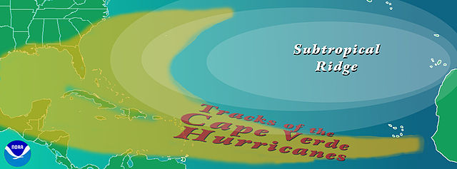
English: Graphic showing the typical track of a en:Cape Verde-type hurricane. The tracks begin south of en:Cape Verde in the eastern en:Atlantic Ocean.
Copyright statusThe NOAA emblem is the property of the U.S. Government and a trademark of the en:United States Department of Commerce. SourceNOAA graphic from http://www.aoml.noaa.gov/hrd/tcfaq/CVtrak.jpg en:nl:Afbeelding:KaapverdischeOrkanen.jpg |
| Datum | 16 juli 2004 (originele uploaddatum) |
| Bron | Verplaatst vanaf en.wikipedia naar Commons door OhanaUnited. |
| Auteur | De originele uploader was Cyrius op de Engelstalige Wikipedia |
| Andere versies |
|
Licentie


Deze afbeelding is in het publiek domein omdat het materiaal bevat dat oorspronkelijk van de National Oceanic and Atmospheric Administration kwam in de Verenigde Staten en genomen of gemaakt is tijdens de officiële werkzaamheden van een werknemer.
|
Oorspronkelijk uploadlogboek
De oorspronkelijke beschrijving van deze afbeelding stond hier. Alle volgende gebruikersnamen verwijzen naar en.wikipedia.
- 2004-07-16 00:36 Cyrius 2550×944×??? (324839 bytes) PD graphic from NOAA
Bestandsgeschiedenis
Klik op een datum/tijd om het bestand te zien zoals het destijds was.
| Datum/tijd | Miniatuur | Afmetingen | Gebruiker | Opmerking | |
|---|---|---|---|---|---|
| huidige versie | 21 aug 2008 19:40 | 2.550 × 944 (317 kB) | OhanaUnited | {{Information |Description={{en|Graphic showing the typical track of a en:Cape Verde-type hurricane. The tracks begin south of en:Cape Verde in the eastern en:Atlantic Ocean. ==Copyright status== The NOAA emblem is the property of the [[:e |
Bestandsgebruik
Dit bestand wordt op de volgende pagina gebruikt:
Globaal bestandsgebruik
De volgende andere wiki's gebruiken dit bestand:
- Gebruikt op ca.wikipedia.org
- Gebruikt op en.wikipedia.org
- Gebruikt op es.wikipedia.org
- Gebruikt op eu.wikipedia.org
- Gebruikt op fr.wikipedia.org
- Gebruikt op it.wikipedia.org
- Gebruikt op ko.wikipedia.org
- Gebruikt op pt.wikipedia.org
- Gebruikt op uk.wikipedia.org
- Gebruikt op www.wikidata.org