
Bestand:Desha County Arkansas 2010 Township Map small.jpg
Geen hogere resolutie beschikbaar.
Desha_County_Arkansas_2010_Township_Map_small.jpg (500 × 522 pixels, bestandsgrootte: 71 kB, MIME-type: image/jpeg)
| Dit is een bestand van Wikimedia Commons. Onderstaande beschrijving komt van de beschrijving van het bestand daar. |
Beschrijving
| Beschrijving |
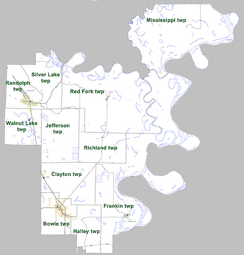
English: This is a map showing townships in Desha County, Arkansas. Modified from US census map (for 2010 census) for Desha County, Arkansas
A larger version of this map is available. |
| Datum | |
| Bron | My own work, based on public domain information. |
| Auteur | User Yx7791 (modified from public domain US Census Bureau map) |
map showing townships in Desha County, Arkansas, United States
Licentie
| Ik, de auteursrechthebbende van dit werk, geef dit werk vrij in het publieke domein. Dit is wereldwijd van toepassing. In sommige landen is dit wettelijk niet mogelijk; in die gevallen geldt: Ik sta iedereen toe dit werk voor eender welk doel te gebruiken, zonder enige voorwaarden, tenzij zulke voorwaarden door de wet worden voorgeschreven. |
Bestandsgeschiedenis
Klik op een datum/tijd om het bestand te zien zoals het destijds was.
| Datum/tijd | Miniatuur | Afmetingen | Gebruiker | Opmerking | |
|---|---|---|---|---|---|
| huidige versie | 22 aug 2011 01:43 | | 500 × 522 (71 kB) | Yx7791 | {{Information |Description ={{en|1=This is a map showing townships in Desha County, Arkansas. Modified from [http://www2.census.gov/geo/maps/dc10map/GUBlock/st05_ar/county/c05041_desha/DC10BLK_C05041_000.pdf US census map (for 2010 census) for Desha Co |
Bestandsgebruik
Dit bestand wordt op de volgende pagina gebruikt:
Globaal bestandsgebruik
De volgende andere wiki's gebruiken dit bestand:
- Gebruikt op en.wikipedia.org