
Bestand:Didemnum.jpg

Grootte van deze voorvertoning: 393 × 599 pixels. Andere resoluties: 157 × 240 pixels | 525 × 800 pixels.
Oorspronkelijk bestand (525 × 800 pixels, bestandsgrootte: 166 kB, MIME-type: image/jpeg)
| Dit is een bestand van Wikimedia Commons. Onderstaande beschrijving komt van de beschrijving van het bestand daar. |
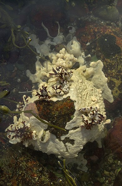
| Beschrijving | Image DB_STP_DSC0146 Tunicate colonies of Didemnum sp. encrusting a boulder and overgrowing dark red algae and pink calcareous algae. Sandwich tide pool (41 deg 46.42 min N lat, 70 deg 29.30 min W lon). Water depth, intertidal range to 11 feet (3.4 m). Collected at low tide. December 4, 2003. Collectors: Mary Carman and Page Valentine. Photo credit: Dann Blackwood, U.S. Geological Survey. |
| Datum | |
| Bron | https://woodshole.er.usgs.gov/project-pages/stellwagen/didemnum/htm/page3.htm |
| Auteur | U.S. Geological Survey/photo by Dann Blackwood (USGS) |
| Toestemming (Hergebruik van dit bestand) |
U.S. public domain |
| Cameralocatie | | Deze en andere afbeeldingen in: OpenStreetMap |
|---|
Deze afbeelding bevindt zich in het publiek domein omdat het materiaal bevat dat oorspronkelijk afkomstig is van de United States Geological Survey, een agentschap van de United States Department of the Interior. Voor meer informatie, zie het officiële USGS-auteursrechtenbeleid
|
Bestandsgeschiedenis
Klik op een datum/tijd om het bestand te zien zoals het destijds was.
| Datum/tijd | Miniatuur | Afmetingen | Gebruiker | Opmerking | |
|---|---|---|---|---|---|
| huidige versie | 13 mrt 2008 20:47 | | 525 × 800 (166 kB) | WarBaCoN | {{Information |Description=Image DB_STP_DSC0146 Tunicate colonies of Didemnum sp. encrusting a boulder and overgrowing dark red algae and pink calcareous algae. Sandwich tide pool (41 deg 46.42 min N lat, 70 deg 29.30 min W lon). Water depth, intertidal r |
Bestandsgebruik
Dit bestand wordt op de volgende 3 pagina's gebruikt:
Globaal bestandsgebruik
De volgende andere wiki's gebruiken dit bestand:
- Gebruikt op ca.wikipedia.org
- Gebruikt op ceb.wikipedia.org
- Gebruikt op en.wikipedia.org
- Gebruikt op es.wikipedia.org
- Gebruikt op fr.wikipedia.org
- Gebruikt op ko.wikipedia.org
- Gebruikt op sv.wikipedia.org
- Gebruikt op tr.wikipedia.org
- Gebruikt op war.wikipedia.org
- Gebruikt op www.wikidata.org
- Gebruikt op zh.wikipedia.org